
Search the Special Collections and Archives Portal

Search Results

Display    Results Per Page
Displaying results 321 - 330 of 812

Map of Las Vegas Rancho, Lincoln County, Nevada, September 15, 1904

Date

1904-09-15

Description

'Being part of Township 20 S. R.61 E. MT. D. B.&.M, containing 1864.49 acres. Division engineer's office at the front, AMB, September 15th, 1904. A.L. Jones, Division Engineer. Surveyed by W.G. Watson, Assistant Engineer. Dwg. 30296.' Includes traverse table. Shows land owned by the San Pedro, Los Angeles & Salt Lake Railroad, its right of way and the right of way for the Las Vegas & Tonopah Railroad, land owned by the Las Vegas Land & Water Company including Clark's Las Vegas Townsite with the Bucks Addition and the Wardie Addition, and parcels sold from the Las Vegas Land & Water Company land. Scale: [1:9,600]. 1 in. to 800 feet. Library's copies 1 and 4 have land owned by the San Pedro, Los Angeles & Salt Lake Railroad hand-colored in pink and the rest of the Las Vegas Rancho not owned by the Las Vegas Land & Water Company hand-colored in green. Library's copy 2 has buildings of the Stewart Ranch drawn in and labeled in pencil. Library's copy 3 has addition and subtraction problems in pencil on the verso. Library's copy 4 has "Original purchase--1864.49 acres R.R.C. + L.V.L. + W. Co.--In colors." written in pencil on the verso followed by "(1904)" in red pencil. Library's copy 4 also has label on verson made of brown paper with "No 5 Las Vegas Ranch being part township ( 1904)" typed on it.

Image

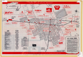
Map of Las Vegas, Nevada, July 1947

Date

1947

Description

'Prepared by Porter & White Agency. Typography by Marc Wilkinson.' 'Travel-Aid. A Ballinger publication, copyright, July 1947.' Panel title: 'Las Vegas, Nevada invites you! : see Boulder Dam, Lake Mead.' Includes information on Las Vegas, business directory, advertisements and directory of service clubs. Advertisements, map of Boulder City, and map of southern Nevada area with advertisements on verso. Ballinger Publishing Company.

Text

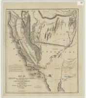
Map of California, Nevada, Utah, Colorado, Arizona & New Mexico, circa 1867

Date

1865 to 1869

Description

39 x 62 cm. Relief shown by hachures and spot heights. Prime meridian: Greenwich and Washington. Hand colored. Shows natural features, populated places, routes of mail steamships, routes of explorers, locations of Indian tribes, railroad routes, and proposed railroad routes. In top margin: No. 80-81. On verso: New Mexico, Arizona, Colorado, Idaho, Dakota (statistics and other information) and The state of California (statistics and other information). Original publisher: G.W. and C.B. Colton.

Image

Map of Oregon and upper California from the surveys of John Charles Frémont and other authorities, 1848

Date

1848

Description

'Drawn by Charles Preuss under the order of the Senate of the United States, Washington City, 1848.' 'Lithy. by E. Weber & Co., Balto.' Relief shown by hachures and spot heights. Shows area of U.S. west of the Continental Divide. Includes explanatory notes and shows Frémont's exploring routes in 1842, 1844 and 1846. Scale 1:3,000,000 (W 124°--W 112°/N 42°--N 32°).

Image

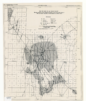
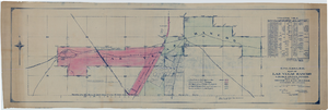
Map of part of Las Vegas Valley showing contours of the composite piezometric surface during the spring of 1944, and specific capacities of wells tapping the confined water

Date

1948

Description

Relief shown by contours. Includes range and township grid. Shows springs and wells. Scale [ca. 1:67,162. 1 in. to approx. 1.06 miles]. Series: Water resources bulletin (Carson City, Nev.)
no. 5. Originally published as plate 8 in Geology and water resources of Las Vegas, Pahrump, and Indian Spring Valleys, Clark and Nye Counties, Nevada by George B. Maxey and C.H. Jameson, which is number 5 of the Water resources bulletin published by the Nevada Office of the State Engineer.

Image

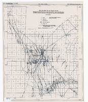
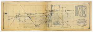
Map of part of Las Vegas Valley showing the piezometric surface of the "near-surface" water during the spring of 1946 by contours, and areas of discharge by evaporation and transpiration

Date

1946

Description

Relief shown by contours. Includes range and township grid. Shows springs, wells and areas of discharge. Scale [ca. 1:67,162. 1 in. to approx. 1.06 miles]. Series: Water resources bulletin (Carson City, Nev.)
no. 5. Originally published as plate 7 in Geology and water resources of Las Vegas, Pahrump, and Indian Spring Valleys, Clark and Nye Counties, Nevada by George B. Maxey and C.H. Jameson, which is number 5 of the Water resources bulletin published by the Nevada Office of the State Engineer.

Image