Search Results
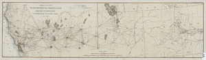
Map of the progress of the transcontinental triangulation and reconnaissance eastward from the Pacific Coast, June 30, 1883
Date
1883-06-30
Description
26 x 93 cm. "Coast and Geodetic Survey report, 1883, no. 23." "June 30, 1883." Original publisher: U.S. Coast and Geodetic Survey, Scale: 1: 2000 000.
Image
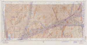
Elko sectional aeronautical chart, September 29, 1959
Date
1959-09-29
Description
52 x 110 cm. Relief shown by gradient tints, contours, and spot heights. Contour interval 1,000 feet. "Aeronautical data on this chart includes data received through Sept. 29, 1959." "Consult appropriate NOTAMS and Radio Facility Charts for supplemental data and current information." "Next edition is scheduled in approximately one year." "Base: Edition of May 1956. Revised Sept. 1958." "Lambert Conformal Conic Projection." "Standard Parallels 33° and 45°." "Elko compiled and printed at Washington, D. C. by the U. S. Coast and Geodetic Survey under authority of the Secretary of Commerce." "Principal sources: U. S. Geological Survey, U. S. Army Corps of Engineers, U. S. Air Force, U. S. Dept. of Agriculture, Civil Aeronautics Administration, and the U. S. Coast and Geodetic Survey." "Base: Edition of May 1956, revised Sept. 1958." "Detailed airport data and other useful information are printed on the back of this chart." Includes text, gradient tints scale and index to adjoining sheets. On verso: text, index map of sectional charts, inset maps of U.S. air defense identification zones and defense area, visual emergency signals, and charts. Original publisher: U.S. Coast and Geodetic Survey, Scale: 1:500,000.
Image
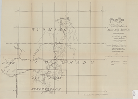
Wagon road from Fort Steele, Wyoming via Rawlins, Union Pacific R.R. to White River Agency, Colo., via cut-off from old road, October, 1878
Date
1878-10
Description
38 x 52 cm. "Topography: Colorado & Utah: U.S. Geolog. Survey Territories, Prof. Hayden in charge and from personal notes & obs--Wyoming: maps, General Land Office & personal notes." "October, 1878." Includes other wagon roads, trails, rivers, ranches, Indian agencies and military reservation. "Drawn by Lieutenant C. A. H. McCauley, 3rd Artillery." "Sen. Ex. Doc. No. 62, 45th Congress 3rd Sess." Original publisher: GPO, Series: Sen. ex. doc no. 62, 45th Congress, 3rd session.
Image

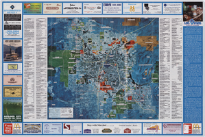
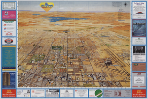
Aerial map of the Las Vegas Valley, with map of Las Vegas, 1992
Date
1992
Description
2 maps on 1 sheet : both sides, col. ; 47 x 51 cm. and 54 x 71 cm. on sheet 61 x 91 cm. Photomap. Includes text about Las Vegas, list of businesses with coordinates for map on verso, and advertisements. On verso: Bird's-eye view map of a section of unincorporated Las Vegas east of the Strip between Charleston and Sunset oriented with north to left and drawn by Jack Tavenner in 1992. Shows locations of schools, lists Boulder City merchants, and includes advertisements. Original Publisher: Landiscor Aerial Photo
Image
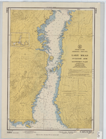
Hydrographic map of Lake Mead, Overton Arm, Southern and Northern Parts
Date
1955-10-17
Description
1st ed., Sept. 1952. Hydrographic chart : color ; 56 x 40 cm. At head of title: United States, Arizona-Nevada. Relief shown by contours, depths shown by soundings. "5458B." "-1952-799." "Catalog page no. 18." On verso: Lake Mead, Overton Arm, southern part. Includes index map. Library's copies have "Compliments of Senator George W. Malone" stamped in red at top on left side. Library's copies have "Corrected through notice to mariners no. 46 Nov. 13 '55" stamped in purple at bottom. Original publisher: U.S. Coast and Geodetic Survey. Scale: 1:48,000
Image
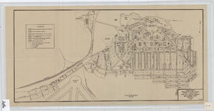
Cadastral map of Boulder City, Nevada, 1940
Date
1905-04-23
Description
A. M. S. Jan. 1940 in the lower left-hand corner. 1 map ; 61 x 30 cm. Cadastral map. "No. 40-1" in the lower right-hand corner. Shows block and lot numbers, buildings, water supply and sewage system, leased areas.
Image
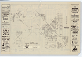
Street map of Henderson, Nevada, 1982
Date
1982
Description
53 x 68 cm. "Industrial center of Nevada, gateway to Lake Mead." Includes advertisements. Index, advertisements, and inset map of Las Vegas area on verso. "Copyright 1981." Original publisher: Chamber of Commerce (Henderson, Nev.). Original publisher: Chamber of Commerce (Henderson, Nev.)
Image
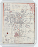
Street map of Las Vegas, 1966
Date
1966
Description
1966 ed. Color; 56 x 43 cm., folded to 23 x 10 cm. Panel title: Street map of Las Vegas and vicinity. On bottom of panel: Humble Oil & Refining Company. Index, photographs of Las Vegas scenes and nearby tourist attractions and map titled Lake Mead National Recreation Area, lower basin section on verso. Original publisher: H. M. Gousha Company.
Image