Search Results
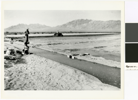
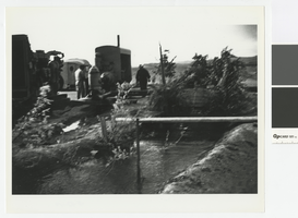
Photograph of farmland on the T & T Ranch, Nevada, circa 1953
Date
Archival Collection
Description
Men irrigating new alfalfa on the T & T Ranch in the Amargosa Valley.
Transcribed Notes: Transcribed from photo sleeve: "Irrigating land newly planted in alfalfa, T & T Ranch, Amargosa Valley, Nevada, about 1952 or 1954. Gordon Bettles is pictured with the shovel. The child pictured in the foreground is a niece of Bob Fishel and Betty Lou Kemp, daughter of M.P. Gless' Glessner. Note the profile of the sleeping old man silhouetted along the crest of the Funeral Mountains."
Image
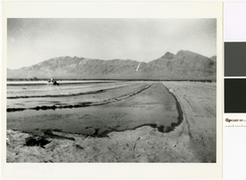
Photograph of irrigated farmland on the T & T Ranch, Nevada, circa 1953
Date
Archival Collection
Description
Irrigating new alfalfa on the T & T Ranch in the Amargosa Valley.
Transcribed Notes: Transcribed from photo sleeve: "Irrigated land newly planted in alfalfa. T & T Ranch, Amargosa Valley, Nevada, Ca. 1954."
Image
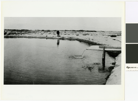
Photograph of John Quincy Lisle at the edge of his reservoir, Las Vegas, circa 1930
Date
Archival Collection
Description
Lisle stands at the edge of the reservoir fed by an artesian well on his homestead.
Transcribed Notes: Transcribed from photo sleeve: "John Quincy "Jack" Lisle at the edge of the reservoir on his homestead in the Las Vegas Valley, about 1930. The reservoir is located not far from the present intersection of Twain and Eastern streets and was one of the best artesian wells in the Las Vegas Valley. At the time it was necessary to make a winding road off the Boulder Highway to reach the homestead. Most people thought that Lisle was absolutely insane to locate a homestead in such a desolate place, but Lisle, and amateur geologist, staked his claim there because he figured that water would be abundant because the land was near the Flamingo Wash. At one time Lisle raised 40 acres of alfalfa on the property."
Image
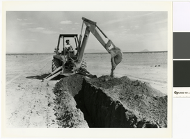
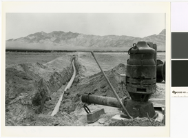
Photograph of backhoe digging a trench for a water line, Amargosa Valley, Nevada, 1980
Date
Archival Collection
Description
A backhoe digging a trench for the installation of an irrigation water line.
Transcribed Notes: Transcribed from photo sleeve: "Digging a ditch for installation of a 10'' water line to supply a sprinkler system in the Amargosa Valley, Nye County, Nevada, 1980."
Image
Photograph of irrigation pump and water line, Amargosa Valley, Nevada, 1980
Date
Archival Collection
Description
View of a water line and pump in the Amargosa Valley looking southwest toward the Funeral Mountains.
Transcribed Notes: Transcribed from photo sleeve: "Amargosa Valley looking southwest toward the Funeral Mountains, 1980, showing a 10" water line and pump to supply a circle sprinkler system. The pump is a 75 horsepower electric turbine pump that supplies two sprinkler systems with a total of 1,450 gallons per minute. At that capacity, the pump only draws water down 3 inches in the well."
Image
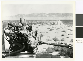
Photograph of a butane powered pump engine on the T & T Ranch, Nevada, circa 1958
Date
Archival Collection
Description
Since the Amargosa Valley did not have electricity until 1964, all pumps were run by combustion engines, like this one on the T & T Ranch.
Transcribed Notes: Transcribed from photo sleeve: "Land on the T & T Ranch, Amargosa Valley, Nye County, Nevada, about 1958 or 1959. Commercial electricity was not available in the Amargosa Valley until 1964. Until then all water pumping was done with combustion engines running at the wells. Pictured here is a butane-operated motor, running a pump on the property belonging to Hank Records."
Image
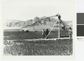
Photograph of a pivot watering system, Hank Record Ranch, Nevada, 1980
Date
Archival Collection
Description
Irrigation pivot watering alfalfa on the property of Hank Records.
Transcribed Notes: Transcribed from photo sleeve: "Amargosa Valley, Nye county, Nevada, 1980. Pivot watering system has just been installed on the property belonging to Hank Records and the alfalfa is beginning to grow. When alfalfa is first seeded, oats are also planted as a cover crop. The oats, which protect the tender alfalfa seedlings, are later cut, and the alfalfa takes over."
Image
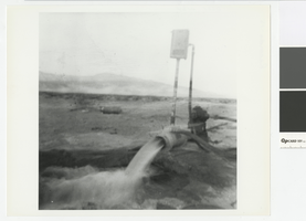
Photograph of water flowing from a pump, Hank Record Ranch, Nevada, 1979
Date
Archival Collection
Description
Water flowing from a pump in the Amargosa Valley.
Transcribed Notes: Transcribed from photo sleeve: "Water flowing from a pump located on the property of Hank Records, Amargosa Valley, Nye County, Nevada, about 1979. the view is toward the west."
Image
Photograph of diesel pumps, Hank Record Ranch, Nevada, 1956
Date
Archival Collection
Description
Diesel pumps on the Record Ranch.
Transcribed Notes: Transcribed from photo sleeve: "Detroit diesels powering pumps on Hank Record's property, Amargosa Valley, Nye County, Nevada, about 1956. (Diesels were installed by Mantzer Detroit Diesel out of Sparks, Nevada.) Records brought the trailer in the background from Prescott, Arizona; it was the first structure in the Amargosa Valley Farm Area aside from those on the T & T Ranch. The trees are Balm of Gileads."
Image
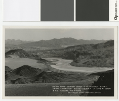
Photographic postcard of Hemenway Wash, Nevada and Colorado River, 1932
Date
Archival Collection
Description
View of the river and Hemenway Wash, with Ragtown (Williamsville) on the banks of the river.
Transcribed Notes: Transcribed from front of postcard: "Hemenway Wash and Colorado River from lookout point near Hoover Dam, Las Vegas, Nevada. Frashers Foto - Pomona, Calif." Transcribed from photo sleeve: "Ragtown/Williamsville at center."
Image