Search Results
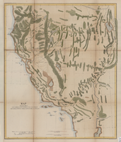
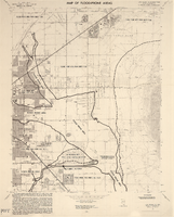
Map showing the different routes travelled over by the detachments of the Overland Command in the spring of 1855 from Salt Lake City, Utah, to the Bay of San Francisco, 1855
Date
1855
Description
57 x 47 cm., folded to 22 x 13 cm. Indicates routes of Capt. Ingalls, Col. Steptoe,and Lt. Mowrey, and shows camping grounds. Relief shown by hachures. Graphic scale given in geographical as well as statute miles. "Ackerman Lith. 319 Broadway, N.Y." Hand colored. Original publisher unknown, Series: House Ex. Doc. No. 1, 1st session, 34th Congress.
Image
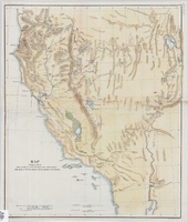
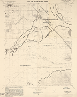
Map showing the different routes travelled over by the detachments of the Overland Command in the spring of 1855 from Salt Lake City, Utah, to the Bay of San Francisco, 1855
Date
1855
Description
57 x 47 cm. Indicates routes of Capt. Ingalls, Col. Steptoe, and Lt. Mowrey, and camping grounds. "Ackerman Lith. 319 Broadway, N.Y." Relief shown by hachures. In Wheat, "Mapping of the Trans-Mississippi West", v. 4, p. 210. Library's copy 1 is poor quality and not in color. Original publisher unknown, Series: Senate Ex. Doc. No. 1, 1st session, 34th Congress.
Image


Las Vegas NE quadrangle
Date
1973
Description
'Prepared by the U.S. Department of the Interior, Geological Survey, in cooperation with the U.S. Department of Housing and Urban Development, Federal Insurance Administration. 1973.'
Image
Las Vegas SE quadrangle
Date
1973
Description
'Prepared by the U.S. Department of the Interior, Geological Survey, in cooperation with the U.S. Department of Housing and Urban Development, Federal Insurance Administration. 1973.'
Image
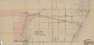
Map showing locations of water bearing lands to be sold to the Las Vegas Valley Water District and boundaries of lands owned by the Union Pacific Railroad not to be sold to the District, April 29,1953
Date
1953-04-29
Description
'Exhibit A. Location of water bearing lands to be sold to the District. Boundary of lands owned by Union Pacific which are not to be sold to the District. April 29, 1953. I-128'
Image