Search Results
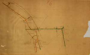
Map of the third level of the Clermont Mine, Goldfield, Nevada, circa 1902-1908
Date
1902 to 1908
Description
Hand-drawn, hand-colored and annotated map showing the third level of the Clermont Mine. 'Clermont, 3rd level, el. 5361.3.'
Image
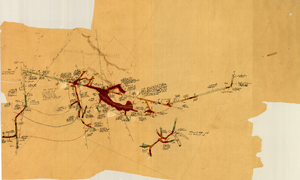
Map of the fourth level of the Clermont Mine, Goldfield, Nevada, circa 1902-1908
Date
1902 to 1908
Description
Hand-drawn, hand-colored and annotated map showing the fourth level of the Clermont Mine. Upper left and lower right corners missing.
Image
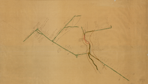
Map of the sixth level of the Clermont Mine, Goldfield, Nevada, circa 1902-1908
Date
1902 to 1908
Description
Hand-drawn, hand-colored and annotated map showing the sixth level of the Claremont Mine. 'Clermont, 6th level, el. 4971.4.'
Image
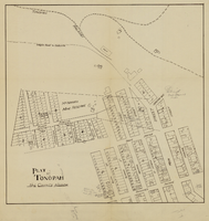
Plat of Tonopah, Nye County, Nevada, circa 1905
Date
1903 to 1907
Description
Plat of properties in downtown Tonopah, Nevada. Notes handwritten in pencil. Southern Nevada Mining Map Collection
Image

Map of underground workings in Potosi and Central Lodes, May 1906
Date
1906-05
Description
'Scale 20 ft = 1 in.'
Image
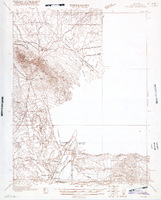
Map of Ely Range Quadrangle, Lincoln County, Nevada, 1921
Date
1921
Description
'Edition of 1921.' 'W. H. Herron, Acting Chief Geographer; Geo. R. Davis, Geographer In Charge; Topography by H. H. Hodgeson, N. E. Ballmer, and W. B. Upton, Jr.; Control by H. H. Hodgeson, Roscoe Reeves, and D. S. Birkett. Surveyed in 1916.' At top of map: ' Topography, State of Nevada.' At upper left corner: ' Department of the Interior, Albert B. Fall, Secretary; U.S. Geological Survey, George Otis Smith, Director.' Southern Nevada Mining Map Collection. 15 minute series (topographic) Nevada.
Image
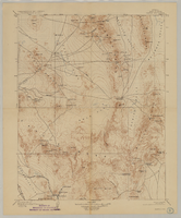
Map of Kawich Quadrangle, Nye County, Nevada, June 1908
Date
1908-06
Description
At upper left corner: 'Department of the Interior, U.S. Geological Survey.' 'E. M. Douglas, geographer; R. G. Chapman, in charge of section; triangulation and topography by R. H. Chapman and B. D. Stewart. Surveyed in 1905.' 'Engraved April 1906 by U.S.G.S.' 'Edition of June 1908, repritned 1929.' 'Polyconic projection. North American datum.' Guide to Topographic Maps of the United States series on map verso. UNLV Special Collections Southern Nevada Mining Map Collection
Text
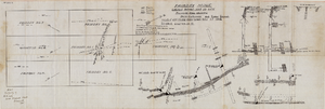
Fairday Mine property map, May 25, 1916
Date
1916-05-25
Description
'Fairday Mine, Cactus Range, Nye Co., Nev. property map showing vein outcrops and underground surface, May 25, 1916.' Handwritten in lower left corner: 'Map property of A.H. Lee, care [of] Tonopah Club, Tonopah, Nev.' 'Scale 200' to the inch.' 'Silver oz. Gold value 1/9.'
Image

Longitudinal section map, Montana Tonopah Mine, circa 1900s-1910s
Date
1900 to 1919
Description
'Longitudinal Section, Montana Tonopah Mine showing workings projected on east-west vertical plane.' In lower right corner: 'E.D. North E.M.' 'Photo-litho. Britton & Rey, S.F.'
Image
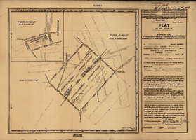
Plat of the claim of George Wingfield, June, 1907
Date
1907-06
Description
'Plat of the claim of George Wingfield, known as the Yankee Doodle and Desert Rose Lodes and Desert Rose Mill Site, in Goldfield Mining District, Esmeralda County, Nevada. Containing an area of 41.318 + 4.841 acres. Scale of 300 feet to the inch. Variation 17° east. Surveyed June 22-25, 1907.' 'Mineral Survey No. 3202 A and B.' 'Pat. # 132432, May 26, 1910.' Certification signed by Matthew Kyle, U.S. General Surveyor's Office, Reno, Nev., December 7, 1907.
Text