Search Results
Map of Utah, New Mexico, Texas, California, Indian territory, and the northern states of Mexico, 1852
Date
1852-01-01
Description
At head of title: 'North America, sheet XV.' 'Published under the superintendence of the Society for Diffusion of Useful Knowledge.' At bottom center of map:'London, Charles Knight, Jany. 1st, 1852.' At bottom right of map: ' J. & C. Walker Sculpt.' Scale [1:7,500,000] 1 degree to 68.89 English miles (W 125°--W 92°/N 43°30?--N 22°30?). Relief shown by hachures. Atlas page number in lower margin: 144. Boundaries hand colored. Includes notes, locations of Indian tribes, population statistics. Charles Knight.
Image
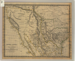
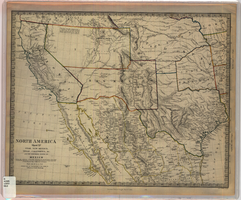
Map of Texas, California, New Mexico and the northern states of Mexico, October 15, 1842
Date
1842-10-15
Description
'Published under the superintendence of the Society for Diffusion of Useful Knowledge.' 'Published by Chapman & Hall, 186 Strand, 15 Oct. 1842.' 'J. & C. Walker, Sculpt.' Scale [ca. 1:7,600,000]. 1 in. to ca. 120 miles (W 125°--W 91°/N 43°--N 23° 30?). 1 map ; 31 x 39 cm. Relief indicated by hachures and spot heights. Shows elevations in yards. Includes notes on exploring expeditions, etc. Borders hand colored. Chapman & Hall.
Image
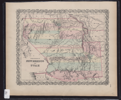
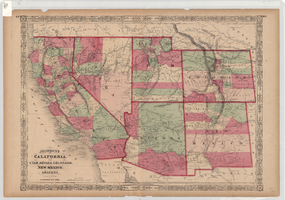
Map showing the territories of New Mexico and Utah, 1855
Date
1855
Description
'Entered according to Act of Congress in the year 1855 by J.H. Colton & Co. in the Clerk's Office of the Dist. Court of the U.S. for the South'n. Dist. of New York.' Scale [ca. 1:4,752,000. 1 in. to approx. 75 miles] (W 120°--W 102°/N 43°--N 32°). Shows natural features, and populated places, wagon route, proposed railroad routes and explorers' routes. Relief shown by hachures. Prime meridians: Greenwich and Washington.Hand colored. Atlas p. number in lower-right margin: 51. Decorative border. J.H. Colton & Co.
Image
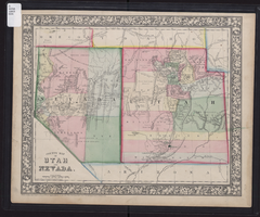
County map of Utah and Nevada, 1865
Date
1865
Description
'Entered according to Act of Congress in the year 1865 by S. Augustus Mitchell, Jr. in the Clerk's office of the District Court of the U.S. for the Eastern District of Pennsylvania . Drawn and engraved by W.H. Gamble, Philadelphia.' Shows roads, overland telegraph route, and other features. Relief shown by hachures and spot heights. Prime meridians: Greenwich and Washington. Scale [ca. 1:2,787,840] (W 120°--W 109°/N 43°--N 36° 59?).
Image
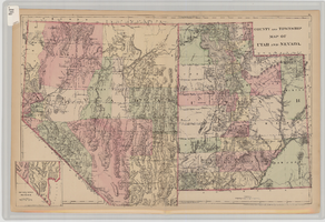
County and township map of Utah and Nevada, 1881
Date
1881
Description
'Entered according to Act of Congress in the year 1881 by S. Augustus Mitchell in the Office of the Librarian of Congress at Washington.' Relief shown by hachures. Prime meridians: Greenwich and Washington. In upper-right corner: 91. Shows range and township grid. Includes inset of southern portion of Nevada Scale [ca. 1:1,750,000]. 1 in. to approx. 27 miles (W 120°--W 109°/N 42°--N 35°).
Image
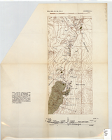
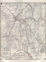
Topographic map of area near Virgin River south of St. Thomas, Nevada, 1936
Date
1936
Archival Collection
Description
Scale [ca. 1:110,880. 1 in. to approx. 1.75 miles]. 'Bull. Geol. Soc. Am., Vol. 47. Longwell Pl. 4.' Published as plate 4 of Longwell's Geology of the Boulder Reservoir floor, Arizona-Nevada. Geological Society of America
Image
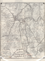
Road map of Hoover Dam and vicinity, circa 1949
Date
1947 to 1951
Description
'Cartography by W. C. Kainsinger, W.T. Taylor. Field mapping by K. R. Reed, G. Boyd. Typography by W. R. Williams.' 'Copyright by Automobile Club of Southern California. C-21351.' 'C-1352'--Panel. Index on verso. In lower right corner: 'Map number 1959.' Scale 1:415,210 (W 116°--W 114°/N 37°--N 35°). Relief shown by hachures and spot heights. Shows mines, ranches and springs. Not the same as the 1948 edition of this map. Cartographers', field mappers', typographers' names are different, and 2 out of 3 numbers on maps are different. Probably after 1947 as Boulder Dam has been changed to Hoover Dam, but before 1950 as Las Vegas Bombing and Gunnery Range has not been changed to Nellis Air Force Base. Automobile Club of Southern California.
Text