Search Results
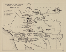
Map of Bureau of Reclamation Region III, August 1, 1945
Date
1945-08-01
Description
31 x 40 cm. "8-1-45. Ness." and "116951" in lower right corner. Shows reclamation projects in operation, under construction, authorized and under study in Arizona, and parts of New Mexico, Utah, Nevada, and California. "Department of the Interior, Bureau of Reclamation" in upper left corner. Original Publisher: Dept. of the Interior, Bureau of Reclamation.
Image
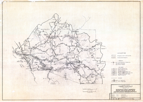
Regional map showing main air, highway, bus and railroad transportation, October 30, 1945
Date
1945-10-30
Description
50 x 70 cm. Blue-line print. Shows Arizona, western New Mexico, southwestern Utah, southern Nevada, and southern California. Also shows irrigation projects constructed and under construction. "Oct. 30, 1945. Rev. 2-14-46." "Drawn and traced by F. R. M." Original publishser: Bureau of Reclamation, Region III.
Image
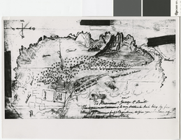
Hand-drawn map of the Mormon Fort and Las Vegas Valley from a letter by John Steele to Brigham Young, circa 1855
Date
1850 to 1859
Archival Collection
Description
Hand-drawn map showing area around the Mormon Fort in Las Vegas, Nevada, circa 1855. Handwritten in lower right: 'To President George A. Smith. This is drawn not according to any particular rule being my first attempt at drawing but it may serve to give you an idea of the Las Vegas. John Steele.' Copy print of material in LDS Archives. Scale not given..
Image
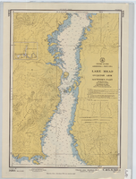
Hydrographic map of Lake Mead, Overton Arm, Southern and Northern Parts
Date
1955-10-17
Description
1st ed., Sept. 1952. Hydrographic chart : color ; 56 x 40 cm. At head of title: United States, Arizona-Nevada. Relief shown by contours, depths shown by soundings. "5458B." "-1952-799." "Catalog page no. 18." On verso: Lake Mead, Overton Arm, southern part. Includes index map. Library's copies have "Compliments of Senator George W. Malone" stamped in red at top on left side. Library's copies have "Corrected through notice to mariners no. 46 Nov. 13 '55" stamped in purple at bottom. Original publisher: U.S. Coast and Geodetic Survey. Scale: 1:48,000
Image

Topographic map of the Boulder Canyon Reservoir site, 1930
Date
1930
Description
Scale [ca. 1:144,000. 1 in. to approx. 12,000 ft.] ; 1 map : col. ; 51 x 91 cm ; Relief shown by contours and spot heights ; "Map no. 23800" ; Includes township and range grid ; Includes two profile diagrams, area and capacity curve diagram, Topography of Black Canyon and vicinity map and Colorado River basin map. Inset maps of Black Canyon and vicinity and Colorado River Basin. Inset charts of Boulder Canyon Reservoir Area and Capacity Curves; and, Profile of Colorado River from Bridge Canyon Dam Site, Arizona to Black Canyon Dam Site, Arizona-Nevada. Bureau of Reclamation.
Image

Map of farm plots of the Las Vegas Mormon Mission, 1855
Date
1855
Archival Collection
Description
Copy print of material in LDS Archives. Scale not given.
Image
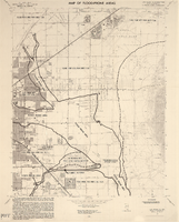
Las Vegas NE quadrangle
Date
1973
Description
'Prepared by the U.S. Department of the Interior, Geological Survey, in cooperation with the U.S. Department of Housing and Urban Development, Federal Insurance Administration. 1973.'
Image
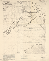
Las Vegas SE quadrangle
Date
1973
Description
'Prepared by the U.S. Department of the Interior, Geological Survey, in cooperation with the U.S. Department of Housing and Urban Development, Federal Insurance Administration. 1973.'
Image

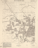
Las Vegas SW quadrangle
Date
1973
Description
'Prepared by the U.S. Department of the Interior, Geological Survey, in cooperation with the U.S. Department of Housing and Urban Development, Federal Insurance Administration. 1973.'
Image
Las Vegas NW quadrangle
Date
1973
Description
'Prepared by the U.S. Department of the Interior, Geological Survey, in cooperation with the U.S. Department of Housing and Urban Development, Federal Insurance Administration. 1973.'
Image