Search Results
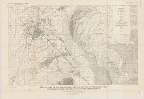
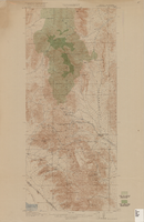
Map of part of Las Vegas Valley, Nevada, showing approximate area of phreatophytes before ground-water development
Date
1965
Description
Genre/Form: Thematic maps. Scale 1:62,500 (W 115°15´--W 114°45´/N 36°15´--N 36°00´). 1 map : col. ; 44 x 72 cm. Series: Water-supply paper (Washington, D.C.) ; 1780. Relief shown by contours. Originally published as plate 10 of Available water supply of the Las Vegas ground-water basin, Nevada, by Glenn T. Malmberg, published by the Geological Survey in 1965 as its Water-supply paper 1780. Includes township and range lines. Interior, Geological Survey
Image
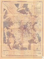
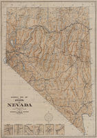
Map and basin profiles showing thickness of valley-fill deposits, Las Vegas Valley, Nevada, 1981
Date
1981
Description
At top of map: 'United States Department of the Interior. Geological Survey. Open-file report 84-130, plate 5.' 'Prepared in cooperation with the Clark County Department of Comprehensive Planning.' At bottom of map: 'Base from U.S. Geological Survey, 1:100,000, Boulder City, Ariz.-Nev., Las Vegas, Nev.-Calif., Mesquite Lake, Nev.-Calif., 1978; Lake Mead, Nev.-Ariz., 1979.' 'Geology from Malmberg (1965); Longwell and others (1965); Haynes (1967); Bell and Smith (1980); Bell (1981) and J. R. Harrill, 1976. Thickness of valley-fill deposits by R.W. Plume, 1981.' Includes three profiles. Shows township and range lines. Scale [ca. 1:95.040. 1 in.=approx. 1.5 miles] (W 115°30´--W 115°00´/N 36°30´--N 36°00´). Series: Open-file report (Geological Survey (U.S.)), 84-130. Originally published as plate 5 of Ground-water conditions in Las Vegas Valley, Clark County, Nevada. Part I. Hydrogeologic framework / by Russell W. Plume, published by the U.S. Geological Survey in 1984 as Open-file report 84-130.
Image