Search Results
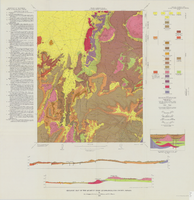
Geologic map of the Quartet Dome quadrangle, Nye County, Nevada, 1966
Date
1966
Description
58 x 46 cm., on sheet 88 x 85 cm., folded in envelope 30 x 24 cm. Relief shown by contours and spot heights. "Contour interval 20 feet." "Base by U.S. Geological Survey, 1962, 10,000-foot grid based on Nevada coordinate system, central zone." "Geology mapped in 1962-63." Includes 2 col. cross sections, diagrammetric stratigraphic section, quadrangle location map, and text. "Prepared in cooperation with the U.S. Atomic Energy Commission." Original publisher: Interior, Geological Survey, Series: Geologic quadrangle map GQ, Scale: 1:24 000.
Image
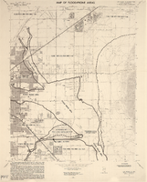
Maps of flood-prone areas in Las Vegas, Nevada, 1973
Date
1973
Description
'Prepared by the U.S. Department of the Interior, Geological Survey, in cooperation with the U.S. Department of Housing and Urban Development, Federal Insurance Administration. 1973.' Sheet 1: Las Vegas NE, Nev.; Sheet 2: Las Vegas SE, Nev.; Sheet 3:Las Vegas SW, Nev.; Sheet 4: Las Vegas NW, Nev. Published by Geological Survey (U.S.). Scale 1:24,000. [1 in. to approx. 2,000 ft.]. Relief shown by contours. Flood information overprinted on U.S. Geological Survey 7.5 minute topographic quadrangles: [sheet 1] Las Vegas NE quadrangle, [sheet 2] Las Vegas SE quadrangle, [sheet 3] Las Vegas SW quadrangle, [sheet 4] Las Vegas NW quadrangle, 1967. Shows areas subject to flooding by a flood that has 1 in 100 chance on the average of occurring in any one year. "Flood boundaries were estimated from: regional stage-frequency relations." Includes notes.
Image
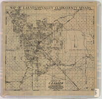
Map of Las Vegas Valley, Clark County, Nevada, October 1, 1940
Date
1940-10-01
Description
'Compiled by C.D. Baker, Civil Engineer, State Water Right Surveyor, Mineral Surveyor, Gen. Land Office, Las Vegas, Clark County, Nevada. Oct. 1, 1940.' Scale [ca. 1:48,000]. 1 in. to 4,000 ft. Cadastral map.
Image
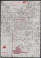
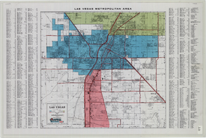
Map of metropolitan Las Vegas, Nevada, 1971
Date
1971
Description
At top of map: 'Avis Rent a Car System.' 'Copyright The H.M.Gousha Company... San Jose, Calif.' '8-SS-1044-S.' Scale [ca. 1:43,718]. 1 in. equals approx 0.69 miles. On verso: map of 'Las Vegas [and] Lake Mead Recreational Area, 1971 edition'; map of McCarran International Airport ('1274-S'); and list of Avis Rent A Car locations. H.M. Gousha Co.
Text
General map of Las Vegas, Nevada, June 1962
Date
1962-06
Description
At top of map: 'Las Vegas Metropolitan Area.' 'June 1962.' Includes indexes and information about Las Vegas. Published by Campbell Realty. Scale [ca. 1:31,680. 1 in. to approx. .5 miles].
Text

Surficial geologic map of Las Vegas Valley, Nevada, circa 1981
Date
1977 to 1985
Description
'United States Department of the Interior, Geological Survey. Open-file report, 84-130, plate 1.' 'Prepared in cooperation with the Clark County Department of Comprehensive Planning.' 'Base from U.S. Geological Survey 1:100,000, Boulder City, Ariz.-Nev., Las Vegas, Nev.-Calif., Mesquite Lake, Nev.-Calif., 1978, Lake Mead, Nev.-Ariz., 1979.'Geology from Malmberg (1965); Longwell and others (1965); Haynes (1967); Bingler (1977); Bell and Smith (1980); Bell (1981); Matti and Bachhuber (1982); and Matti and Morton (1982a and b); modified by R. W. Plume, 1981.' Shows township and range lines. Scale [ca. 1:102,960. 1 in.=approx. 1.625 miles] (W 115°30´--W 115°00´/N 36°30´--N 36°00´). Series: Open-file report (Geological Survey (U.S.))84-130. Originally published as plate 1 of Ground-water conditions in Las Vegas Valley, Clark County, Nevada. Part I. Hydrogeologic framework / by Russell W. Plume, published by the U.S. Geological Survey in 1984 as Open-file report 84-130.
Image
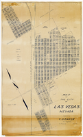
Map of the city of Las Vegas, Nevada, March 1, 1927
Date
1927-03-01
Description
'Compiled by C.D. Baker, civil eningeer. 220 Fremont St. March 1, 1927.' 'C.E. Pembroke, selling agent.' Scale [ca. 1:3,600]. 1 in. to 300 ft. Cadastral map. Blueline print.
Image
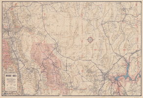
Map of desert area in southern Nevada and southeastern California, circa 1955
Date
1953 to 1957
Description
Covers the desert area in the Owens Valley, Death Valley, Las Vegas and Lake Mead region; bordered by Bishop and Inyokern, California, and Pioche and Lake Mead, Nevada. 'Cartography by W.T. Taylor, W.A. Neely. Color separation by H.P. Pflum; Relief by F.M. Burke; Typography by W.R. Williams. Field mapping by H.A. Cline, G.L. Boyd, K.R. Reed., W.A. Neely, R.P. Conklin.' 'Copyright by Automobile Club of Southern California.' Scale 1:483,537. 1 in. to approx. 8 miles (W 120°--W 114°/N 39°--N 33°). 'Map number 2217.'.
Text
Map of Tonopah Mining District, Nevada, circa 1905
Date
1900 to 1910
Description
Scale [ca.1:12,804. 1 in. to approx. 1,067 ft.] ; 1 map ; on sheet 92 x 106 cm ; Relief shown by hachures ; Title supplied by cataloger ; Probably a preliminary black and white edition of the colored map copyrighted by Bradford and Bradford in 1905 Bradford and Bradford.
Image

Map of Las Vegas Valley, Clark County, Nevada, October 1, 1940
Date
1940-10-01
Archival Collection
Description
'Compiled by C.D. Baker, Civil Engineer, State Water Right Surveyor, Mineral Surveyor, Gen. Land Office, Las Vegas, Clark County, Nevada. Oct. 1, 1940.' Yellow lines show boundary of the proposed water district; green lines show boundary of the city of Las Vegas; red line shows the Union Pacific Railroad route.
Image