Search Results

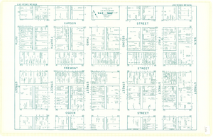
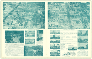
Map of downtown Las Vegas, Nevada, circa 1952-1955
Date
1952 to 1955
Description
Title in upper left and right margins: Las Vegas, Nevada. Identifies business tenants in the downtown area and includes property valuations, measurements, addresses, etc. Cadastral map. Oriented with north to the lower right.Text, illustrations, aerial photos, and ancillary map of the Las Vegas Strip on verso. Cataloger has determined date of map to be between 1952 and 1955 because the Sahara and the Sands Casinos are shown on the verso of the map, and they both opened in 1952, but the Riviera and the Dunes opened in 1955, and they are not shown on the map. Also, the Hotel Last Frontier is shown on the verso of the map, and its name was changed to New Frontier in 1955. Note: Many of the property names and addresses are erroneous when compared to Las Vegas business directories from the same period.
Image
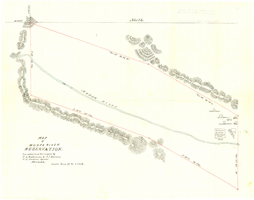
Map of Moapa River Reservation, located and surveyed by C. A. Bateman & A. J. Barnes, U.S. Indian agents, Nevada, 1875
Date
1875
Description
Scale 600 ft. to 1 inch. Relief shown by hachures. Shows buildings. Shows township and range grid. "Rec with Indian office letter June 10 1875. Copies sent to Sup. Gen. and R&R at Pioche Nevada August 9 1875" handwritten in blue ink on verso.
Image

Map of Moapa River Indian Reservation, TPS. 14 & 15 S., RS. 65 & 66 E., M.D.M., Nevada, 1902
Date
1902
Description
As surveyed by V. S. Barber, 1902. Scale = 15 chains to an inch. "H Doc 65 57 2" in lower right corner. Relief shown by hachures. Shows township and range grid.
Image
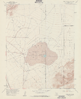
Topographic map of Frenchman Flat quadrangle, Nevada, 1960
Date
1960
Description
'Mapped, edited, and published by the Geological Survery in cooperation with the Atomic Energy Commission. Control by USGS, USC&GS, USCE, and Atomic Energy Commission. Topography from aerial photographs by photogrammetric methods. Aerial photographs taken 1959. Field check 1960.' Scale 1:24,000 polyconic projection (W 116°00'00"--W 115°52'30"/N 36°52'30"--N 36°45'00"). Series: 7.5 minute series (topographic). Relief shown by contours and spot heights. Filing title: Frenchman Flat, Nev. Contour interval 20 feet. opography rom . Includes quadrangle location map. Interior--Geological SurveyFor sale by the U.S. Geological Survey
Image
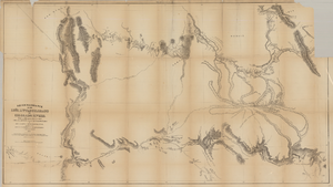
Map based on reconnaissance of the Zuñi, Little Colorado and Colorado Rivers in 1851 by U.S. Corps of Topographical Engineers
Date
1852
Description
Transcribed from the original: 'Made in 1851 under the direction of Col J.J. Abert, Chief of Corps Topographical Engineers, by BVT. Capt. L. Sitgreaves, T.E., assisted by Lieut. J.G. Parke, T.E., and Mr. M.H. Kern. Drawn by R.H. Kern, 1852.' 'Gila River from a reconnaissance by Maj. Emory, Topographical Engrs. Colorado River below Camp Yuma from a reconnaissance by Lt. Derby Topographical Engrs.' Shows Indian villages and forts. Upper right corner partially missing. Scale [ca. 1:650,000]. Scale of 10 miles to one inch.' 'Ackerman Lith.: 379 Broadway, N.Y.'
Image
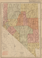
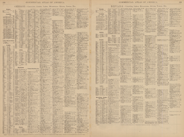
Rand-McNally new commercial atlas map of Nevada, 1912
Date
1912
Description
Original publisher: Rand, McNally & Co. Scale [ca. 1:1,203,840). 1 inch to 19 miles. Originally published as p. 316-317 of Rand McNally's commercial atlas of America. Title in right margin: Nevada : commercial atlas of America. Includes township and range grid. Includes index to Nevada railroads and index to principal cities with their populations. Index on verso to counties, towns and natural features in Oregon and Nevada.
Image