Search Results
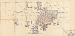
Map showing facilities of the Las Vegas Land and Water Co. completed, under construction and commenced after September 1, 1952
Date
1953-04-29
Description
'Exhibit D. Facilities of Water Company completed as of September 1, 1952. Facilities of Water Company under construction as of September 1, 1952. Facilities of Water Company which were commenced after September 1, 1952, and prior to March 1, 1954. April 29, 1953. I-67.'
Image
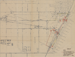
Map showing water pipelines to be sold to the Las Vegas Valley Water District, those to be retained by the Union Pacific Railroad Company, and privately owned pipelines, April 29, 1953
Date
1953-04-29
Description
'Exhibit H. Portions of pipe lines to be sold to the District. Pipe lines connecting to those to be sold to the District which will be retained by Railroad Companies. privately owned pipe lines. April 29, 1953. I-128.'
Image
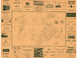
Street map of the city of Las Vegas, 1955
Date
1955
Description
20 x 35 cm., folded to 22 x 11 cm. Copyright held by Redwood Pub. Co. "Compliments of 'Buck' Evans 76 Union"--Panel. Index on verso. Includes table of mileages to Las Vegas from other cities in the Southwest. Original publisher: Redwood Publishing Co., Scale: .
Image
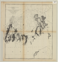
From the Great Salt Lake to the Humboldt Mountains
Date
1855
Description
'From explorations and surveys made under the direction of the Hon. Jefferson Davis, Secretary of War, by Capt. E.G. Beckwith, 3rd Artillery, E.G. Egloffstein, topographer for the route. 1855.' ''Selmar Siebert's Engraving & Printing Establishment, Washington, D.C.' Published by the War Dept. Scale 1:760,320. 12 miles to 1 in. Relief shown by hachures and spot heights.
Image
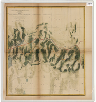
From the Humboldt Mountains to the Mud Lakes
Date
1855
Description
'From explorations and surveys made under the direction of the Hon. Jefferson Davis, Secretary of War, by Capt. E.G. Beckwith, 3rd Artillery, E.G. Egloffstein, topographer for the route. 1855.' ''Selmar Siebert's Engraving & Printing Establishment, Washington, D.C.' Proposed railroad lines highlighted in red. 'Line explored in 1854' highlighted in yellow. Published by the War Dept. Scale 1:760,320. 12 miles to 1 in. Relief shown by hachures and spot heights.
Image
From the valley of the Mud Lakes to the Pacific Ocean
Date
1855
Description
'From explorations and surveys made under the direction of the Hon. Jefferson Davis, Secretary of War, by Capt. E.G. Beckwith, 3rd Artillery, E.G. Egloffstein, topographer for the route. 1855.' ''Selmar Siebert's Engraving & Printing Establishment, Washington, D.C.' Proposed railroad lines highlighted in red and yellow. Published by the War Dept. Scale 1:760,320. 12 miles to 1 in. Relief shown by hachures and spot heights.
Image
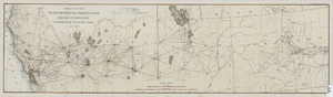
Map of the progress of the transcontinental triangulation and reconnaissance eastward from the Pacific Coast, June 30, 1883
Date
1883-06-30
Description
26 x 93 cm. "Coast and Geodetic Survey report, 1883, no. 23." "June 30, 1883." Original publisher: U.S. Coast and Geodetic Survey, Scale: 1: 2000 000.
Image
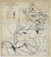
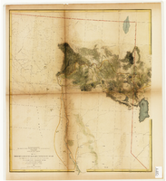
Map of Colorado River Basin, 1928
Date
1928
Description
52 x 46 cm. "Map no. 23000." Shows reservoir sites, irrigated areas, power plants, power sites, dam sites, national parks or monuments, and diversion from basin. Colorado River Basin/Department of the Interior, Bureau of Reclamation; John H. Pellen, chief draftsman. Original publisher: United States. Bureau of Reclamation.
Image

Map of California and territories of New Mexico and Utah, circa 1861
Date
1856 to 1866
Description
40 x 60 cm. Relief shown by hachures and spot heights. Prime meridians: Greenwich and Washington. Atlas plate numbers 54 and 55 in the upper corners. Shows forts, trails, exploration routes, drainage, mail steamship routes, physical features, Indian tribes, and historic sites. The geographic region of Southwest is referred to as the New Southwest. Original publisher: Johnson .
Image