Search Results
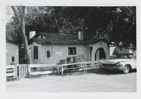
Photograph of a residential home in Las Vegas, Nevada, circa 1960s
Date
1960 to 1969
Archival Collection
Description
A residental home at 1628 Goldfield, Las Vegas, Nevada.
Image
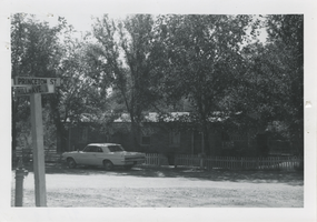
Photograph of a residential home in Las Vegas, Nevada, circa 1960s
Date
1960 to 1969
Archival Collection
Description
A residential home at 101-3 Hill Avenue at the corner of Princeton Street, Las Vegas, Nevada.
Image
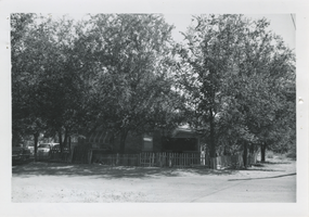
Photograph of a residential home in Las Vegas, Nevada, circa 1960s
Date
1960 to 1969
Archival Collection
Description
A residential home at 101-3 Hill Avenue, Las Vegas, Nevada.
Image
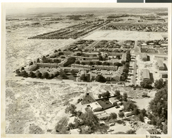
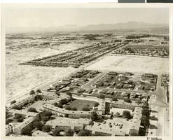
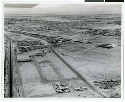
Aerial photograph of apartments and residential neighborhoods in North Las Vegas, Nevada, June 5, 1973
Date
1973-06-05
Archival Collection
Description
Aerial view of Northland Gardens apartments, North Las Vegas, Nevada (center of photograph), looking south from Las Vegas Boulevard North. Sandy Lane runs from southwest to northeast through the center of the photograph. Clifford Street appears in the center right. Housing subdivisions are seen in the background. Caption on back of photograph:"Project: Annex. area - land use; Location: Looking so. of LVBN; Remarks: Northland Garden Apt., Hol. PK., Americana."
Image
Aerial photograph of apartments and residential neighborhoods in North Las Vegas, Nevada, June 5, 1973
Date
1973-06-05
Archival Collection
Description
Aerial view of Northland Gardens apartments and surrounding neighborhoods, North Las Vegas, Nevada, looking southeast from around Geist Avenue. Sandy Lane runs from southwest to northeast through the center of the photograph. Clifford Street appears at the lower right. Caption on back of photograph: "Project: Land use, Sandy Lane, North Gardens in foreground, looking south; Americana on east side of Sandy"
Image
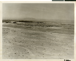
Aerial photograph of North Las Vegas, Nevada, June 5, 1973
Date
1973-06-05
Archival Collection
Description
Aerial view of housing developments in North Las Vegas, Nevada. Caption on back of photograph: "Project: Annex. area - land use. Location: Looking west. Remarks: Toward No. Hgh. Est. and Wishing Well."
Image
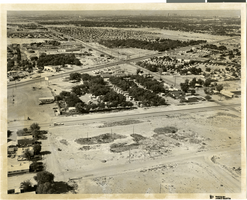
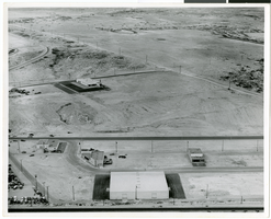
Aerial photograph of North Las Vegas, Nevada, June 5, 1973
Date
1973-06-05
Archival Collection
Description
Aerial view of North Las Vegas, Nevada, looking south from Las Vegas Boulevard North between North Pecos Road and Sandy Lane. Northland Gardens apartments are seen in the center of the photograph. Caption on back of photograph: "Project: Annex. area - land use. Location: Looking so. across, west on right L.V.B.N. toward Northland Gardens, Hol. Pk., Americana."
Image
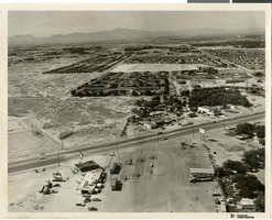
Aerial photograph of North Las Vegas, Nevada, June 5, 1973
Date
1973-06-05
Archival Collection
Description
Aerial view of North Las Vegas, Nevada, looking southwest from Cheyenne Avenue near North Pecos Road. Caption on back of photograph: "Project: Land use. Location: Cheyenne Ave., Las Vegas Blvd. No., Pecos (No. & So.)." Hotels in Las Vegas skyline are seen in distance in upper right.
Image
Aerial photograph of North Las Vegas, Nevada, June 5, 1973
Date
1973-06-05
Archival Collection
Description
Aerial view of housing developments in North Las Vegas, Nevada. Handwritten on back of photograph: "Crestline Loop - Losee Road."
Image
Aerial photograph of North Las Vegas, Nevada, June 5, 1973
Date
1973-06-05
Archival Collection
Description
Aerial view of housing developments in North Las Vegas, Nevada. Handwritten on back of photograph: "Regal Estates. Losee Road, Crestline Loop."
Image