
Search the Special Collections and Archives Portal

Search Results

Display    Results Per Page
Displaying results 11 - 17 of 17

Map of economic features, part of central New Mexico, May 7, 1877

Date

1877-05-07

Description

37 x 50 cm. Relief shown by hachures and spot heights "Atlas sheet no. 77(B)." "Issued May 7th 1877." "Expeditions of 1871 & 1786 under the command of 1st. Lieut. Geo. M. Wheeler, Corps of Engineers, U.S. Army." "Weyss, Herman & Lang, del." "By order of the honorable the Secretary of War." "Under the direction of Brig. General A. A. Hunphreys, Chief of Engineers, U. S. Army." "2nd. Ed. June 30th, 1881." Original publisher: U.S. Geographical Surveys West of the 100th Meridian, Scale: 1 inch to 4 miles or 1: 253440.

Image

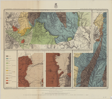
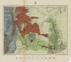
Map of Utah territory representing the extent of the irrigable, timber and pasture lands, 1878

Date

1878

Description

90 x 71 cm. Relief shown by hachures. In bottom margin: "Julius Bien, Lith." "Note. This map has been constructed from atlas sheets of the U.S. Geographical and Geological Survey of the Rocky Mountain Region with additional material taken from the maps of the U.S. Geographical Explorations and Surveys west of the 100th meridian, Lieut. Geo. M. Wheeler, Corps of Engineers, in charge ; the U.S. Geological Exploration of the 40th parallel, Clarence King, U.S. Geologist in charge ; and the U.S. Geologial and Geographical Survey of the Territories, F.V. Hayden, in charge." At head of title: Department of the Interior, U.S. Geographical and Geological Survey of the Rocky Mountain region, J.W. Powell in charge. Original publisher unknown.

Image

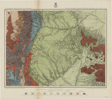
Map of part of North Central New Mexico atlas sheets 69(B), 69(D), 77(B) and 78(A), June 30, 1881

Date

1881-06-30

Description

39 x 52 cm. Relief shown by hachures and spot heights "Issued June 30, 1881." "Expeditions of 1873, 1878 and 1879 under the command of 1st. Lieut. Geo. M. Wheeler, Corps of Engineers U.S. Army." Geological map Probably originally published as part of the geological atlas which is an appendix to the Surveys' Report upon United States geographical surveys west of the one hundredth meridian. "Prof. John J. Stevenson, geological assistant." "By order of the honorable the Secretary of War under the direction of Brig. General A. A. Hunphreys, Chief of Engineers, U. S. Army." Original publisher: U.S. Geographical Surveys West of the 100th Meridian, Scale: 1 inch to 4 miles or 1: 253440.

Image

Map of parts of southern Colorado and northern New Mexico, atlas sheet no. 70(A), 1877

Date

1877-05-07

Description

37 x 50 cm. Prime meridian: Washington, D.C. Relief shown by hachures and spot heights. "Issued May 7th, 1877. 2nd ed., June 30th, 1881." "Atlas sheet no. 77(B)." "Expeditions of 1871 & 1786 under the command of 1st. Lieut. Geo. M. Wheeler, Corps of Engineers, U.S. Army." "Weyss, Herman & Lang, del." Probably originally published as part of the geological atlas which is an appendix to the Surveys' Report upon United States geographical surveys west of the one hundredth meridian. Geological map. "Prof. John J. Stevenson, geological assistant." Original publisher: U.S. Geographical Surveys West of the 100th Meridian, Scale: 1 inch to 4 miles or 1: 253440.

Image

Map of part of north central New Mexico, atlas sheet no. 70(C), May 7th, 1877

Date

1877-05-07

Description

39 x 50 cm. Relief shown by hachures and spot heights. "Issued May 7th 1877-2nd ed. June 30th, 1881." "Expeditions of 1878 and 1879 under the command of 1st. Lieut. Geo. M. Wheeler, Corp. of Engineers U.S. Army." "Weyss Herman & Lang Del." Prime meridians: Washington, D.C. and Greenwich Geological map Probably originally published as part of the geological atlas which is an appendix to the Surveys' Report upon United States geographical surveys west of the one hundredth meridian. "Prof. John J. Stevenson, geological assistant." "By order of the honorable the Secretary of War under the direction of Brig. General A. A. Hunphreys, Chief of Engineers, U. S. Army." Original publisher: U.S. Geographical Surveys West of the 100th Meridian, Scale: 1 inch to 4 miles or 1: 253440.

Image

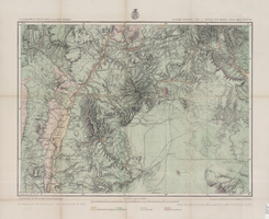
Map of part of central Colorado, May 7, 1877

Date

1877-05-07

Description

38 x 48 cm. Relief shown by hachures and spot heights. "Atlas sheet no. 53(C)." "Issued May 7th 1877." "1st. Lieut. Geo. M. Wheeler, Corps of Engineers, U.S. Army." Prime meridians: Greenwich and Washington, D.C. Includes sectional diagram that shows how atlas sheets fit together. "Weyss, Herman & Lang, del." "Louis Nell, J. J. Young, topographical assistants." "Under the direction of Brig. General A. A. Hunphreys, Chief of Engineers, U. S. Army." "Expeditions of 1873 and 1876 under the command of 1st. Lieutenant William L. Marshall, Corps of Engineers, U. S. Army, 1st Lieutenant Eric Bergland, Corps of Engineers, U. S. Army, Executive Officers and field astronomers." "By order of the honorable the Secretary of War." Original publisher: Graphic Co. photo., Scale: 1 inch to 4 miles or 1:253440.

Image

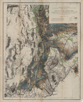
Map of part of south western Colorado, January 10, 1878

Date

1878-01-10

Description

38 x 49 cm. Relief shown by hachures and spot heights. "Atlas sheet no. 61(D)." "Issued Jan. 10th 1878." "Expeditions of 1873, 74, 75 & 76 under the command of 1st. Lieut. Geo. M. Wheeler, Corps of Engineers, U.S. Army." Prime meridians: Washington, D.C. and Greenwich. Includes sectional diagram showing how atlas sheets fit together. "Weyss, Lang & Herman, del." "By order of the honorable the Secretary of War." "Under the direction of Brig. General A. A. Hunphreys, Chief of Engineers, U. S. Army." " J. C. Spiller, Louis Nell, topographical assistants." "Expeditions of 1873, 74, 75 & 76 under the command of 1st. Lieutenant William L. Marshall, Corps of Engineers, U. S. Army, 1st Lieutenant Eric Bergland, Corps of Engineers, U. S. Army, Executive Officers and field astronomers." Original publisher: U.S. Geographical Surveys West of the 100th Meridian, Scale 1 inch to 4 miles or 1:253440.

Image