
Search the Special Collections and Archives Portal

Search Results

Display    Results Per Page
Displaying results 21 - 30 of 37

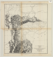
From the valley of Green River to the Great Salt Lake

Date

1855

Description

'From explorations and surveys made under the direction of the Hon. Jefferson Davis, Secretary of War, by Capt. E.G. Beckwith, 3rd Artillery, E.G. Egloffstein, topographer for the route. 1855.' ''Selmar Siebert's Engraving & Printing Establishment, Washington, D.C.' Published by the War Dept. Scale 1:760,320. 12 miles to 1 in. Relief shown by hachures and spot heights.

Image

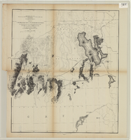
From the Great Salt Lake to the Humboldt Mountains

Date

1855

Description

'From explorations and surveys made under the direction of the Hon. Jefferson Davis, Secretary of War, by Capt. E.G. Beckwith, 3rd Artillery, E.G. Egloffstein, topographer for the route. 1855.' ''Selmar Siebert's Engraving & Printing Establishment, Washington, D.C.' Published by the War Dept. Scale 1:760,320. 12 miles to 1 in. Relief shown by hachures and spot heights.

Image

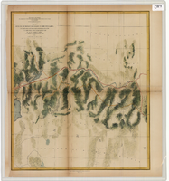
From the Humboldt Mountains to the Mud Lakes

Date

1855

Description

'From explorations and surveys made under the direction of the Hon. Jefferson Davis, Secretary of War, by Capt. E.G. Beckwith, 3rd Artillery, E.G. Egloffstein, topographer for the route. 1855.' ''Selmar Siebert's Engraving & Printing Establishment, Washington, D.C.' Proposed railroad lines highlighted in red. 'Line explored in 1854' highlighted in yellow. Published by the War Dept. Scale 1:760,320. 12 miles to 1 in. Relief shown by hachures and spot heights.

Image

From the valley of the Mud Lakes to the Pacific Ocean

Date

1855

Description

'From explorations and surveys made under the direction of the Hon. Jefferson Davis, Secretary of War, by Capt. E.G. Beckwith, 3rd Artillery, E.G. Egloffstein, topographer for the route. 1855.' ''Selmar Siebert's Engraving & Printing Establishment, Washington, D.C.' Proposed railroad lines highlighted in red and yellow. Published by the War Dept. Scale 1:760,320. 12 miles to 1 in. Relief shown by hachures and spot heights.

Image

Plat showing original townsite and subdivisions, Las Vegas, Lincoln County, Nevada, May 1905

Date

1905-05

Description

Land owned by the San Pedro, Los Angeles & Salt Lake Railroad is outlined. Scale: [ca. 1:12,000]. 1 inch = 1,000 feet. Cadastral map. Blueline print. Additional copy available in the J.T. McWilliams manuscript collection

Image

Original plat, townsite of Las Vegas, Lincoln Co., Nevada, January 13, 1905

Date

1905-01-13

Description

Subtitle: 'Embracing the N. 1/2 of S.W. 1/4 Sec. 27 Township 20S. R.61E. Mt. Diablo Meridian.' 'Book 1, page 17A" handwritten in lower right corner. Signed by Henry Lee, County Recorder, Lincoln County Nevada. 'Filed at request of J.T. Williams, January 13th A.D. 1905.' Backwards handwriting on right side. Map has a Lincoln County seal on the bottom near the center. In the dedication J.T. McWilliams states that he has surveyed and platted the townsite of Las Vegas subject to the right of way of the San Pedro, Los Angeles and Salt Lake Railroad Company. He signed the dedication on Jan. 13, 1905, and it was signed by witnesses Scale [ca. 1:2,520? 1 inch to approx. 210 feet?]. Copy of a blueline print.

Image

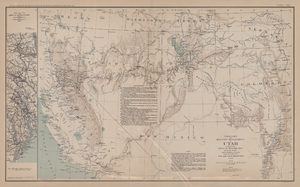
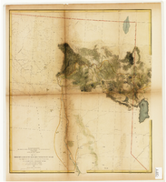
Map of territory and military department of Utah, 1860

Date

1860

Description

Compiled in the Bureau of Topographical Engineers of the War Department. Chiefly for Military purposes under the authority of Honorable J.B. Floyd, Secretary of War, 1860. 42 x 69 cm. Shows towns, wagon roads, explorers' routes, railroads, forts, etc., approx. from Albuquerque, N.M. to Fort Lane, Or. and from Fort Laramie, Wyo. to Los Angeles, Calif. "Corrections and additions in reference to railroads in California, etc., were made in January, 1862 ..." "The new military posts at Fort Bidwell, ... located from a map loaned ... January 16, 1866." "Atlas to accompany the official records of the Union and Confederate armies, 1861-1865. Plate CXX."--Upper margin. Atlas published by the Washington Government Printing Office in 1891-95. Relief shown by hachures. "Julius Bien & Co. Lith. N.Y." Includes text and list of authorities. Inset: March routes of Army of the Tennessee from Savannah, Ga., to Columbia, S.C., 1865, accompanying the report of Maj. Gen O.O. Howard, U.S. Army, series I, vol. XLVII, part I. Includes bibliographical references. Washington Territory is shown prior to becoming Washington state. The geographic region of Southwest is referred to as the New Southwest. Original publisher: Govt. Print. Off..

Image

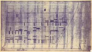
Plat of original townsite of Las Vegas, Clark County, Nevada, November 25, 1927

Date

1927-11-25

Description

Subtitle: 'On N 1/2 of SW 1/4 section 27, T 20 S, R 61 E, M.D. Mer. showing cast iron water mains. Including location and distances of valves, fire hydrants, house connections, etc. Constructed by Las Vegas Land &Water Company. Construction completed Nov. 25-1927. Cast iron pipe system throughout made at Provo, Utah by Pacific States Cast Iron Pipe Company. R.N. Clark, Construction Engineer. Map and survey made by J.T. McWilliams, C.E., Las Vegas, Nev.' Map shows ownership of some parcels of land. Scale [ca. 1:960]. 1 inch to 80 feet. Blueline print. Plat map.

Image

Longitudinal section map, Montana Tonopah Mine, circa 1900s-1910s

Date

1900 to 1919

Description

'Longitudinal Section, Montana Tonopah Mine showing workings projected on east-west vertical plane.' In lower right corner: 'E.D. North E.M.' 'Photo-litho. Britton & Rey, S.F.'

Image

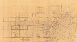
Map of Las Vegas showing areas owned by the Union Pacific Railroad Company, water pipes and other water utilities, circa 1942

Date

1938 to 1946

Description

Map showing downtown Las Vegas and tracts to the west showing water supply lines, wells, springs, and settling basins. Various areas outlined in red and yellow. Scale [ca. 1:7,200] 1 in.=600 feet. Cadastral map. Blueline print. Areas owned by railroad outlined by hand in different colored markers. Library's copy includes hand-written calculations.

Image