Search the Special Collections and Archives Portal
Search Results

Letter from Walter R. Bracken (Las Vegas) to E. E. Calvin (Omaha), November 2, 1921
Date
Archival Collection
Description
Details about a new well on Union Pacific Railroad property.
Text

Letter from J. Ross Clark to R. E. Wells, February 16, 1912
Date
Archival Collection
Description
Discussion of the necessity of someone patrolling the Las Vegas Springs for security.
Text
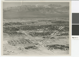
Aerial photograph of the Las Vegas Valley looking northwest towards Mount Charleston, 1945
Date
Archival Collection
Description
Aerial view of the Las Vegas Valley looking northwest towards Mount Charleston.
Transcribed Notes: Handwritten inscription on back: Las Vegas about 1945 looking toward Charleston Mountains (North West). Road intersection in immediate foreground is that of Fremont Street from the right, Charleston Blvd from the left (Charleston Blvd runs due West); Stamped on back: Las Vegas News Bureau, Las Vegas - Nevada, Photographers Don English - Joe Buck - Jerry Abbott
Image
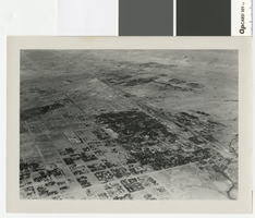
Aerial photograph of Las Vegas, full view of high school, southwest direction, 1930
Date
Archival Collection
Description
Aerial view of Las Vegas in 1930
Transcribed Notes: Notes on back of duplicate photo: Aerial view of Las Vegas w/ new high school on bottom left, c. 1933; Notes on photo sleeve: Aerial view of Las Vegas taken in the winter of 1930 (same day as #0123 002) in clip wing Jenny. Shows railroad and main street - essentially shows the whole city. (Credit: W.A. Davis)
Image
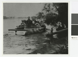
Photograph of the Arivada Ferry, 1916-1920
Date
Archival Collection
Description
Arivada Ferry, owned by Jim Cashman and operated by Pop Emery. Its primary purpose was to provide a way for Arizonans to get to Nevada where prohibition was not as strictly enforced.
Transcribed Notes: Transcribed from photo sleeve: "Arivada Ferry, 1916-1920. This ferry was owned by Jim Cashman and operated by Pop Emery (standing, in picture). Originally located at the upper end of Cottonwood Island, a few miles below where the Cottonwood Cove Resort is located, it was later moved due to lack of business to TriState, Nevada, where it served for a short time between the Katherine Mine in Arizona and the TriState Mine in Nevada. Its main purpose here was to provide a way for Arizonans to get to Nevada where prohibition laws were not strictly enforced."
Image

Photograph of a drill rig putting down the hole for the first well in the Las Vegas Heights District, circa 1907
Date
Archival Collection
Description
Drilling in the Las Vegas Heights District with Mr. Booth and Mr. Madison performing the work.
Transcribed Notes: Transcribed from front of photo: "1st well. Vegas Hts. About 1907. Booth & Madison, Drillers."; Transcribed from photo sleeve: "A drill rig which put down the hole for the first well in the Las Vegas Heights District in Las Vegas in 1907. The crew were Booth and Madison."
Image

Aerial photograph of Las Vegas, looking east down Fremont Street, circa late 1940s
Date
Archival Collection
Description
Aerial view of Las Vegas, looking east down Fremont Street. Jackie Gaughan's Plaza was originally named Union Plaza and is currently called the Plaza Hotel and Casino.
Transcribed Notes: Transcribed from back of photo: "Fremont Street in downtown Las Vegas as it appeared in the late 1940s. In the foreground stands the Union Pacific Depot where Jackie Gaughan's Plaza stands today."
Image

Photograph of flood channel west of Interstate 15 looking toward North Las Vegas, June 5, 1973
Date
Archival Collection
Description
Flood channel west of Interstate 15 looking toward North Las Vegas and Frenchman Mountain.
Transcribed Notes: Notes on back: "Flood Channel west of I-15 looking towards NLV and Sunrise Mountain." Stamped on back: "CNLV Engineering Dept."
Image
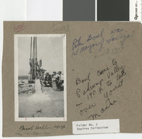
Mounted photograph of Peter Buol next to his artesian well in the Las Vegas Valley, 1914
Date
Archival Collection
Description
Peter Buol, first mayor of Las Vegas, and two other men next to a drilling rig and a flowing artesian well. Photograph was mounted on cardboard.
Transcribed Notes: Transcribed from cardboard mount: "Peter Boul (sic) was 1st Mayor of Las Vegas; Died 1964; Boul (sic) came to Pahrump Valley in 1904 to take over Yount Manse; Buol Well - 1914."
Image
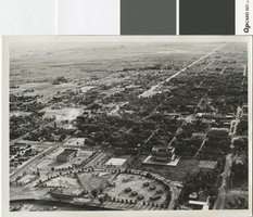
Aerial photograph of Las Vegas in the mid to late 1930s
Date
Archival Collection
Description
Aerial photo of Las Vegas looking south.
Transcribed Notes: Transcribed from photo sleeve: "[L. Foreground, old city hall. R. foreground, post office. Circular Park w/Boy scout structures (7)] "Aerial view of Las Vegas shows old park with race track (about where municipal swimming pool is) Small huts in group were Boy Scout huts made of stone. Scout troups met here surrounded by park taken middle or late 30's."- Dave Coons"
Image
