
Search the Special Collections and Archives Portal

Search Results

Display    Results Per Page
Displaying results 61 - 70 of 128

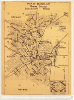
Map of Searchlight mining district, Clark County, Nevada, circa 1905

Date

1901 to 1909

Description

At bottom right of map: 'C.D. Baker, A.R. Thompson.' Title in lower right corner: 'Map of Searchlight mining district: mineral patents, water rights.' Logo of Nevada Engineering Construction Service, Inc., Las Vegas, Nev. in lower right corner. Blueline print. Shows mineral patents and water rights. Nevada Engineering & Construction Service, Inc.

Image

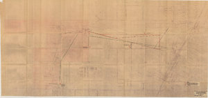
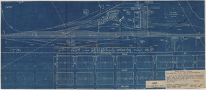
Map showing location of proposed 12-inch water main to connect Well #8 with settling basin serving Reservoir No. 2 at Las Vegas, Nevada, January 16, 1950

Date

1950-01-16

Description

'Office of Manager-Industrial Development, Los Angeles, California.' Scale: 1" = 600'. 10 3/8 in. x 8 in.

Image

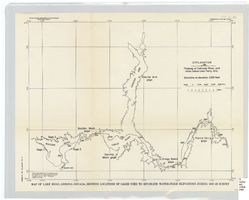
Map of Lake Mead, Arizona-Nevada, showing locations of gages used to establish water-stage elevations during 1947-49 survey

Date

1960

Description

Scale [ca. 1:274,349. 1 in. to approx. 4.33 miles] (W 114°54?--W 113°54?/N 36°36?--N 35°58?). 1 map ; 27 x 34 cm. United States Dept. of the Interior, Geological Survey

Image

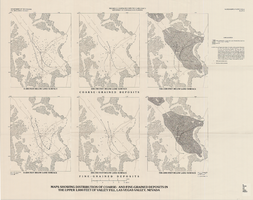
Maps showing distribution of coarse- and fine-grained deposits in the upper 1,000 feet of valley fill, Las Vegas Valley, Nevada, 1981 (Water-supply paper 2320-A, plate 3)

Date

1981

Description

'Department of Interior, U.S. Geological Survey. Water-supply paper 2320-A, plate 3.' 'Prepared in cooperation with the Clark County Department of Comprehensive Planning.' 'Base from U.S. Geological Survey, 1:250,000, Las Vegas and Kingman, 1969.' 'Geology from Malmberg (1965); Longwell and others (1965); and J. R. Harrill, 1976. Lithology by R.W. Plume, 1981.' Contents: Coarse-grained deposits: 0-200 feet below land surface; 200-700 feet below land surface; 700-1,000 feet below land surface -- Fine-grained deposits: 0-200 feet below land surface; 200-700 feet below land surface; 700-1,000 feet below land surface. Scale [ca. 1:316,800. 1 in.=approx. 5 miles]. Series: U.S. Geological Survey water-supply paper2320-A. Originally published as plate 3 of Ground-water conditions in Las Vegas Valley, Clark County, Nevada. Part I. Hydrogeologic framework / by Russell W. Plume, published by the U.S. Geological Survey in 1989 as Water-supply paper 2320-A.United States Dept. of the Interior, Geological Survey.

Image

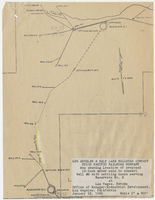
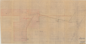
Map to accompany joint letter dated April 20th, 1931 to Mr. Gray concerning construction of proposed water main to serve lessees in Industrial Unit No. 1, Las Vegas, Nevada, April 20, 1931

Date

1931-04-20

Description

'Union Pacific System. Los Angeles & Salt Lake Railraod Company.' 'Office of Industrial Engr., Los Angeles, California, April 20th, 1931. Dwg. No. 588.' Scale: 1" = 200'.

Image

General geologic map of Las Vegas, Pahrump, and Indian Spring Valleys, Clark and Nye Counties, Nevada, 1948

Date

1948

Description

At top of map: 'United States Department of the Interior, Geological Survey. State Engineer of Nevada. Water resources bulletin No. 5, Plate 1.' Relief shown by spot heights. Includes 3 inset maps of wells and springs in the vicinity of Pahrump, Manse Ranch and Indian Springs, Nevada. Scale [ca. 1:126,720. 1 inch to approx. 2 miles] (W 116°--W 115°/N 40°--N 36°). Originally published as plate 1 in Geology and water resources of Las Vegas, Pahrump, and Indian Spring Valleys, Clark and Nye Counties, Nevada by George B. Maxey and C.H. Jameson (1948), which is number 5 of the Water resources bulletin published by the Nevada Office of the State Engineer.

Image

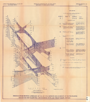
Fence diagram showing lithology of valley-fill deposits and summary of water-bearing properties for valley-fill and bedrock units, Las Vegas Valley, Nevada, 1981 (Open-file report 84-130)

Date

1981

Description

'United States Department of the Interior, Geological Survey. Open-file report 84-130, plate 2.' 'Prepared in cooperation with the Clark County Department of Comprehensive Planning.' 'Geology by R.W. Plume, 1981.' Scale [ca. 1:31,680. 1 in.=approx. .5 miles]. . Series: Open-file report (Geological Survey (U.S.))84-130. Originally published as plate 2 of Ground-water conditions in Las Vegas .Valley, Clark County, Nevada. Part I. Hydrogeologic framework / by Russell W. Plume, published by the U.S. Geological Survey in 1984 as Open-file report 84-130. "Prepared in cooperation with the Clark County Department of Comprehensive Planning."

Text

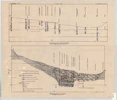
Cross-sections of wells and aquifers in the Las Vegas Valley, circa 1946

Date

1943 to 1949

Description

2 map sections on 1 sheet. Originally published as plate 6 in Geology and water resources of Las Vegas, Pahrump, and Indian Spring Valleys, Clark and Nye Counties, Nevada by George B. Maxey and C.H. Jameson, which is number 5 of the Water resources bulletin published by the Nevada Office of the State Engineer. Shows permeable and impermeable materials, wells, and aquifers.

Text