
Search the Special Collections and Archives Portal

Search Results

Display    Results Per Page
Displaying results 51 - 60 of 128

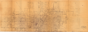
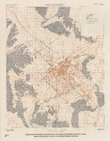
Topographic map of Las Vegas Rancho, showing location of wells and water lines, Las Vegas, Nev., October 18, 1946

Date

1946-10-18

Description

'May 1, 1940. Revised Oct. 18, 1946.' 'F-225.' Relief shown by contours. Scale [ca. 1:7,200] 1 in.=600 feet.

Image

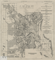
Map of Las Vegas artesian basin, Clark County, Nevada, April 1946 (Water Resources Bulletin no. 5, plate 5)

Date

1946-04

Description

'April, 1946.' 'Showing location of wells, springs, and boundary between valley fill and bedrock.' At top of map: 'United States Department of Interior, Geological Survey. Water resources bulletin no. 5, plate 5. ' 'State Engineer of Nevada.' At bottom of map: 'Map showing soils, land classification, and alkali concentration in part of Las Vegas Valley.' Includes range and township grid. Scale [ca. 1:71,597. 1 in. to approx. 1.13 miles]. Series: Water resources bulletin (Carson City, Nev.), no. 5. Originally published as plate 5 in Geology and water resources of Las Vegas, Pahrump, and Indian Spring Valleys, Clark and Nye Counties, Nevada by George B. Maxey and C.H. Jameson, which is number 5 of the Water resources bulletin published by the Nevada Office of the State Engineer.

Image

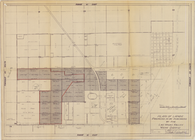
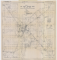
Map to accompany Appraisal of water lands of Los Angeles & Salt Lake Railroad Company, Las Vegas, Nevada, August 19, 1952

Date

1952-08-19

Description

'Office of General Land and Tax Agent, Los Angeles, California, August 19, 1952.' 'Parcels numbered as shwon on Water District map.' Scale: 1" = 600'.

Image

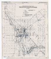
Map of part of Las Vegas Valley showing contours of the composite piezometric surface during the spring of 1944, and specific capacities of wells tapping the confined water

Date

1948

Description

Relief shown by contours. Includes range and township grid. Shows springs and wells. Scale [ca. 1:67,162. 1 in. to approx. 1.06 miles]. Series: Water resources bulletin (Carson City, Nev.)
no. 5. Originally published as plate 8 in Geology and water resources of Las Vegas, Pahrump, and Indian Spring Valleys, Clark and Nye Counties, Nevada by George B. Maxey and C.H. Jameson, which is number 5 of the Water resources bulletin published by the Nevada Office of the State Engineer.

Image

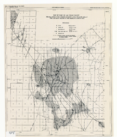
Map of part of Las Vegas Valley showing the piezometric surface of the "near-surface" water during the spring of 1946 by contours, and areas of discharge by evaporation and transpiration

Date

1946

Description

Relief shown by contours. Includes range and township grid. Shows springs, wells and areas of discharge. Scale [ca. 1:67,162. 1 in. to approx. 1.06 miles]. Series: Water resources bulletin (Carson City, Nev.)
no. 5. Originally published as plate 7 in Geology and water resources of Las Vegas, Pahrump, and Indian Spring Valleys, Clark and Nye Counties, Nevada by George B. Maxey and C.H. Jameson, which is number 5 of the Water resources bulletin published by the Nevada Office of the State Engineer.

Image

Map of Las Vegas artesian basin, Clark County, Nevada, April 1946 (Water Resources Bulletin no. 4, plate 1)

Date

1946-04

Description

'April, 1946.' 'Showing location of wells, springs, and boundary between valley fill and bedrock.' Originally published as plate 1 in number 4 of the Water resources bulletin published by the Nevada Office of the State Engineer. Scale [ca. 1:63,360. 1 in. to approx. 1 mile] (W 115°10?--N 115°/N 36°20?--N 36°). G4354.L3C34 1946 .N482

Image

Map of well locations, Las Vegas Valley, Nevada, 1975

Date

1976

Description

'Cartography by Marj Thielke.' 'Prepared in cooperation with the State of Nevada, Department of Conservation and Natural Resources, Division of Water Resources.' Relief shown by contours. Shows township and range lines. Originally published as Plate 1 in Water-level changes associated with ground-water development in Las Vegas Valley, Nevada, 1971-75 : fourth progress report--summary of data / by James R. Harrill, published in 1976 by the Department of Conservation and Natural Resources, Division of Water Resources, as volume 22 of Water resources-information series report. Scale [ca. 1:69,696. 1 in.=approx. 1.1 miles] (W 115°20´--W 115°00´/N 36°20´--N 36°00´).

Image

Index map showing locations of geologic sections on plate 2 and wells on plates 2 and 3, Las Vegas Valley, Nevada, 1981 (Water-supply paper 2320-A)

Date

1981

Description

'Department of the Interior, U.S. Geological Survey. Water-supply paper 2320-a, plate 4.' 'Prepared in cooperation with the Clark County Department of Comprehensive Planning.' 'Base from U.S. Geological Survey 1:100,000 , Boulder City, Ariz.-Nev., Las Vegas, Nev.-Calif., Mesquite Lake, Nev.-Calif., 1978, Lake Mead, Nev.-Ariz., 1979.' 'Geology from Malmberg (1965); Longwell and others (1965); Bell and Smith (1980); and J. R. Harrill, 1976.' Shows township and range lines. Scale 1:100,000 (W 115°30´--W 115°00´/N 36°30´--N 36°00´). Series: U.S. Geological Survey water-supply paper2320-A. Originally published as plate 4 of Ground-water conditions in Las Vegas Valley, Clark County, Nevada. Part I. Hydrogeologic framework / by Russell W. Plume, published by the U.S. Geological Survey in 1989 as Water-supply paper 2320-A.

Image

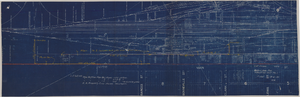
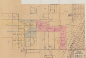
Map showing possible industrial users' connections to railroad pipelines in Las Vegas, Nevada, December 4, 1930

Date

1930-12-04

Description

Stamped portion near lower right corner reads 'Union Pacific System, L.A. & S.L. R.R. Scale: 1" = 100'. Date: 12-4-30. Office Division, Eng'r. Los Angeles. Drg. No. 916.' 10 3/4 in. x 33 3/4 in. Scale: 1" = 100"..

Image