Search Results
Map showing locations of water bearing lands to be sold to the Las Vegas Valley Water District and boundaries of lands owned by the Union Pacific Railroad not to be sold to the District, April 29,1953
Date
1953-04-29
Description
'Exhibit A. Location of water bearing lands to be sold to the District. Boundary of lands owned by Union Pacific which are not to be sold to the District. April 29, 1953. I-128'
Image
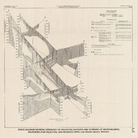
Fence diagram showing lithology of valley-fill deposits and summary of water-bearing properties for valley-fill and bedrock units, Las Vegas Valley, Nevada, 1981 (Water-supply paper 2320-A)
Date
1981
Description
'Department of the Interior, U.S. Geological Survey. Water-supply paper 2320-A, plate 2.' 'Prepared in cooperation with the Clark County Department of Comprehensive Planning.' 'Geology by R.W. Plume, 1981.' Scale [ca. 1:95,040. 1 in.=approx. 1.5 miles]. Series: U.S. Geological Survey water-supply paper2320-A. Originally published as plate 2 of Ground-water conditions in Las Vegas Valley, Clark County, Nevada. Part I. Hydrogeologic framework / by Russell W. Plume, published by the U.S. Geological Survey in 1989 as Water-supply paper 2320-A. "Prepared in cooperation with the Clark County Department of Comprehensive Planning."
Text
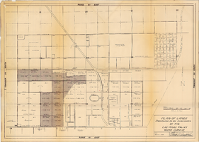
Plan of lands proposed to be purchased by the Las Vegas Valley Water District, August 1, 1952
Date
1952-08-01
Archival Collection
Description
'Date: August 1, 1952. Approved, Thomas A. Campbell, Pres.' Scale: [1 in.=approx. 300 feet]. Library's copy 2 has additional areas shaded, with original shaded areas outlined in red, plus various handwritten notations in pencil.
Image
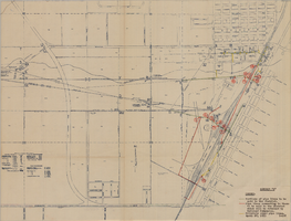
Map showing water pipelines to be sold to the Las Vegas Valley Water District, those to be retained by the Union Pacific Railroad Company, and privately owned pipelines, April 29, 1953
Date
1953-04-29
Description
'Exhibit H. Portions of pipe lines to be sold to the District. Pipe lines connecting to those to be sold to the District which will be retained by Railroad Companies. privately owned pipe lines. April 29, 1953. I-128.'
Image

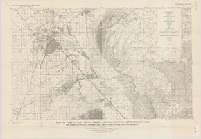
Map of the Las Vegas ground-water basin, Clark, Nye, and Lincoln Counties, Nevada, 1965
Date
1965
Description
At top of map: 'United States Department of the Interior, Geological Survey. Water-supply paper 1780, plate 1.' At bottom of map: 'Base from Army Map Service sheets NJ 11-9, NJ 11-12, and NI 11-3 (1947).' 'Boundary between bedrock and alluvium in Clark County, Nev., compiled by Ben Boyer, E. H. Pampeyan and C. R. Longwell. In Lincoln and Nye Counties, contact determined from aerial photographs.' 'Interior--Geological Survey, Washington, D.C.--1965--W63358.' Includes township and range lines.Relief shown by contours. Thematic map. Scale 1:250,000 (W 116°--W 114°45´/N 37°00´--N 35°30´). Series: Water-supply paper (Washington, D.C.), 1780. Originally published as plate 1 of Available water supply of the Las Vegas ground-water basin, Nevada, by Glenn T. Malmberg, published by the Geological Survey in 1965 as its Water-supply paper 1780.
Image
Map of part of Las Vegas Valley, Nevada, showing the approximate altitude of the water table in the near-surface reservoir in February 1956
Date
1965
Description
Genre/Form: Thematic maps. Scale 1:62,500 (W 115°15´--W 115°00´/N 36°15´--N 36°00´). 1 map ; 45 x 36 cm. Series: Water-supply paper (Washington, D.C.) ; 1780. Relief shown by contours. Originally published as plate 8 of Available water supply of the Las Vegas ground-water basin, Nevada, by Glenn T. Malmberg, published by the Geological Survey in 1965 as its Water-supply paper 1780. Includes township and range lines. Interior, Geological Survey
Image
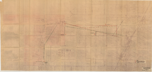
Map showing location of proposed water mains to serve Hyde Park Subdivision No. 2 at Las Vegas, Nevada, April 21, 1953
Date
1953-04-21
Archival Collection
Description
'Drawing B-617.' 'Office of Vice President, Los Angeles,California.' Accompanies: L. R. Maag letter to Thomas A. Campbell, June 15, 1953 (Box 14 Folder W26 File No. 1).
Image
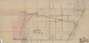
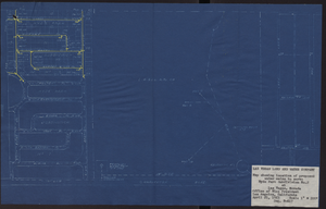
Map showing proposed relocation or removal of existing water transmission mains and power lines at Las Vegas, Nevada, June 3, 1952
Date
1952-06-03
Archival Collection
Description
'Los Angeles & Salt Lake Railroad Company. Union Pacific Railroad Company. Office of Vice President, Los Angeles, California, June 3, 1952.' 'Dwg. I-128.' Also shows location of land area proposed to be sold to the Las Vegas Valley Water District. Shows other parts of the water system and lists power requirements for water system. Includes township and range lines. Scale [ca. 1:3,600]. 1 in.=300 feet. Library's copy 2 is missing compass on right edge of page and has 'Limits of land which District proposes to buy, 507 Ac.' hand-printed in pencil and area is outlined in red.
Image
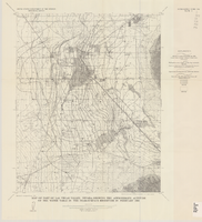
Map of part of Las Vegas Valley, Nevada, showing approximate area of phreatophytes before ground-water development
Date
1965
Description
Genre/Form: Thematic maps. Scale 1:62,500 (W 115°15´--W 114°45´/N 36°15´--N 36°00´). 1 map : col. ; 44 x 72 cm. Series: Water-supply paper (Washington, D.C.) ; 1780. Relief shown by contours. Originally published as plate 10 of Available water supply of the Las Vegas ground-water basin, Nevada, by Glenn T. Malmberg, published by the Geological Survey in 1965 as its Water-supply paper 1780. Includes township and range lines. Interior, Geological Survey
Image

Map showing profile of 24-inch cast iron water pipeline for Las Vegas, Nevada, May 20, 1930
Date
1930-05-20
Archival Collection
Description
'As constructed. Drawing W.O. - 8577. Office of Chief Engineer, Los Angeles. Drawing No. 41092.' 'Scale for details 1"=10'. 5-20-1930. P.F.D.' 'Scale 1"=100'.' 'Profile of new 24" CI pipe. Scale 1"=600'. Ver. 1"=20'.' Blueprint. Map of the water pipes for Las Vegas. Includes the buildings in the railroad yard, a detailed map of a section of the pipe, a profile of the 24 inch C.I. pipe, and a map of the point of diversion. Date of detailed map is 5-20-1930. Library's copy has hand-written additions in color. Los Angeles & Salt Lake Railroad Co., Office of Chief Engineer,
Image