Search Results
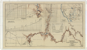
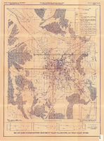
Topographic map of the Boulder Canyon Reservoir site, 1930
Date
1930
Description
Scale [ca. 1:144,000. 1 in. to approx. 12,000 ft.] ; 1 map : col. ; 51 x 91 cm ; Relief shown by contours and spot heights ; "Map no. 23800" ; Includes township and range grid ; Includes two profile diagrams, area and capacity curve diagram, Topography of Black Canyon and vicinity map and Colorado River basin map. Inset maps of Black Canyon and vicinity and Colorado River Basin. Inset charts of Boulder Canyon Reservoir Area and Capacity Curves; and, Profile of Colorado River from Bridge Canyon Dam Site, Arizona to Black Canyon Dam Site, Arizona-Nevada. Bureau of Reclamation.
Image
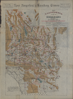
Map of California and Nevada deserts, 1905
Date
1905
Description
'Compiled by G.E. Bailey, E.M. Issued under the auspices of the the Los Angeles Chamber of Commerce and the supervision of its mining committee, Dan Murphy, H.Z. Osborne, Geo. W. Parsons, F.W. Braun, O.P. Posey, 1905.' 'A carefully prepared and authentic map of the desert mining region tributary of Los Angeles, embracing portions of Lincoln, Nye and Esmeralda counties, Nevada, showing location of all water supplies.' At top of page: 'Desert map. California-Nevada'. 'Miner's guide. Springs and waterholes.' Relief shown by hachures. Shows range and township grid. Scale indeterminable (W 119°--W 114°/N 37°--N 33°).
Image

Hydrogeologic map of Nevada Test Site and vicinity, southern Nevada, 1965
Date
1965
Description
At top of map: ' United States Department of the Interior, Geological Survey. Professional paper 712-C, plate 1. Prepared on behald of the U.S. Atomic Energy Commission.' At bottom of map: 'Base from U.S. Geological Survey, Caliente, Death Valley, Goldfield and Las Vegas, 1954. 100,00-foot grid based on Nevada coordinate system, central zone.' 'Hydrogeology by I. J. Winograd, 1965; geology by William Thordarson.' Relief shown by contours and spot heights. Shows township and range lines. Includes diagram of downward and upward cross-flow of water. Includes bibliographical references and index. Contour interval 200 feet. Scale 1:250,000 (W 117°--W 115°/N 38°--N 36°). Series: Professional paper (Geological Survey (U.S.), 712-C. Issued as plate 1 from Hydrogeologic and hydrochemical framework, south-central Great Basin, Nevada-California with special reference to the Nevada Test Site. Prepared on behalf of the U.S. Atomic Energy Commission by Isaac J. Winograd and William Thordarson. Published 1975 by U.S. Govt. Print. Off. in Washington.
Image
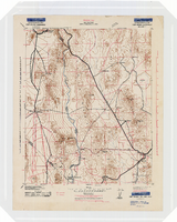
Topographic map of the Camp Mohave quadrangle in California, Nevada and Arizona, 1942
Date
1942
Description
Scale 1;250,000 ; polyconic projection (W 115°--W 114V/N 36V--N 35V) ; 1 map : col. ; 52 x 37 cm ; Relief shown by contours and spot heights. Contour interval 250 feet ; "Training map"--Center of upper margin of map ; "Base compiled from U.S. Geological Survey quadrangles. Control from U.S. Geological Survey. Revised from state highway maps for Arizona, Nevada and California" ; "Culture revisions shown in red based on reconnaissance by 67th Engr. Co. (Top.). May not be of same accuracy as base map." ; Map shows roads, trails, ponton sites, dam sites, possible air fields, possible landing fields, airports, water points, and impassable areas ; Map was originally restricted. "Classification cancelled by authority of Chief of Engineers letter of Jan. 22, 1946." ; Title at top of map: Nevada-Arizona-California : Camp Mohave quadrangle : grid zone F ; Army Map Service, U.S. Army.
Image
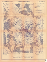
Index map showing locations of geologic sections on plate 2 and wells on plates 2 and 3, Las Vegas Valley, Nevada, 1981 (Open-file report 84-130)
Date
1981
Description
'United States Department of the Interior, Geological Survey. Open-file report 84-130, plate 4.' 'Prepared in cooperation with the Clark County Department of Comprehensive Planning.' 'Base from U.S. Geological Survey 1:100,000 , Boulder City, Ariz.-Nev., Las Vegas, Nev.-Calif., Mesquite Lake, Nev.-Calif., 1978, Lake Mead, Nev.-Ariz., 1979.' Geology from Malmberg (1965); Longwell and others (1965); Bell and Smith (1980); and J. R. Harrill, 1979.' Shows township and range lines. Scale [ca. 1:95.040. 1 in.=approx. 1.5 miles] (W 115°30´--W 115°00´/N 36°30´--N 36°00´). . Series: Open-file report (Geological Survey (U.S.))84-130. Originally published as plate 4 of Ground-water conditions in Las Vegas Valley, Clark County, Nevada. Part I. Hydrogeologic framework / by Russell W. Plume, published by the U.S. Geological Survey in 1984 as Open-file report 84-130.
Image

Surficial geologic map of Las Vegas Valley, Nevada, circa 1981
Date
1977 to 1985
Description
'United States Department of the Interior, Geological Survey. Open-file report, 84-130, plate 1.' 'Prepared in cooperation with the Clark County Department of Comprehensive Planning.' 'Base from U.S. Geological Survey 1:100,000, Boulder City, Ariz.-Nev., Las Vegas, Nev.-Calif., Mesquite Lake, Nev.-Calif., 1978, Lake Mead, Nev.-Ariz., 1979.'Geology from Malmberg (1965); Longwell and others (1965); Haynes (1967); Bingler (1977); Bell and Smith (1980); Bell (1981); Matti and Bachhuber (1982); and Matti and Morton (1982a and b); modified by R. W. Plume, 1981.' Shows township and range lines. Scale [ca. 1:102,960. 1 in.=approx. 1.625 miles] (W 115°30´--W 115°00´/N 36°30´--N 36°00´). Series: Open-file report (Geological Survey (U.S.))84-130. Originally published as plate 1 of Ground-water conditions in Las Vegas Valley, Clark County, Nevada. Part I. Hydrogeologic framework / by Russell W. Plume, published by the U.S. Geological Survey in 1984 as Open-file report 84-130.
Image
Map and basin profiles showing thickness of valley-fill deposits, Las Vegas Valley, Nevada, 1981
Date
1981
Description
At top of map: 'United States Department of the Interior. Geological Survey. Open-file report 84-130, plate 5.' 'Prepared in cooperation with the Clark County Department of Comprehensive Planning.' At bottom of map: 'Base from U.S. Geological Survey, 1:100,000, Boulder City, Ariz.-Nev., Las Vegas, Nev.-Calif., Mesquite Lake, Nev.-Calif., 1978; Lake Mead, Nev.-Ariz., 1979.' 'Geology from Malmberg (1965); Longwell and others (1965); Haynes (1967); Bell and Smith (1980); Bell (1981) and J. R. Harrill, 1976. Thickness of valley-fill deposits by R.W. Plume, 1981.' Includes three profiles. Shows township and range lines. Scale [ca. 1:95.040. 1 in.=approx. 1.5 miles] (W 115°30´--W 115°00´/N 36°30´--N 36°00´). Series: Open-file report (Geological Survey (U.S.)), 84-130. Originally published as plate 5 of Ground-water conditions in Las Vegas Valley, Clark County, Nevada. Part I. Hydrogeologic framework / by Russell W. Plume, published by the U.S. Geological Survey in 1984 as Open-file report 84-130.
Image
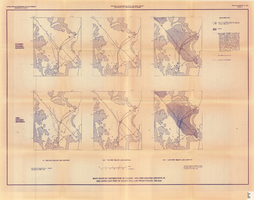
Maps showing distribution of coarse- and fine-grained deposits in the upper 1,000 feet of valley fill, Las Vegas Valley, Nevada, 1981 (Open-file report 84-130, plate 3)
Date
1981
Description
'United States Department of the Interior, Geological Survey. Open-file report 84-130, plate 3.' 'Prepared in cooperation with the Clark County Department of Comprehensive Planning.' 'Base from U.S. Geological Survey, 1:250,000, Las Vegas and Kingman, 1969.' 'Geology from Malmberg (1965); Longwell and others (1965); and J. R. Harrill, 1979. Lithology by R.W. Plume, 1981.' Contents: Coarse-grained deposits: 0-200 feet below land surface; 200-700 feet below land surface; 700-1,000 feet below land surface -- Fine-grained deposits: 0-200 feet below land surface; 200-700 feet below land surface; 700-1,000 feet below land surface. Scale [ca. 1:310,464. 1 in.=approx. 4.9 miles]. Series: Open-file report (Geological Survey (U.S.))84-130 Originally published as plate 3 of Ground-water conditions in Las Vegas Valley, Clark County, Nevada. Part I. Hydrogeologic framework / by Russell W. Plume, published by the U.S. Geological Survey in 1984 as Open-file report 84-130.
Image