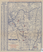
Search Results
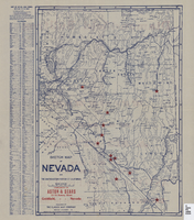
Sketch map of Nevada and the southeastern portion of California, 1906
Date
1906
Description
41 x 29 cm. Relief shown by hachures. Copyright held by George S. Clason. Includes index. "Compliments of Aston & Sears ... Goldfield, Nevada." Red stars probably indicate location of towns with either offices of or claims owned by Aston & Sears. Shows railroad routes. Ad for shares in the Diamond Bullfrog claim on verso. Original publisher: Clason Map Co..
Image
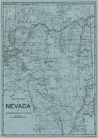
Sketch map of Nevada and the southeastern portion of California, 1906
Date
1906
Description
34 x 24 cm. Relief shown by hachures. Map may be a reprint of a map by George S. Clason, published by the Clason Map Co. in Denver, Colo., in 1906. Map is printed on blue paper. "OPHIR" and a star printed near Pueblo in Nye County. Shows railroad routes.
Image
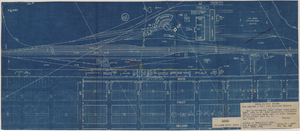
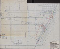
Map to accompany joint letter dated April 20th, 1931 to Mr. Gray concerning construction of proposed water main to serve lessees in Industrial Unit No. 1, Las Vegas, Nevada, April 20, 1931
Date
1931-04-20
Archival Collection
Description
'Union Pacific System. Los Angeles & Salt Lake Railraod Company.' 'Office of Industrial Engr., Los Angeles, California, April 20th, 1931. Dwg. No. 588.' Scale: 1" = 200'.
Image
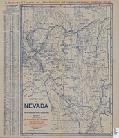
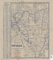
Sketch map of Nevada and the southeastern portion of California, 1906
Date
1906
Description
42 x 30 cm., fold. to 23 x 11 cm. Relief shown by hachures. Copyright: George S. Clason. "Compliments of D. Mackinzie & Company Incorporated, Mine Operators and Commission Brokers, Goldfield, Nevada." Company's locations in Goldfield and in Greenwater, California, are marked with red circles on the map. Includes index. Shows railroad routes. Original publisher: Clason Map Co..
Image
Sketch map of Nevada and the southeastern portion of California, 1906
Date
1906
Description
42 x 29 cm. Relief shown by hachures. Copyright held by George S. Clason. "Compliments of the Patrick Investment Co. ... Denver, Colorado." Includes index. Shows railroad routes. "We have offices, representatives and properties in every camp marked in red on this map." Original publisher: Clason Map Co..
Image
Map of water pipelines owned by or to be sold to the Las Vegas Valley Water District, March 1, 1953
Date
1953-03-01
Archival Collection
Description
Map shows portions of pipelines to be sold to the Las Vegas Valley Water District, pipelines connected to those to be sold to the District that will be retained by the railroad companies, and privately-owned pipelines connecting to those to be sold to the District. 'Exhibit D.' 'March 1, 1953.' 'I-128.' Las Vegas Land and Water Company?
Image
Map of Las Vegas Valley Water District, December 29, 1952
Date
1952-12-29
Archival Collection
Description
'Exhibit A.' 'Dec. 29, 1952.' 'I-128.' Scale [ca. 1:3,600]. 1 in.=300 feet. Shows water pipelines, other parts of the water system, and power lines to be removed or relocated when land is sold to the Las Vegas Valley Water District. Shows land to be sold and lists power requirements for water system. Includes township and range lines. Library's copy includes hand-written notations and calculations. Los Angeles & Salt Lake Railroad Company, Office of Vice President?
Image
Sketch map of Nevada and the southeastern portion of California, 1906
Date
1906
Description
1907 written in red pencil at top of map. 41 x 29 cm. Relief shown by hachures. Copyright held by George S. Clason. Includes index. "Compliments of A.E. Holt, real estate and mines, Bullfrog Mining Dist., Rhyolite, Nevada." Red star indicates location of A.E. Holt company. Shows railroad routes. Library's copy has "1907" printed with brown crayon in upper margin and has four sets of two holes punched in a vertical line along the right third of the map. Original publisher: Clason Map Co..
Image
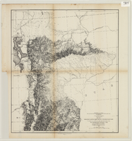
From the valley of Green River to the Great Salt Lake
Date
1855
Description
'From explorations and surveys made under the direction of the Hon. Jefferson Davis, Secretary of War, by Capt. E.G. Beckwith, 3rd Artillery, E.G. Egloffstein, topographer for the route. 1855.' ''Selmar Siebert's Engraving & Printing Establishment, Washington, D.C.' Published by the War Dept. Scale 1:760,320. 12 miles to 1 in. Relief shown by hachures and spot heights.
Image
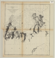
From the Great Salt Lake to the Humboldt Mountains
Date
1855
Description
'From explorations and surveys made under the direction of the Hon. Jefferson Davis, Secretary of War, by Capt. E.G. Beckwith, 3rd Artillery, E.G. Egloffstein, topographer for the route. 1855.' ''Selmar Siebert's Engraving & Printing Establishment, Washington, D.C.' Published by the War Dept. Scale 1:760,320. 12 miles to 1 in. Relief shown by hachures and spot heights.
Image