Search Results
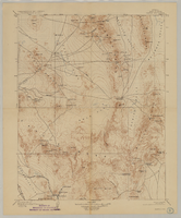
Map of Kawich Quadrangle, Nye County, Nevada, June 1908
Date
1908-06
Description
At upper left corner: 'Department of the Interior, U.S. Geological Survey.' 'E. M. Douglas, geographer; R. G. Chapman, in charge of section; triangulation and topography by R. H. Chapman and B. D. Stewart. Surveyed in 1905.' 'Engraved April 1906 by U.S.G.S.' 'Edition of June 1908, repritned 1929.' 'Polyconic projection. North American datum.' Guide to Topographic Maps of the United States series on map verso. UNLV Special Collections Southern Nevada Mining Map Collection
Text

Map showing detailed topography of the country traversed by the reconnaissance expedition through southern & southeastern Nevada, 1869 (reproduction)
Date
1869
Description
At top of map: 'Reconnaissance Maps, Department of California.' 'In charge of, Lieut. Geo. M. Wheeler, U.S. Engineers; assisted by Lieut. D.W. Lockwood, Corps of Engineers,U.S.A., 1969.' 'P.W. Hamel, chief topographer and draugthsman.' 'Traced 11-13-67.' 'BGS'; the G is enclosed in an arrowhead shape. 'Officially compiled and published at the Engineer Office, Head Quarters Department of California in 1869 and 70 by order of Brigadier General E.O.C. Ord. Comm'dg. [signed] Geo. M. Wheeler, Lieutenant of Engineers In Charge, Head Quarters Dept. of Cal. Oct. 26th, 1870.' Includes information from railroad maps, the United States Geological Survey of the 40th parallel and from Lieutenant Ives' explorations along the Colorado. Map includes camps, astronomical stations, good and bad wagon roads, trails, springs, settlements, mining districts, state and county boundaries and the watershed between the Humboldt and Colorado Basin. Shows most of eastern half of Nevada. Relief shown by hachures and spot heights. Scale indeterminable. (W 117°00´--W 113°00´/N 41°45´--N 35°45´). Series: Reconnaissance maps. Military map / Department of Californiano. 1. Reproduction. Map is printed in purple. Scale of original map: [1:760,320]. 1 in. to approx. 12 miles. Includes dots hand-colored with red pencil marking Indian rancherias.
Image
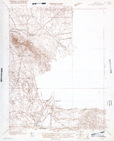
Map of Ely Range Quadrangle, Lincoln County, Nevada, 1921
Date
1921
Description
'Edition of 1921.' 'W. H. Herron, Acting Chief Geographer; Geo. R. Davis, Geographer In Charge; Topography by H. H. Hodgeson, N. E. Ballmer, and W. B. Upton, Jr.; Control by H. H. Hodgeson, Roscoe Reeves, and D. S. Birkett. Surveyed in 1916.' At top of map: ' Topography, State of Nevada.' At upper left corner: ' Department of the Interior, Albert B. Fall, Secretary; U.S. Geological Survey, George Otis Smith, Director.' Southern Nevada Mining Map Collection. 15 minute series (topographic) Nevada.
Image

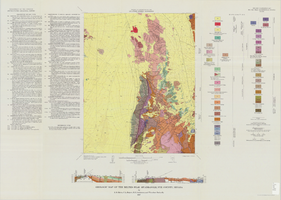
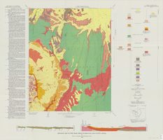
Geologic map of the Lathrop Wells quadrangle, Nye County, Nevada, 1970
Date
1970
Description
58 x 47 cm., on sheet 74 x 84 cm., folded in envelope 30 x 24 cm. Relief shown by contours and spot heights. "Bedrock geology mapped by B.C. Burchfiel, 1961, and by E.J. McKay and K.A. Sargent, 1965-66. Surficial geology mapped by A.T. Fernald, 1968." Includes cross sections, description of map units, and location map. "Prepared in cooperation with the U. S. Atomic Commission." Original publisher: Interior, Geological Survey, Series: Geologic quadrangle map GQ, Scale: 1:24 000.
Image

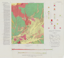
Geologic map of the Topopah Spring quadrangle, Nye County, Nevada, 1970
Date
1970
Description
58 x 46 cm., on sheet 84 x 88 cm., folded in envelope 30 x 24 cm. Relief shown by contours and spot heights. "Geology mapped in 1962-63." Includes description of map units, colored columnar section, 3 colored cross sections, and quadrangle location map. "Prepared in cooperation with the U. S. Atomic Commission." Original publisher: Interior, Geological Survey, Series: Geologic quadrangle map GQ, Scale: 1:24 000.
Image

Geologic map of the Tippipah Spring quadrangle, Nye County, Nevada, 1963
Date
1963
Description
58 x 46 cm., on sheet 84 x 81 cm., folded in envelope 30 x 24 cm. Relief shown by contours and spot heights. "Geology by P.P. Orkild, 1959-60, paleotopography by D.L. Healey and C.H. Miller, 1959-60." Series statement from envelope. Includes description of map units, 2 col. cross sections, and quadrangle location map. "Prepared in cooperation with the U. S. Atomic Commission." Original publisher: Interior, Geological Survey, Series: Geologic quadrangle map GQ, Scale: 1:24 000.
Image

Geologic map of the Ammonia Tanks quadrangle, Nye County, Nevada, 1967
Date
1967
Description
58 x 46 cm., on sheet 84 x 100 cm., folded in envelope 30 x 24 cm. Relief shown by contours and spot heights. "Base by U.S. Geological Survey, 1961." "Geology mapped in 1961-65." "Contour interval 20 feet." Includes 3 col. cross sections, 1 index map, text with bibliography, and quadrangle location map. "Prepared in cooperation with the U. S. Atomic Commission." Original publisher: Interior, Geological Survey, Series: Geologic quadrangle map GQ, Scale: 1:24 000.
Image
Geologic map of the Belted Peak quadrangle, Nye County, Nevada, 1967
Date
1967
Description
45 x 36 cm., on sheet 64 x 89 cm., fold. in envelope 30 x 24 cm. Relief shown by contours and spot heights. "Contour interval 40 feet." "Prepared in cooperation with the U.S. Atomic Energy Commission." "Geology mapped in 1962-63." Includes text, 2 col. cross sections, and quadrangle location map. Original publisher: U.S. Geological Survey, Series: Geologic quadrangle map GQ, Scale: 1:62 500.
Image
Geologic map of the Thirsty Canyon quadrangle, Nye County, Nevada, 1966
Date
1966
Description
57 x 46 cm., on sheet 83 x 91 cm., folded in envelope 30 x 24 cm. Relief shown by contours and spot heights. "Geology mapped in 1963." Includes 2 colored cross sections, index map, text, and quadrangle location map. "Prepared in cooperation with the U. S. Atomic Commission." Original publisher: Interior, Geological Survey, Series: Geologic quadrangle map GQ, Scale: 1:24 000.
Image
Geologic map of the Trail Ridge quadrangle, Nye County, Nevada, 1968
Date
1968
Description
58 x 46 cm., on sheet 79 x 91 cm., folded in envelope 30 x 24 cm. Relief shown by contours and spot heights. "Prepared in cooperation with the U.S. Atomic Energy Commission." "Base by U.S. Geological Survey, 1962." "Geology mapped in 1963." "Contour interval 20 feet." Includes text, 2 col. cross sections, quadrangle location map, and 1 index map. Original publisher: Interior, Geological Survey, Series: Geologic quadrangle map GQ, Scale: 1:24 000.
Image