Search Results
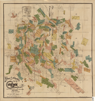
Map of the Goldfield Mining District, Nye and Esmeralda Counties, Nevada, 1905
Date
1905
Description
Copyright 1905 by Elmer J. Chute, E.M. Goldfield, Nev. In lower right corner: "Designed and drawn by R.W. Griswold." Includes inset location map; Includes township and range grid. Scale [ca. 1:20, 400. 1 in.=aprrox. 1,700 feet]
Image
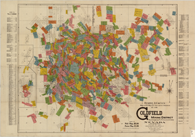
Map of U.S. patent and location surveys in the Goldfield Mining District, Esmeralda and Nye Counties, Nevada, 1907
Date
1907
Description
'Elmer J. Chute, E.M. and Olmstead & Rich. U.S. Deputy Mineral Surveyors, 1907. Copyright 1907 by Elmer J. Chute, E.M., Goldfield, Nev.' Includes index Includes township and range grid. Scale [ca. 1:22,800. 1 in. to approx. 1900 feet]
Text
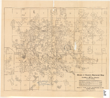
Map of the Goldfield Mining District, Goldfield, Nevada, 1907
Date
1907
Description
'Elmer J. Chute, E.M. and Olmstead and Rich, Goldfield, Nevada. Copyright 1907, by Elmer J. Chute, Goldfield, Nev.' Includes information on and prices for wall and pocket map with this title. Includes inset map. Includes township and range grid. Library's copy has Rochester GF. claim circled in blue ink , has a piece missing to the right of that claim, and has "Mohawk ledge, a lease by Davis & Shoemaker" written in blue ink at the center bottom of the map with a line in blue ink drawn to the Frances Mohawk claim.
Image

Map of Argentite Red Mountain Mining District, Esmeralda County, Nevada, circa 1908-1913
Date
1908 to 1913
Description
'Compiled by C. A. Liddell, U.S. Mineral Surveyor, Tonopah, Nevada, from surveys by Sherwin, Giles and Liddell.' Published between 1908-1913? Scale [ca. 1:7,200]. 1 in. equals 600 feet. Map printed on linen.
Image
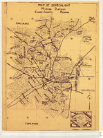
Map of Searchlight mining district, Clark County, Nevada, circa 1905
Date
1901 to 1909
Description
At bottom right of map: 'C.D. Baker, A.R. Thompson.' Title in lower right corner: 'Map of Searchlight mining district: mineral patents, water rights.' Logo of Nevada Engineering Construction Service, Inc., Las Vegas, Nev. in lower right corner. Blueline print. Shows mineral patents and water rights. Nevada Engineering & Construction Service, Inc.
Image
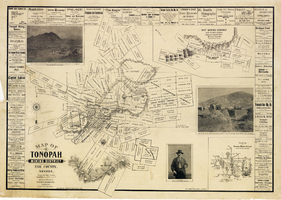
Map of Tonopah Mining District, Nye County, Nevada, 1902
Date
1902
Description
'Compiled and published by Booker & Bradford, engineers, Tonopah, Nevada.' 'Copyrighted by Booker & Bradford 1902.' 'Lith. Britton & Rey, S.F., Cal.' Relief shown by hachures. Includes insets of Ray Mining District, Nye County, Nevada, and Vicinity map of Tonopah Mining District, Nye County, Nevada. Includes advertisements and photographs of Tonopah ore, town of Tonopah, and of J.L. Butler, discoverer of the Mizpah Lode. Scale [ca. 1:7,200]. 1 inch to 600 feet. Mounted on linen.
Text
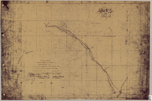
Map showing right of way of toll road constructed by Nevada Rapid Transit Co. in Lincoln County, State of Nevada
Date
1905-08-10
Description
Shows right of way of what now is Interstate 95 through what is now Clark County, Nevada. 'Aug. 10, 1905.' 'Adopted as toll road of Nevada Rapid Transit Company at meeting of Board of Directors of said company Aug. 25th, 1905. Attest W.H. Comstock, secretary, J. Ross Clark, president.' 'Book I, page 3'--Lower right corner. '... No. ... Recorded at ... [signed] J. Ross Clark ... September 1st A.D. 1905 at 40 ... past 8 A.M. to Book of Platts, Pages ... Lincoln Co. Nev. Record ... [signed] Henry Lee ...'--upper right portion of map. Seal of the Nevada Rapid Transit Company in lower left portion of map. Scale [ca. 126,720]. 1 in.=2 miles 1 map. Blueline print.
Image
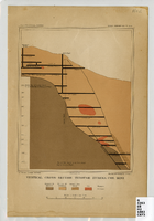
Vertical cross-section of Eureka Consolidated Mine, 1883
Date
1883
Description
'G. F. Becker, geologist-in-charge. Julius Bien & Co. lith. Mapping and geology by J. S. Curtis.' 'U.S. Geological Survey. Annual report 1883, pl. XXXIII.' Published by U.S. Geological Survey. Scale [ca. 1:2,400] 1 in.=200 feet. Library's copy has "Nev." printed in pencil in upper right corner.
Image
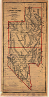
Map of Lincoln and Clark Counties, Nevada, 1908
Date
1908
Description
'Map of Lincoln County, Nevada. Compiled by H.E. Freudenthal from official surveys. Copyright, 1908, by H.E. Freudenthal.' Relief shown by hachures and spot heights. Shows range and township grid. Shows towns, railroads, proposed railroads, wagon roads and springs. Scale [ca. 1:380,160]. 1 in. to approx. 6 miles (W 116°--W 114°/N 39°--N 35°).
Image
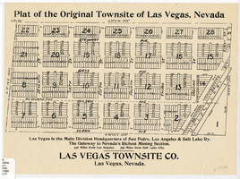
Plat of the original townsite of Las Vegas, Nevada, circa 1905
Date
1901 to 1910
Description
'Las Vegas is the main division headquarters of San Pedro, Los Angeles & Salt Lake Ry. The gateway to Nevada's richest mining section. 336 miles from Los Angeles. 444 miles from Salt Lake City.' Second copy available in the J.T. McWilliams manuscript collection.
Image