Search Results
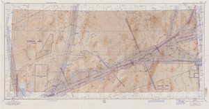
Elko sectional aeronautical chart, September 29, 1959
Date
1959-09-29
Description
52 x 110 cm. Relief shown by gradient tints, contours, and spot heights. Contour interval 1,000 feet. "Aeronautical data on this chart includes data received through Sept. 29, 1959." "Consult appropriate NOTAMS and Radio Facility Charts for supplemental data and current information." "Next edition is scheduled in approximately one year." "Base: Edition of May 1956. Revised Sept. 1958." "Lambert Conformal Conic Projection." "Standard Parallels 33° and 45°." "Elko compiled and printed at Washington, D. C. by the U. S. Coast and Geodetic Survey under authority of the Secretary of Commerce." "Principal sources: U. S. Geological Survey, U. S. Army Corps of Engineers, U. S. Air Force, U. S. Dept. of Agriculture, Civil Aeronautics Administration, and the U. S. Coast and Geodetic Survey." "Base: Edition of May 1956, revised Sept. 1958." "Detailed airport data and other useful information are printed on the back of this chart." Includes text, gradient tints scale and index to adjoining sheets. On verso: text, index map of sectional charts, inset maps of U.S. air defense identification zones and defense area, visual emergency signals, and charts. Original publisher: U.S. Coast and Geodetic Survey, Scale: 1:500,000.
Image

Map showing detailed topography of the country traversed by the reconnaissance expedition through southern & southeastern Nevada, 1869
Date
1869
Description
At top of map: 'Reconnaissance Maps, Department of California.' In lower right corner: 'Photolith. by the N.Y. Lithg. Engrg. & Prtg. Co.' 'In charge of, Lieut. Geo. M. Wheeler, U.S. Engineers; assisted by Lieut. D.W. Lockwood, Corps of Engineers,U.S.A., 1969.' 'P.W. Hamel, chief topographer and draugthsman.' 'Officially compiled and published at the Engineer Office, Head Quarters Department of California in 1869 and 70 by order of Brigadier General E.O.C. Ord. Comm'dg. [signed] Geo. M. Wheeler, Lieutenant of Engineers In Charge, Head Quarters Dept. of Cal. Oct. 26th, 1870.' Includes information from railroad maps, the United States Geological Survey of the 40th parallel and from Lieutenant Ives' explorations along the Colorado. Map includes camps, astronomical stations, good and bad wagon roads, trails, springs, settlements, mining districts, state and county boundaries and the watershed between the Humboldt and Colorado Basin. Shows most of eastern half of Nevada. Relief shown by hachures and spot heights. Scale: [1:760,320]. 1 in. to approx. 12 miles. (W 117°00´--W 113°00´/N 41°45´--N 35°45´). Series: Reconnaissance maps. Military map / Department of Californiano. 1.miles. Library's copy has counties hand-outlined in colored markers.
Image

Map showing detailed topography of the country traversed by the reconnaissance expedition through southern & southeastern Nevada, 1869 (reproduction)
Date
1869
Description
At top of map: 'Reconnaissance Maps, Department of California.' 'In charge of, Lieut. Geo. M. Wheeler, U.S. Engineers; assisted by Lieut. D.W. Lockwood, Corps of Engineers,U.S.A., 1969.' 'P.W. Hamel, chief topographer and draugthsman.' 'Traced 11-13-67.' 'BGS'; the G is enclosed in an arrowhead shape. 'Officially compiled and published at the Engineer Office, Head Quarters Department of California in 1869 and 70 by order of Brigadier General E.O.C. Ord. Comm'dg. [signed] Geo. M. Wheeler, Lieutenant of Engineers In Charge, Head Quarters Dept. of Cal. Oct. 26th, 1870.' Includes information from railroad maps, the United States Geological Survey of the 40th parallel and from Lieutenant Ives' explorations along the Colorado. Map includes camps, astronomical stations, good and bad wagon roads, trails, springs, settlements, mining districts, state and county boundaries and the watershed between the Humboldt and Colorado Basin. Shows most of eastern half of Nevada. Relief shown by hachures and spot heights. Scale indeterminable. (W 117°00´--W 113°00´/N 41°45´--N 35°45´). Series: Reconnaissance maps. Military map / Department of Californiano. 1. Reproduction. Map is printed in purple. Scale of original map: [1:760,320]. 1 in. to approx. 12 miles. Includes dots hand-colored with red pencil marking Indian rancherias.
Image