Search Results

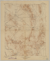
Map of Las Vegas Valley, Clark County, Nevada, October 1, 1940
Date
1940-10-01
Archival Collection
Description
'Compiled by C.D. Baker, Civil Engineer, State Water Right Surveyor, Mineral Surveyor, Gen. Land Office, Las Vegas, Clark County, Nevada. Oct. 1, 1940.' Yellow lines show boundary of the proposed water district; green lines show boundary of the city of Las Vegas; red line shows the Union Pacific Railroad route.
Image
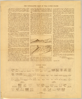
Map of the Bullfrog Mining District, Nye County, Nevada, circa 1905
Date
1901 to 1909
Description
At top of map: 'Compliments of the Forward Mining Development Co.' On left and right margins: 'The Patrick Investment Company, Fiscal Agents.' At bottom of map: '19 Toltec Block, Denver, Colorado.' 'The Williamson-Haffner Co., Denver.' Relief shown by hachures. Properties owned by Patrick Investment Company are marked in red. Shows railroads, roads, and pipelines. Scale [ca. 1:39,000. 1 in. to approx. 3,250 feet].
Image
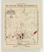
Map of Tonopah Mining District, Nye County, Nevada, circa 1903
Date
1899 to 1907
Description
Map showing mining claims in Tonopah Mining District, including areas owned by Tonopah Amalgamated Mining Co.; David Keith's Company of Salt Lake, Utah; Mispah Extension Company; Tonopah Mining Company of Nevada; Gold Hill Mining Co. Relief shown by hachures. Scale [ca. 1:7,200]. 1 in. equals 600 feet. Library's copy has some mines cross-hatched in pencil.
Image
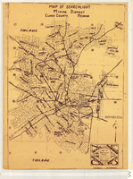
Map of Searchlight mining district, Clark County, Nevada, circa 1905
Date
1901 to 1909
Description
At bottom right of map: 'C.D. Baker, A.R. Thompson.' Title in lower right corner: 'Map of Searchlight mining district: mineral patents, water rights.' Logo of Nevada Engineering Construction Service, Inc., Las Vegas, Nev. in lower right corner. Blueline print. Shows mineral patents and water rights. Nevada Engineering & Construction Service, Inc.
Image

Map of the Las Vegas ground-water basin, Clark, Nye, and Lincoln Counties, Nevada, 1965
Date
1965
Description
At top of map: 'United States Department of the Interior, Geological Survey. Water-supply paper 1780, plate 1.' At bottom of map: 'Base from Army Map Service sheets NJ 11-9, NJ 11-12, and NI 11-3 (1947).' 'Boundary between bedrock and alluvium in Clark County, Nev., compiled by Ben Boyer, E. H. Pampeyan and C. R. Longwell. In Lincoln and Nye Counties, contact determined from aerial photographs.' 'Interior--Geological Survey, Washington, D.C.--1965--W63358.' Includes township and range lines.Relief shown by contours. Thematic map. Scale 1:250,000 (W 116°--W 114°45´/N 37°00´--N 35°30´). Series: Water-supply paper (Washington, D.C.), 1780. Originally published as plate 1 of Available water supply of the Las Vegas ground-water basin, Nevada, by Glenn T. Malmberg, published by the Geological Survey in 1965 as its Water-supply paper 1780.
Image
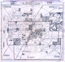
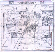
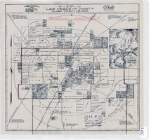
Map of the city of Las Vegas and vicinity, Clark County, Nevada, 1929
Date
1929
Description
'Copyright 1929, C.D. Baker, civil engineer. Drawn by R.C. Kenmir.' Includes inset sketch showing general location of Las Vegas, Nev. Relief shown pictorially on inset map. Scale [ca. 1:39,600. 1 in. to 0.625 mile]. Cadastral map. Library's copy 1 has hand-drawn brown line and red circles. Library's copy 2 has "Proposed annexation" printed in capital letters in red pencil near the top, has a brown line drawn around the area.
Image