Search Results
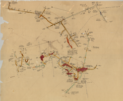
Map of the 600 foot, or third, level of the Clermont Mine, Goldfield, Nevada, circa 1902-1908
Date
1902 to 1908
Description
Hand-drawn, hand-colored and annotated map showing the 600 foot, or third, level of the Clermont Mine. Handwritten at top of map: 'Clermont, 3rd level.'
Image
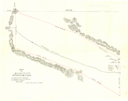
Map of Moapa River Reservation, located and surveyed by C. A. Bateman & A. J. Barnes, U.S. Indian agents, Nevada, 1875
Date
1875
Description
Scale 600 ft. to 1 inch. Relief shown by hachures. Shows buildings. Shows township and range grid. "Rec with Indian office letter June 10 1875. Copies sent to Sup. Gen. and R&R at Pioche Nevada August 9 1875" handwritten in blue ink on verso.
Image
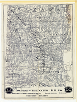
Map showing Tonopah & Tidewater Railroad Company line from Ludlow, California to Goldfield, Nevada, circa 1907
Date
1905 to 1909
Description
Scale not given. Relief shown by hachures and spot heights. Shows township and range grid. Shows mines, camps and ranches. Tonopah & Tidewater Railroad Company. Library's copy mounted on linen.
Image

Hydrogeologic map of Nevada Test Site and vicinity, southern Nevada, 1965
Date
1965
Description
At top of map: ' United States Department of the Interior, Geological Survey. Professional paper 712-C, plate 1. Prepared on behald of the U.S. Atomic Energy Commission.' At bottom of map: 'Base from U.S. Geological Survey, Caliente, Death Valley, Goldfield and Las Vegas, 1954. 100,00-foot grid based on Nevada coordinate system, central zone.' 'Hydrogeology by I. J. Winograd, 1965; geology by William Thordarson.' Relief shown by contours and spot heights. Shows township and range lines. Includes diagram of downward and upward cross-flow of water. Includes bibliographical references and index. Contour interval 200 feet. Scale 1:250,000 (W 117°--W 115°/N 38°--N 36°). Series: Professional paper (Geological Survey (U.S.), 712-C. Issued as plate 1 from Hydrogeologic and hydrochemical framework, south-central Great Basin, Nevada-California with special reference to the Nevada Test Site. Prepared on behalf of the U.S. Atomic Energy Commission by Isaac J. Winograd and William Thordarson. Published 1975 by U.S. Govt. Print. Off. in Washington.
Image