Search the Special Collections and Archives Portal
Search Results
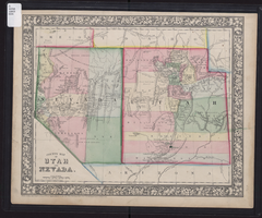
County map of Utah and Nevada, 1865
Date
1865
Description
'Entered according to Act of Congress in the year 1865 by S. Augustus Mitchell, Jr. in the Clerk's office of the District Court of the U.S. for the Eastern District of Pennsylvania . Drawn and engraved by W.H. Gamble, Philadelphia.' Shows roads, overland telegraph route, and other features. Relief shown by hachures and spot heights. Prime meridians: Greenwich and Washington. Scale [ca. 1:2,787,840] (W 120°--W 109°/N 43°--N 36° 59?).
Image
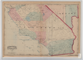
Map of southern California and southern Nevada, 1872
Date
1872
Description
'Entered according to Act of Congress in the year 1872 by Asher & Adams in the office of the Librarian of Congress at Washington.' Scale [ca. 1:1,267,300]. 1 in. to 20 miles (W 124°--W 114°/N 42°--N 32°). Shows natural features, populated places, county boundaries and railroads Prime meridians: Greenwich and Washington. In top margins: 95-96 (south portion). Shows range and township grid. Hand colored. Asher & Adams.
Image
Pagination
Refine my results
Content Type
Creator or Contributor
Subject
Archival Collection
Digital Project
Resource Type
Year
Material Type
Place
Language
Records Classification

