
Search the Special Collections and Archives Portal

Search Results

Display    Results Per Page
Displaying results 156311 - 156320 of 156493

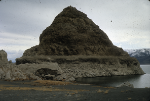
Slide of a tufa deposit in Pyramid Lake, Nevada, circa 1970s

Date

1970 to 1979

Description

The pyramid-shaped island tufa that lies along the east shore of the lake and is the reason the lake was named Pyramid Lake. Pyramid Lake is the geographic sink of the Truckee River Basin, 40 mi (64 km) northeast of Reno. Pyramid Lake is fed by the Truckee River, which is mostly the outflow from Lake Tahoe. The Truckee River enters Pyramid Lake at its southern end. Pyramid Lake has no outlet, with water leaving only by evaporation, or sub-surface seepage (an endorheic lake). The lake has about 10% of the area of the Great Salt Lake, but it has about 25% more volume. The salinity is approximately 1/6 that of sea water. Although clear Lake Tahoe forms the headwaters that drain to Pyramid Lake, the Truckee River delivers more turbid waters to Pyramid Lake after traversing the steep Sierra terrain and collecting moderately high silt-loaded surface runoff. Pyramid Lake is the site of some of the Earth's most spectacular tufa deposits. Tufa is a rock composed of calcium carbonate (CaCO3) that forms at the mouth of a spring, from lake water, or from a mixture of spring and lake water. The explorer John C. Fremont (1845) wrote about the tufas during his 1843-44 expedition and named the lake after the pyramidal-shaped island that lies along the east shore of the lake. The Paiute name for the island is Wono, meaning cone-shaped basket. The Paiute name for the lake is Cui-Ui Panunadu, meaning fish in standing water.

Image

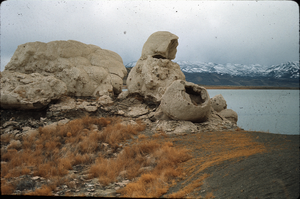
Slide of the rock formation known as The Squaw and Her Basket, Pyramid Lake, Nevada, circa 1970s

Date

1970 to 1979

Description

The rock formation known as The Squaw and Her Basket, Pyramid Lake, Nevada. Pyramid Lake is the geographic sink of the Truckee River Basin, 40 mi (64 km) northeast of Reno. Pyramid Lake is fed by the Truckee River, which is mostly the outflow from Lake Tahoe. The Truckee River enters Pyramid Lake at its southern end. Pyramid Lake has no outlet, with water leaving only by evaporation, or sub-surface seepage (an endorheic lake). The lake has about 10% of the area of the Great Salt Lake, but it has about 25% more volume. The salinity is approximately 1/6 that of sea water. Although clear Lake Tahoe forms the headwaters that drain to Pyramid Lake, the Truckee River delivers more turbid waters to Pyramid Lake after traversing the steep Sierra terrain and collecting moderately high silt-loaded surface runoff. Pyramid Lake is the site of some of the Earth's most spectacular tufa deposits. Tufa is a rock composed of calcium carbonate (CaCO3) that forms at the mouth of a spring, from lake water, or from a mixture of spring and lake water. The explorer John C. Fremont (1845) wrote about the tufas during his 1843-44 expedition and named the lake after the pyramidal-shaped island that lies along the east shore of the lake. The Paiute name for the island is Wono, meaning cone-shaped basket. The Paiute name for the lake is Cui-Ui Panunadu, meaning fish in standing water.

Image

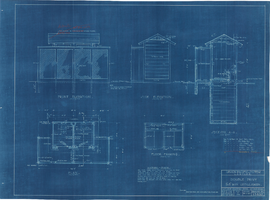
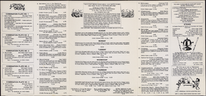
Los Angeles & Salt Lake Railroad Company double privy: architectural drawing

Date

1926-06-14
1927-05-05

Archival Collection

Description

From Union Pacific Railroad Collection (MS-00397). The scales are noted in the drawing. The bottom of the drawing says, "Material-Finish: All Finish Lumber Unless Otherwise Noted Shall Be [Opsas?] Wood Work Of Vault Shall Be O.P Rough. Exterior Of Privy Including Both Sides Of Door And Door Jamb: Also Wood Lattice Screen On All Sides Shall Be Painted With 3 Coats C.S. Lead & Oil Paint As Directed. Doors Shall Be Hung On 3 1/2" x 3 1/2" Botts. Doors Shall Be Provided With Rim Latch Knob Lock And Iron Barrel Bolt. Revisions: Added Vent Stacks, Seat Cover, Double Floor & Floor Shoe". 

The bottom corner of the drawing states, "Union Pacific System L.A. & S.L.R.R. Double Privy 5'x8' With Lattice Screen. Ass't Chief Engineer's Office. Los Angeles, Calif. Drawn By E.C.B. Traced By E.C.B. Checked By F.W.G. Date June 14, 1926. Scale As Noted. Revised May 5. 1927. Drawing No. 15637".

Also written on the drawing: "Two to be built at East Yard, Calif. One ' ' Big Springs, Nev. ' ' Las Vegas, Nev. ' ' Borden, Utah. ' ' Elgin, Nev. 1927. ' ' Dry Lake, Nev. 1927. ' '  Wann ' ' 1928 [crossed out]."

Image

By-laws of the Nathan Adelson Hospice, November 30, 1978

Date

1978-11-30

Archival Collection

Description

The by-laws of the Nathan Adelson Hospice establish the purpose and organization of the program, founded in 1978 in Las Vegas.

Text

Homer Rissman Architectural Records

Identifier

MS-00452

Abstract

The collection is comprised of architectural records (1947-2001) of American architect, Homer Rissman and the architectural firm, Rissman and Rissman Associates Ltd, a partnership of Homer Rissman and his brother Marshall. The collection includes 825 items from over 40 major projects and over 110 minor projects. The Rissmans' work represented in the collection focused on Las Vegas, Reno, and Lake Tahoe, Nevada, Los Angeles, Southern California, and Arizona, with Homer's early career design work in Chicago, Illinois. The materials feature hand-drawn architectural drawings, ranging from pencil and ink on tracing paper preliminary sketches to ink on Mylar (TM) construction documents, and a number of artist’s renderings, used for presentations and promotional materials. The drawings also contain work from a number of consultants, engineers, and other architects who collaborated on the development of the various projects. The collection includes architectural drawings for: hotels, casinos, integrated casino resorts, office towers, multi-family residential developments, and custom single-family homes.

Archival Collection