Search Results
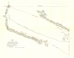
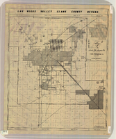
Map of Moapa River Reservation, located and surveyed by C. A. Bateman & A. J. Barnes, U.S. Indian agents, Nevada, 1875
Date
1875
Description
Scale 600 ft. to 1 inch. Relief shown by hachures. Shows buildings. Shows township and range grid. "Rec with Indian office letter June 10 1875. Copies sent to Sup. Gen. and R&R at Pioche Nevada August 9 1875" handwritten in blue ink on verso.
Image
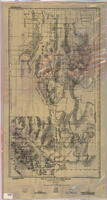
Map of a part of southern Nevada showing ground-water conditions, 1914
Date
1914
Description
At bottom of map: 'Base compiled from plane-table sheets, topographic maps of U.S. Geological Survey, railroad alignments, and General Land Office data.' Relief shown by hachures and spot heights. Shows township and range grid. Covers from southeast corner of White Pine County to Sloan and from Nye County border to Arizona-Utah border. Shows flowing wells, nonflowing wells, springs, flowing-well areas, dry holes and shore lines of ancient lakes. Scale 1:500,000 (W116°--W 114°/N 45°--N 36°). Series: Water-supply paper (Washington, D.C.), 365. Map is plate 1 from the U.S. Geological Survey water-supply paper 365.
Image
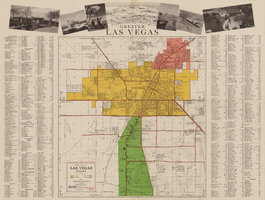
General map of Las Vegas, Nevada, circa 1957
Date
1955 to 1959
Description
'Compiled and issued by the Campbell Realty Company.' At top pf map: ' Greater Las Vegas.' Shows names of housing tracts and locations of hotels and motels on the Las Vegas Strip. Includes indexes and photographs of local recreation and attractions. Originally published by Campbell Realtydistributed by Las Vegas Nevada Chamber of Commerce . Scale (ca. 1:39,000. 1 in. to approx. 3,250 ft.].
Text
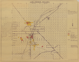
Map of Las Vegas Valley, 1968
Date
1968
Description
'This map compiled by General Drafting Service to show purchases in the Las Vegas area by Howard Hughes and others reported to be affiliated with him.' Shows land owned by Howard Hughes and land owned by Hughes Tool Company. Includes locations of casinos on Las Vegas Strip. Original publisher: General Drafting Service. Scale [ca. 1:48,000]. 1 in. to 4,000 feet. Hand-colored.
Image
Map of Las Vegas Valley, Clark County, Nevada, circa 1950-1956
Date
1950 to 1956
Description
'Nevada Title Insurance Co. Compiled by Tyson Engineering Co. ... Las Vegas, Nevada. Drawn by A.A. Elliott, Jr.' Shows sewer, water, gas and power lines, water treatment facilities, steam plants, boundaries of the Las Vegas Valley Water District and the Clark County Sanitation District boundaries. Scale [ca. 1:63,360. 1 in. to approx. 1 mile].
Image
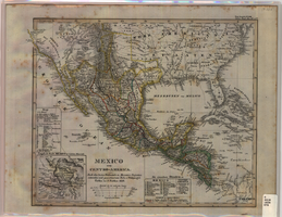
Map of Mexico and Central America, 1828
Date
1828
Description
Includes southwestern and southeastern United States and parts of the Caribbean islands. 'Nach den besten Hülfsmitteln in Mercators Projection entworfen und gezeichnet vom Pr.L. v. Stülpnagel. Gotha, bei J. Perthes, 1828.' Scale ca. 1:14,000,000 ; Mercator projection. Relief shown by hachures. Prime meridian: Washington, D.C. Inset: 'Umgeb d. Stadt Mexico in 4 fachen Maasstab [sic].' Hand colored. In upper right corner: 'Neue Ausgabe No. LVIII. Stielers Hand-Atlas (no.47b).' Includes index. Includes southern United States and part of West Indies. J. Perthes
Image
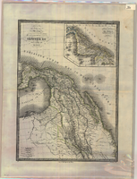
Map of Mexico and Central America, 1842
Date
1842
Description
'Dresseé par M. Lapie, Colonel d'Etat Major. Et M. Lapie fils Capitaine au même Corp. Paris, 1842. Chez P.C. Lehuby Libre. Rue de Seine No. 53.' Scale [ca. 1:9,504,000. 1 in. to approx. 15 miles]. Relief shown by hachures. Prime meridian: Paris. Hand colored. 'Atlas universel 44e'--Upper margin. Probably from P. Lapie and A.É. Lapie's Atlas universel de géographie ancienne et moderne. Inset map: Carte du Guatemala ou provinces-unies de L'Amérique Centrale. P.C. Lehuby
Image
Regional map showing main air, highway, bus and railroad transportation, October 30, 1945
Date
1945-10-30
Description
50 x 70 cm. Blue-line print. Shows Arizona, western New Mexico, southwestern Utah, southern Nevada, and southern California. Also shows irrigation projects constructed and under construction. "Oct. 30, 1945. Rev. 2-14-46." "Drawn and traced by F. R. M." Original publishser: Bureau of Reclamation, Region III.
Image

Map of Las Vegas Valley artesian basin, circa 1940
Date
1938 to 1942
Description
Scale [ca. 1:72,000. 1 in.=approx. 6,000 feet] (W 115°10´--W 115°/N 36°20´--N 36´). Shows wells, springs, boundary between valley fill and bedrock, and ground water district boundaries for Las Vegas Metropolitan Area and North Las Vegas. "Figure 1." Nevada. State Engineer
Image
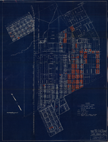
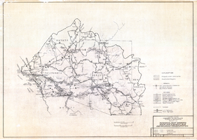
Map showing general plan for the district boundary of Lateral Sanitary Sewer District No. 1, Las Vegas, Nevada, circa 1928
Date
1925 to 1932
Description
' Webster L. Benham, consuting engineer.' 'Sheet 1 of 13.' Scale [ca. 1:3,600. 1 inch to approximately 300 feet]. Blueprint. Plat map. Library's copy has various areas colored in with red pencil. City of Las Vegas.
Image