Search Results
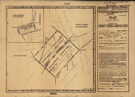
Plat map of the claim of George Wingfield (Yankee Doodle and Desert Rose Lodes), Esmeralda County (Nev.), 1910
Date
1910
Description
Plat map of the claim of George Wingfield (Yankee Doodle and Desert Rose Lodes), Esmeralda County (Nev.), 1910
Image
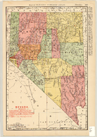
Map of Nevada Railroads, 1904
Date
1904
Description
Scale [ca. 1:1,710,720]. 1 in. equals 27 miles (W 120 --W 114 /N 42 --N 35 ) ; 1 map : col. 47 x 31 cm ; Relief shown by hachures ; Added title: Rand McNally's new business map of Nevada ; Shows range and township grid ; Shows railroads ; Color used to show boundaries of counties ; Originally published as pages 263 and 264 of Rand-McNally indexed atlas ; Additional copyright date: c1893 ;
Image
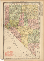
Map of Nevada Railroads, 1911
Date
1911
Description
Scale [ca. 1,710,720]. 1 in. = 27 miles (W 120 --W 114 /N 42 --N 35 ) ; 1 map : col. ; 47 x 31 cm ; Relief shown by hachures ; Title below scale: Rand McNally & Co.'s New business atlas map of Nevada ; Shows railroads ; Includes additional copyright date: c1893 ; Includes township and range grid ; Published as page 321 of Rand-McNally indexed atlas ;
Image
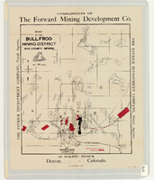
Map of the Bullfrog Mining District, Nye County (Nev.), 1905
Date
1905
Description
Scale [ca. 1:39,000. 1 in. to approx. 3,250 feet] ; 1 map : col. ; 45 x 38 cm ; Relief shown by hachures ; "Compliments of the Forward Mining Development Co." ; Properties owned by Patrick Investment Company are marked in red ; Shows railroads, roads, and pipelines ;
Image
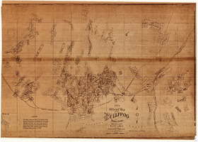
New official map of the Bullfrog Mining District, Nye County (Nev.), 1905
Date
1905
Description
Scale [ca. 1:16,800. 1 inch to approximately 1,400 feet] ; 1 map ; 74 x 109 cm ; Blueline print ; Scale almost illegible ; "Photo. lith. Britton & Rey." ; Photocopy? [United States : s.n., 199-?] ;
Image
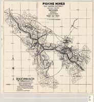
Map of the Pioche mines, Ely Mining District, Lincoln County (Nev.), 1909
Date
1909
Description
Scale unreadable ; 1 map ; 42 x 40 cm ; Photocopy. [United States ; s.n., 198-?] ; Includes township and range grid ; Includes wagon roads ;
Image
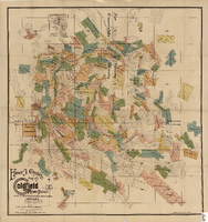
Elmer J. Chute's Map of Goldfield Mining District, Esmeralda and Nye Counties (Nev.), 1905
Date
1905
Description
Scale [ca. 1:20, 400. 1 in.=aprrox. 1,700 feet] ; 1 map : col. ; 60 x 58 cm ; Includes inset location map ; Includes township and range grid ;
Image
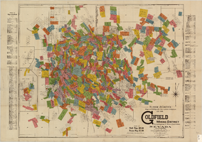
Elmer J. Chute's map of U.S. patent and location surveys in the Goldfield Mining District, Esmeralda and Nye Counties (Nev.), 1907
Date
1907
Description
Scale [ca. 1:22,800. 1 in. to approx. 1900 feet] ; 1 map : col. ; 66 x 82 cm., folded to 18 x 9 cm ; Includes index Includes township and range grid ;
Image
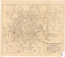
Elmer J. Chute's Diamond Map of the Goldfield Mining District, Esmeralda and Nye Counties (Nev.), 1907
Date
1907
Description
Elmer J. Chute's Diamond Map of the Goldfield Mining District, Esmeralda and Nye Counties (Nev.), 1907
Image
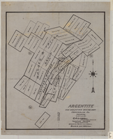
Map of Argentite: Red Mountain Mining District, Esmeralda County (Nev.),1908
Date
1908
Description
Scale [ca. 1:7,200]. 1 in. equals 600 feet ; 1 map : linen ; 46 x 39 cm
Image