Search Results
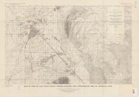
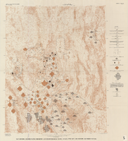
Map of part of Las Vegas Valley, Nevada, showing the approximate area of artesian flow, 1965
Date
1965
Description
At top of map: 'United States Department of the Interior, Geological Survey. Water supply paper 1780, plate 2.' At bottom of map: 'Base from U.S. Geological Survey Las Vegas (1952) and Henderson (1952) quadrangles.' 'Interior--Geological Survey, Washigton, D.C.--1965--W63358.' Relief shown by contours. Includes township and range lines. Thematic map. Scale 1:62,500 (W 115°15´--W 114°45´/N 36°15´--N 36°00´). Series: Water-supply paper (Washington, D.C.)1780. Originally published as plate 2 of Available water supply of the Las Vegas ground-water basin, Nevada, by Glenn T. Malmberg, published by the Geological Survey in 1965 as its Water-supply paper 1780.
Image

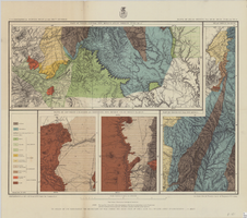
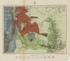
Geologic map and sections of area along Colorado River between Lake Mead and Davis Dam, Arizona and Nevada, 1963
Date
1963
Description
At top of map: 'United States, Department of Interior, Geological Survey. Professional Paper 374-E, plate 1.' In lower right corner of map: 'Geology mapped by C.R. Longwell.' Relief shown by contours. Includes seven colored cross-sections. Scale 1:125,000 (W 114°50´--W 114°20´/N 36°10´--N 35°10´). Series: Shorter contributions to general geology. Professional paper (Geological Survey (U.S.))374-E. Originally published as plate 1 in: Reconnaissance geology between Lake Mead and Davis Dam, Arizona-Nevada / by Chester R. Longwell, published by the U.S. Government Printing Office in 1963 in the series Shorter contributions to general geology and as Geological Survey professional paper 374-E.
Image
Map of part of North Central New Mexico atlas sheets 69(B), 69(D), 77(B) and 78(A), June 30, 1881
Date
1881-06-30
Description
39 x 52 cm. Relief shown by hachures and spot heights "Issued June 30, 1881." "Expeditions of 1873, 1878 and 1879 under the command of 1st. Lieut. Geo. M. Wheeler, Corps of Engineers U.S. Army." Geological map Probably originally published as part of the geological atlas which is an appendix to the Surveys' Report upon United States geographical surveys west of the one hundredth meridian. "Prof. John J. Stevenson, geological assistant." "By order of the honorable the Secretary of War under the direction of Brig. General A. A. Hunphreys, Chief of Engineers, U. S. Army." Original publisher: U.S. Geographical Surveys West of the 100th Meridian, Scale: 1 inch to 4 miles or 1: 253440.
Image
Map of parts of southern Colorado and northern New Mexico, atlas sheet no. 70(A), 1877
Date
1877-05-07
Description
37 x 50 cm. Prime meridian: Washington, D.C. Relief shown by hachures and spot heights. "Issued May 7th, 1877. 2nd ed., June 30th, 1881." "Atlas sheet no. 77(B)." "Expeditions of 1871 & 1786 under the command of 1st. Lieut. Geo. M. Wheeler, Corps of Engineers, U.S. Army." "Weyss, Herman & Lang, del." Probably originally published as part of the geological atlas which is an appendix to the Surveys' Report upon United States geographical surveys west of the one hundredth meridian. Geological map. "Prof. John J. Stevenson, geological assistant." Original publisher: U.S. Geographical Surveys West of the 100th Meridian, Scale: 1 inch to 4 miles or 1: 253440.
Image
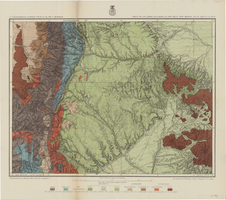
Generalized hydrogeologic map of lower Moapa-Lake Mead area, Clark County, Nevada, 1968
Date
1968
Description
'Hydrogeology by F.E. Rush, 1968. Geology adapted from Longwell and others 1965.' In lower left corner: ' Base: U.S. Geological Survey 1:250,000 topographic series; Las Vegas (1954).' At top of map: 'United States Department of the Interior, Geological Survey. Department of Conservation and Natural Resources, State of Nevada.' Relief shown by contoursIncludes township and range lines. Scale 1:250,000 (W 115°00´--W 114°15´/N 36°30´--N 36°15´). Series: Water resources-reconnaissance series report . Originally published as plate 1 in Water-resources appraisal of the lower Moapa-Lake Mead area, Clark County, Nevada / by F. Eugene Rush, published by State of Nevada Dept. of Conservation and Natural Resources in 1968 in volume 50 of the serial Water resources-reconnaissance series report.
Image
Map showing ground-water chemistry and hydrochemical facies, Nevada Test Site and vicinity, southern Nevada, 1965
Date
1965
Description
'United States Department of the Interior, Geological Survey. Professional paper 712-C, plate 3.' 'Prepared on behalf of the Atomic Energy Commission.' 'Base from U.S. Geological Survey Caliente, Death Valley, Goldfield, and Las Vegas, 1954.' 'Hydrochemistry by I. J. Winograd, 1965.' 'Interior--Geological Survey, Reston, Virginia--1975.' Relief shown by contours. Contour interval 200 feet. Shows township and range lines. Scale 1:250,000 (W 117°--W 115°/N 38°--N 36°). Series: Professional paper (Geological Survey (U.S.))712-C. Issued as plate 3 from U.S. Geological Survey professional paper 712-C, Hydrogeologic and hydrochemical framework, south-central Great Basin, Nevada-California, with special reference to the Nevada Test Site, by I.J. Winograd, and William Thordarson, published in 1975 by the U.S. Geological Survey.
Image
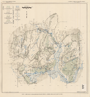
Map of Las Vegas artesian basin, Clark County, Nevada, April 1946 (Water Resources Bulletin no. 5, plate 5)
Date
1946-04
Description
'April, 1946.' 'Showing location of wells, springs, and boundary between valley fill and bedrock.' At top of map: 'United States Department of Interior, Geological Survey. Water resources bulletin no. 5, plate 5. ' 'State Engineer of Nevada.' At bottom of map: 'Map showing soils, land classification, and alkali concentration in part of Las Vegas Valley.' Includes range and township grid. Scale [ca. 1:71,597. 1 in. to approx. 1.13 miles]. Series: Water resources bulletin (Carson City, Nev.), no. 5. Originally published as plate 5 in Geology and water resources of Las Vegas, Pahrump, and Indian Spring Valleys, Clark and Nye Counties, Nevada by George B. Maxey and C.H. Jameson, which is number 5 of the Water resources bulletin published by the Nevada Office of the State Engineer.
Image
Map of part of north central New Mexico, atlas sheet no. 70(C), May 7th, 1877
Date
1877-05-07
Description
39 x 50 cm. Relief shown by hachures and spot heights. "Issued May 7th 1877-2nd ed. June 30th, 1881." "Expeditions of 1878 and 1879 under the command of 1st. Lieut. Geo. M. Wheeler, Corp. of Engineers U.S. Army." "Weyss Herman & Lang Del." Prime meridians: Washington, D.C. and Greenwich Geological map Probably originally published as part of the geological atlas which is an appendix to the Surveys' Report upon United States geographical surveys west of the one hundredth meridian. "Prof. John J. Stevenson, geological assistant." "By order of the honorable the Secretary of War under the direction of Brig. General A. A. Hunphreys, Chief of Engineers, U. S. Army." Original publisher: U.S. Geographical Surveys West of the 100th Meridian, Scale: 1 inch to 4 miles or 1: 253440.
Image

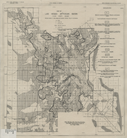
Map of the Las Vegas ground-water basin, Clark, Nye, and Lincoln Counties, Nevada, 1965
Date
1965
Description
At top of map: 'United States Department of the Interior, Geological Survey. Water-supply paper 1780, plate 1.' At bottom of map: 'Base from Army Map Service sheets NJ 11-9, NJ 11-12, and NI 11-3 (1947).' 'Boundary between bedrock and alluvium in Clark County, Nev., compiled by Ben Boyer, E. H. Pampeyan and C. R. Longwell. In Lincoln and Nye Counties, contact determined from aerial photographs.' 'Interior--Geological Survey, Washington, D.C.--1965--W63358.' Includes township and range lines.Relief shown by contours. Thematic map. Scale 1:250,000 (W 116°--W 114°45´/N 37°00´--N 35°30´). Series: Water-supply paper (Washington, D.C.), 1780. Originally published as plate 1 of Available water supply of the Las Vegas ground-water basin, Nevada, by Glenn T. Malmberg, published by the Geological Survey in 1965 as its Water-supply paper 1780.
Image

Hydrogeologic map of Nevada Test Site and vicinity, southern Nevada, 1965
Date
1965
Description
At top of map: ' United States Department of the Interior, Geological Survey. Professional paper 712-C, plate 1. Prepared on behald of the U.S. Atomic Energy Commission.' At bottom of map: 'Base from U.S. Geological Survey, Caliente, Death Valley, Goldfield and Las Vegas, 1954. 100,00-foot grid based on Nevada coordinate system, central zone.' 'Hydrogeology by I. J. Winograd, 1965; geology by William Thordarson.' Relief shown by contours and spot heights. Shows township and range lines. Includes diagram of downward and upward cross-flow of water. Includes bibliographical references and index. Contour interval 200 feet. Scale 1:250,000 (W 117°--W 115°/N 38°--N 36°). Series: Professional paper (Geological Survey (U.S.), 712-C. Issued as plate 1 from Hydrogeologic and hydrochemical framework, south-central Great Basin, Nevada-California with special reference to the Nevada Test Site. Prepared on behalf of the U.S. Atomic Energy Commission by Isaac J. Winograd and William Thordarson. Published 1975 by U.S. Govt. Print. Off. in Washington.
Image