Search Results
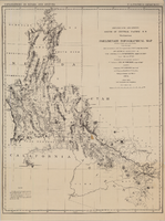
Map of explorations and surveys south of the Central Pacific Railroad made by the U.S. Army Corps of Topographical Engineers, 1871
Date
1871
Description
'Preliminary topographical map embracing in skeleton a portion only of the notes from surveys made in accordance with Par.II Special Orders No. 109 War Dept., March 18th, 1871 and letter of instructions of Brig. General A.A. Humphreys, Chief of Eng'rs. dated March 23rd, 1871. Conducted under the immediate direction of 1st Lieutenant Geo. M. Wheeler, Corps of Eng'rs., assisted by 1st Lieutenant D.W. Lockwood, Corps of Eng'rs. and 2nd Lieutentant D.A. Lyle, 2nd U.S. Artillery, during the summer and fall of 1871. Louis Nell, chief topographer and draughtsman.'' At head of map: 'Explorations in Nevada and Arizona. U.S. Engineer Department.' In lower left corner: 'Note: This map is a hasty and partial compilation from the topographical data already received, many still remaining en route. Upon it is projected in skeleton the groundwork of the area examined. All points except the prominent astronomical positiions are subject to lsight modification upon the final map.' Shows area through central Nevada, eastern California, and central Arizona. Relief shown by hachures. Published by the War Dept. Scale [ca. 1:1,520,640]. 1 in. to 24 miles (W 118°--W 109°/N 41°--N 32°).
Image
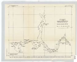
Map of Lake Mead, Arizona-Nevada, showing locations of gages used to establish water-stage elevations during 1947-49 survey
Date
1960
Description
Scale [ca. 1:274,349. 1 in. to approx. 4.33 miles] (W 114°54?--W 113°54?/N 36°36?--N 35°58?). 1 map ; 27 x 34 cm. United States Dept. of the Interior, Geological Survey
Image

Map of California, territories of New Mexico, Arizona, Colorado, Nevada and Utah, circa 1863
Date
1861 to 1865
Description
40 x 62 cm. Relief shown by hachures and spot heights. Prime meridians: Greenwich and Washington. "Historical and statistical view of the United States, 1860"--Verso. Atlas page numbers at top: 58-59. Arizona became a territory in 1863, and Nevada became a state on October 31, 1864, so this map was either published in 1863 or in 1864 before the end of October. Original publisher: Johnson and Ward.
Image
Soil map, Nevada, Moapa Valley sheet, 1923
Date
1923
Archival Collection
Description
'U.S. Department of Agriculture, Bureau of Chemistry and Soils; C.A. Browne, Acting Chief; Curtis F. Marbut, in charge, Soil Survey.' 'Macy H. Lapham, Inspector, District 5. Soils surveyed by F.O. Youngs, in charge, and E.J. Carpenter.' 'Field Operations, Bureau of Soils, 1923.' 'A, Hoen & Co. Lith. Baltimore, Md.' Shows township and range lines. Scale [1:63,360]. 1 in. = 1 mile (W 114°45´--W 114°18´/N 36°51´--N 36°24´). Library's copy has hand-written notes and has hand-drawn maps and notes on verso.
Image
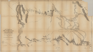
Map based on reconnaissance of the Zuñi, Little Colorado and Colorado Rivers in 1851 by U.S. Corps of Topographical Engineers
Date
1852
Description
Transcribed from the original: 'Made in 1851 under the direction of Col J.J. Abert, Chief of Corps Topographical Engineers, by BVT. Capt. L. Sitgreaves, T.E., assisted by Lieut. J.G. Parke, T.E., and Mr. M.H. Kern. Drawn by R.H. Kern, 1852.' 'Gila River from a reconnaissance by Maj. Emory, Topographical Engrs. Colorado River below Camp Yuma from a reconnaissance by Lt. Derby Topographical Engrs.' Shows Indian villages and forts. Upper right corner partially missing. Scale [ca. 1:650,000]. Scale of 10 miles to one inch.' 'Ackerman Lith.: 379 Broadway, N.Y.'
Image

Map of California, with territories of Utah, Nevada, Colorado, New Mexico, and Arizona, 1864
Date
1864
Description
40 x 62 cm. Relief shown by hachures. Prime meridians: Greenwich and Washington. Page numbers at top: 58-59. "Entered according to act of Congress in the year 1864 by A. J. Johnson in the Clerk's Office of the District Court of the United States for the Southern District of New York." Original publisher: Johnson and Ward.
Image
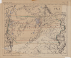
Map of territory of Utah, 1857
Date
1857
Description
31 x 39 cm. Relief shown by hachures and spot heights. "Entered in Sta. Hall London & according to act of Congress in the year 1857 by H.D. Rogers in the Clerks Office of the District Court of Massachusetts." Includes proposed Pacific railway routes. In upper margin: Atlas of United States &c., 13. Original publisher: John Murray, Scale: 3,450,000 of nature, 54 1.
Image
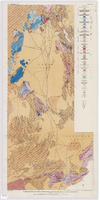
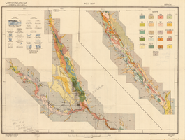
Geologic map of the Atomic Energy Commission Nevada Proving Grounds Area, Nye and Clark Counties, Nevada, 1952
Date
1952
Description
'At top of map: ' United States Department of the Interior. Geological Survey.' ' Bulletin 1021, Plate 32.' At bottom of map: 'Geology by Donald E. Hibbard and Mike S. Johnson, 1952.' 'Base from USAF Aeronautical Chart and Information Service, April 1952.' 'Interior--Geological Survey, Washington, D.C. MR-3767.' Scale 1:63,360 (W 116°10--W 115°55/N 37°15--N 36°40)
Geological Survey bulletin, 1021
Image

Topographic map of Nevada-California, Las Vegas quadrangle, March 1908
Date
1908-03
Description
'Edition of Mar. 1908.' 'E.M. Douglas, geographer in charge; Topography and triangulation by R.H. Chapman, B.D. Stewart, J.E. Blackburn, and D.F.C. Moor. Surveyed in 1906-1907.' Scale 1:250,000 (W 116°00--W 115°00/N 37°00--N 36°00). Relief shown by contours and spot heights. Title in lower-right corner: Las Vegas. Contour interval 100 feet. Datum is mean sea level. "Topography"--Center of top margin. Text about the Topographic Maps of the United States series and symbols used on map on verso. U.S. Geological Survey
Text
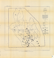
Map showing chemical diagrams representing quality of water in Clark and Nye counties, Nevada, 1963
Date
1963
Description
'T.E. Eakin, S.L. Schoff, and P. Cohen, 1963.' 'Department of the Interior, United States Geological Survey, TEI-833.' 'Prepared in cooperation with the U.S. Atomic Energy Commission.' Scale 1:500,000 (W 117°00´--W 115°00´/N 38°30´--N 36°30´). Originally published as figure 3 in Regional hydrology of a part of southern Nevada : a reconnaissance / by Thomas E. Eakin, Stuart L. Schoff, and Philip Cohen, published by the U.S. Geological Survey in 1963 as number 833 of the Trace elements investigation report.
Image