Search Results
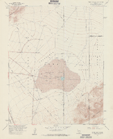
Topographic map of Frenchman Flat quadrangle, Nevada, 1960
Date
1960
Description
'Mapped, edited, and published by the Geological Survery in cooperation with the Atomic Energy Commission. Control by USGS, USC&GS, USCE, and Atomic Energy Commission. Topography from aerial photographs by photogrammetric methods. Aerial photographs taken 1959. Field check 1960.' Scale 1:24,000 polyconic projection (W 116°00'00"--W 115°52'30"/N 36°52'30"--N 36°45'00"). Series: 7.5 minute series (topographic). Relief shown by contours and spot heights. Filing title: Frenchman Flat, Nev. Contour interval 20 feet. opography rom . Includes quadrangle location map. Interior--Geological SurveyFor sale by the U.S. Geological Survey
Image
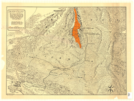
Map of irrigable areas near Boulder Dam, February 20, 1935
Date
1935-02-20
Archival Collection
Description
'Drawn by C.G.C.' 'Carson City, Nevada, Feb. 20, 1935. No. 4.' 'Adapted from Bureau of Reclamation's General map of irrigable areas.'
Image
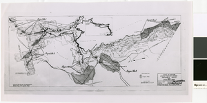
Map and operational diagram, lower Colorado River, Lees Ferry to Gulf of California, May 1957
Date
1957-05
Description
83 x 43 cm. "Drawing no. 423-300-59." "May 1957." "Supercedes 423-306-183." "Map compiled from Coast and Geodetic Survey sectional aeronautical charts, and Bureau of Reclamation data." Includes index to gaging stations. Shows dams, canals, levees, pumping plants, etc. Insets: [Salton Sea]--Operational diagram, no scale. "Revised June 1967." Original publisher: Bureau of Reclamation, Region 3.
Image
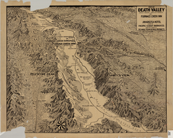
Map of Death Valley showing principal points of interest and Furnace Creek Inn, and Amargosa Hotel, circa 1930s
Date
1930 to 1939
Archival Collection
Description
Relief shown by landform drawings and spot heights. Oblique perspective map. Library's copy is missing lower left corner and piece in upper margin near left corner
Image

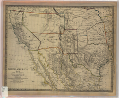
Map of California, Utah, Nevada, Colorado, New Mexico and Arizona, 1864
Date
1864
Description
'Johnson's California, with Utah, Nevada, Colorado, New Mexico, and Arizona, published by Johnson and Ward.' 'Entered according to Act of Congress in the Year 1864 by A.J. Johnson in the Clerks Office of the District Court of the United States for the southern district of New York.' Atlas page numbers in upper margin: 66-67. This is probably plate 67 from Johnson's New Illustrated Family Atlas, published in New York by Johnson & Ward in 1864. Shows natural features, locations of Indian tribes, proposed railroad routes, routes of explorers, trails, county boundaries and populated places ; "." ; Relief shown by hachures ; Prime meridians: Greenwich and Washington ; In top margin: 66-67 ; Hand colored ; On verso: Historical and statistical view of Mexico and central America (p. 79) and Historical and statistical view of the United States, 1860 (p. 78) Scale [ca. 1:3,484,800]. 1 in. to ca. 55 miles (W 124°--W 102°/N 42°--N 32°)
Text
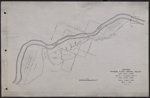
Map of proposed flood control project on the Virgin River in Clark County, Nevada, March, 1934
Date
1934-03
Archival Collection
Description
'Map no. 7 to accompany report on flood control survey. Made by Graham S. Quate. March 1934. Drawn by T.K.' Scale [ca. 1:15, 600. 1 in.=approx. 1,300 feet]. Relief shown by hachures. North oriented to upper right corner. Library's copy has hand-drawn map and notes in pencil on verso.
Image
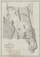
Map of the Great Salt Lake and adjacent country in the territory of Utah, 1850
Date
1849 to 1850
Description
108 x 75 cm. Map part hand colored. Relief shown by hachures and depths shown by soundings. Accompanies U.S. Army. Corps of Topographical Engineers. Exploration and survey of the valley of the Great Salt Lake of Utah. "Map of the Great Salt Lake and adjacent country in the Territory of Utah. Surveyed in 1849 and 1850, under the orders of Col. J. J. Abert, Chief of the Topographical Bureau, by Capt. Howard Stansbury of the Corps of Topographical Engineers, aided by Lieut. J. W. Gunnison Corps Topographical Engineers and Albet Carrington. Drawn by Lieut. Gunnison and Charles Preuss. Ackerman lith 379 Broadway N. Y." Original publisher: Ackerman Lith. Scale: 1:240,000.
Image
Map of Utah, New Mexico, Texas, California, Indian territory, and the northern states of Mexico, 1852
Date
1852-01-01
Description
At head of title: 'North America, sheet XV.' 'Published under the superintendence of the Society for Diffusion of Useful Knowledge.' At bottom center of map:'London, Charles Knight, Jany. 1st, 1852.' At bottom right of map: ' J. & C. Walker Sculpt.' Scale [1:7,500,000] 1 degree to 68.89 English miles (W 125°--W 92°/N 43°30?--N 22°30?). Relief shown by hachures. Atlas page number in lower margin: 144. Boundaries hand colored. Includes notes, locations of Indian tribes, population statistics. Charles Knight.
Image
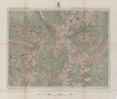
Map of economical features of Southwest Colorado, San Juan mining region, circa 1877
Date
1872 to 1880
Description
37 x 49 cm. Relief shown by hachures and spot heights. "Atlas sheet no. 61(C)." "Expeditions of 1874 & 1875 under the command of 1st. Lieut. Geo. M. Wheeler, Corps of Engineers, U.S. Army." "Louis Nell, del." "By order of the honorable the Secretary of War." "Under the direction of Brig. General A. A. Hunphreys, Chief of Engineers, U. S. Army." Original publisher: U.S. Geographical Surveys West of the 100th Meridian, Scale: 1 inch to 2 miles or 1: 126720.
Image
Map of Death Valley and surrounding areas in southern California, southern Nevada and Arizona, 1930
Date
1930
Archival Collection
Description
Col. ; 51 x 69 cm. Oblique perspective map. Relief shown by landform drawings and spot heights. North is toward upper-right corner. "1M--10-33--1846--A.P.Co." printed in lower left corner. Published by the Pacific Coast Borax Company, Los Angeles, California, 1930. Signed by Howard Burke near lower right corner.
Image