Search Results
LVLWC 782 - Las Vegas, Nevada - constructing 1895 feet of 6-inch cast iron water mains
Date
1954
Archival Collection
Description
Series 2. Las Vegas Land and Water Company -- General Manager, Manager of Properties, and Manager of Industrial Development in Los Angeles, California -- Right-of-way and Property Documents
Mixed Content
LVLWC 783 - Las Vegas, Nevada - constructing 700 feet of 6-inch cast iron water main
Date
1954
Archival Collection
Description
Series 2. Las Vegas Land and Water Company -- General Manager, Manager of Properties, and Manager of Industrial Development in Los Angeles, California -- Right-of-way and Property Documents
Mixed Content
LVLWC 784 - Las Vegas, Nevada - constructing 860 feet of 8-inch cast iron water main on Oakey Blvd.
Date
1954
Archival Collection
Description
Series 2. Las Vegas Land and Water Company -- General Manager, Manager of Properties, and Manager of Industrial Development in Los Angeles, California -- Right-of-way and Property Documents
Mixed Content
LVLWC 785 - Las Vegas, Nevada - constructing 310 feet of 8-inch and 440 feet of 6-inch water mains
Date
1954
Archival Collection
Description
Series 2. Las Vegas Land and Water Company -- General Manager, Manager of Properties, and Manager of Industrial Development in Los Angeles, California -- Right-of-way and Property Documents
Mixed Content
Nevada State Museum archaeology reports
Date
1963-11
1963-10
1963-09
1963-08
1963-07
1963-06
1963-05
1963-04
1963-03
1963-08-02
1963-08-06
Archival Collection
Description
Charles Rozaire's monthly reports as curator of archaeology at the Nevada State Museum. Also included is a site survey record from Washoe, a hand drawn site exacavation map, an archaeological stratigraphy record, a daily field record, and a pictograph record from Wall Canyon Ranch.
Text
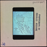
Photographic slide of "The North American Desert" map, circa 1950s-1960s
Date
1950 (year approximate) to 1969 (year approximate)
Archival Collection
Description
A map showing the locations of North American desert subdivisions.
Image

Map of Amargosa Municipal Center: photographic print
Date
1880 (year approximate) to 1990 (year approximate)
Archival Collection
Description
Artist's rendering of Amargosa Municipal Center, Amargosa, Nevada. The architect is Alton Dean Jensen.
Image

David Weide holding up a map: photographic print
Date
1880 (year approximate) to 1990 (year approximate)
Archival Collection
Description
Mr. David Weide, a UNLV Professor in the Geoscience Department, holding up a map.
Image
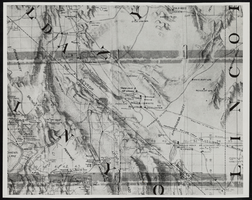
Topographic map of Nevada and California: map
Date
1950 (year approximate) to 1960 (year approximate)
Description
From the Nan Doughty Photograph Collection (PH-00240). Showing Death Valley, California, Amargosa Valley, Nevada, and the Bullfrog-Rhyolite area.
Image
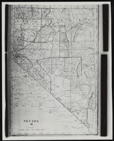
Topographic map of Nevada: map
Date
1881
Description
From the Nan Doughty Photograph Collection (PH-00240)
Image