Search Results
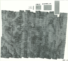
Index to aerial photographs of Goldfield, Nevada: photographic print
Date
1952
Archival Collection
Description
From the Army Mapping Service Aerial Photographs of Southern and Western Nevada (PH-00285). Aerial photographs, composites, and indices. Geological Survey, Army Map Service.
Image
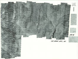
Index to aerial photographs of Las Vegas, Nevada: photographic print
Date
1952 to 1954
Archival Collection
Description
From the Army Mapping Service Aerial Photographs of Southern and Western Nevada (PH-00285). Aerial photographs, composites, and indices. Geological Survey, Army Map Service. Western US. Project No. 109. Area G.
Image
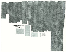
Index to aerial photographs of Death Valley, Nevada: photographic print
Date
1952
Archival Collection
Description
From the Army Mapping Service Aerial Photographs of Southern and Western Nevada (PH-00285). Aerial photographs, composites, and indices. Geological Survey, Army Map Service. Western AMS. Project No. 109. Area G.
Image
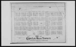
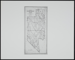
Clark's Las Vegas Townsite, Lincoln County, Nevada: map
Date
1900 (year approximate) to 1999 (year approximate)
Archival Collection
Description
From the UNLV Libraries Single Item Accession Photograph Collection (PH-00171)
Image
Map of Lincoln County before Clark County was created, Nevada: map
Date
1900 (year approximate) to 1999 (year approximate)
Archival Collection
Description
From the UNLV Libraries Single Item Accession Photograph Collection (PH-00171)
Image
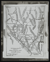
Plat showing country tributary to San Pedro, Los Angeles, and Salt Lake: map
Date
1900 to 1999
Archival Collection
Description
From the UNLV Libraries Single Item Accession Photograph Collection (PH-00171). Railroad in southern Nevada
Image
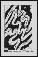
View of folding, ore, and shale: photographic print
Date
1910 (year approximate) to 1930 (year approximate)
Archival Collection
Description
From the Chester R. Longwell Photograph Collection (PH-00311)
Image
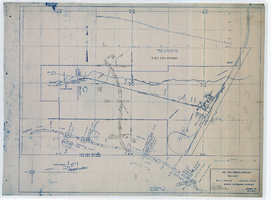
Map showing location of 24" C.I. pipeline in Las Vegas, Nevada, circa 1943
Date
1941 to 1945
Archival Collection
Description
Scale [ca. 1:120]. 1 in. to 10 feet.--Scale [ca. 1:1,200.] 1 in. to 100 feet.--Scale [ca. 1:7,200. 1 in.=approx. 600 feet] --Scale [ca. 1:7,200]. 1 in.=600 feet. Vertical scale [ca. 1:240]. 1 in.=20 feet. 1 map : blueline ; 58 x 74 cm. At head of title: As constructed drawing. "W.O.-8577." "Drawing no. 41092." "City of Las Vegas Highway transcribed from drwg. approved Harlan Brown, City Engineer-Sept. 1943-H.D.A 12/31/43"--Hand-written note. Map of the water pipes for Las Vegas. Includes the buildings in the railroad yard, a detailed map of a section of the pipe, a profile of the 24 inch C.I. pipe, and a map of the point of diversion. Date of detailed map is 5-20-1930. From the Union Pacific Railroad Collection. Los Angeles & Salt Lake Railroad Company, Office of Chief Engineer
Image
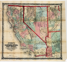
Bancroft's map of California, Nevada, Utah and Arizona, 1873
Date
1873
Description
Hand colored ; Relief shown by hachures and spot heights ; Prime meridian: Washington, D.C ; Shows railroads, proposed railroads and wagon roads, etc. Published by A.L. Bancroft & Company. Scale [ca. 1:1,520,640]. 1 in. to 24 miles (W 124°--W 111°/N 42°--N 32°).
Image
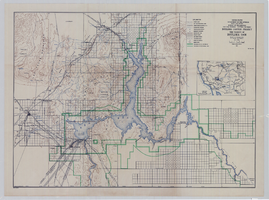
Topographic map of Boulder Canyon Project, Boulder Dam area, 1940
Date
1940
Description
Scale [ca. 1:221,760. 1 in. to approx. 3.5 miles] ; 1 map : col. ; 51 x 71 cm ; Relief shown by contours and spot heights ; Includes township and range grid ; "Map no. 40-40" ; Includes index map ; Shows power lines, triangulation stations, boundary monuments, roads, telephone lines, mines, bench marks, etc. ; U.S. Dept. of the Interior, Bureau of Reclamation
Image