Search Results

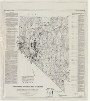
Earthquake epicenter map of Nevada, December 1964
Date
1964-12
Description
Scale 1:1,000,000 (W 120°--W 114°/N 42°--N 35°). Title in upper right margin: Earthquake epicenter map ; "Nevada earthquake epicenters for the period from about 1852 to 1961 are plotted on the accompanying map." ; "Contour interval 1,000 feet." ; "Supported by grant no. AF-AFOSR-62-285 of the Air Force of Scientific Research." ; "December 1964." ; "Base from NBM Map 17." ; "One million scale set." ; Includes bibliographical references ; Includes text and index. Nevada Bureau of Mines, University of Nevada
Text
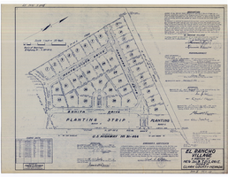
Plat map of El Rancho Village, Clark County, Nevada, July 28, 1942
Date
1942-07-28
Description
Map of housing subdivision outside the Las Vegas city limits. 'Approved this 28 day of July1942, by the City Planning Commission of the City of Las Vegas, County of Clark, Nevada. Approved this 28 day of July 1942, by the County Planning Commission of the County of Clark, State of Nevada.' Blueline print. Oriented with north to the upper right. Embossed with Engineering Certificate seal of Frank D. Rathburn, which states. 'Survey completed August 4, 1942.' 'Book II, page 53' hand printed in lower right corner. Signed by Clark County, Nevada Notary Public and other coumty officials and officials of El Rancho Village. Published by Office of F.D. Rathbun. Scale [ca. 1:600]. 1 inch to 50 feet
Text

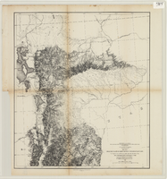
Maps of explorations and surveys for a railroad route from the Mississippi River to the Pacific Ocean, 1855
Date
1855
Description
Map no. 1. From the valley of Green River to the Great Salt Lake -- Map no. 2. From the Great Salt Lake to the Humboldt Mountains -- Map no. 3. From the Humboldt Mountains to the Mud Lakes -- Map no. 4. From the valley of the Mud Lakes to the Pacific Ocean. 'From explorations and surveys made under the direction of the Hon. Jefferson Davis, Secretary of War, by Capt. E.G. Beckwith, 3rd Artillery, E.G. Egloffstein, topographer for the route. 1855.' ''Selmar Siebert's Engraving & Printing Establishment, Washington, D.C.' Published by the War Dept. Scale 1:760,320. 12 miles to 1 in. Relief shown by hachures and spot heights.
Image
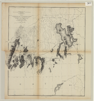
From the valley of Green River to the Great Salt Lake
Date
1855
Description
'From explorations and surveys made under the direction of the Hon. Jefferson Davis, Secretary of War, by Capt. E.G. Beckwith, 3rd Artillery, E.G. Egloffstein, topographer for the route. 1855.' ''Selmar Siebert's Engraving & Printing Establishment, Washington, D.C.' Published by the War Dept. Scale 1:760,320. 12 miles to 1 in. Relief shown by hachures and spot heights.
Image
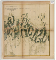
From the Great Salt Lake to the Humboldt Mountains
Date
1855
Description
'From explorations and surveys made under the direction of the Hon. Jefferson Davis, Secretary of War, by Capt. E.G. Beckwith, 3rd Artillery, E.G. Egloffstein, topographer for the route. 1855.' ''Selmar Siebert's Engraving & Printing Establishment, Washington, D.C.' Published by the War Dept. Scale 1:760,320. 12 miles to 1 in. Relief shown by hachures and spot heights.
Image
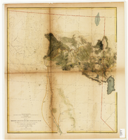
From the Humboldt Mountains to the Mud Lakes
Date
1855
Description
'From explorations and surveys made under the direction of the Hon. Jefferson Davis, Secretary of War, by Capt. E.G. Beckwith, 3rd Artillery, E.G. Egloffstein, topographer for the route. 1855.' ''Selmar Siebert's Engraving & Printing Establishment, Washington, D.C.' Proposed railroad lines highlighted in red. 'Line explored in 1854' highlighted in yellow. Published by the War Dept. Scale 1:760,320. 12 miles to 1 in. Relief shown by hachures and spot heights.
Image
From the valley of the Mud Lakes to the Pacific Ocean
Date
1855
Description
'From explorations and surveys made under the direction of the Hon. Jefferson Davis, Secretary of War, by Capt. E.G. Beckwith, 3rd Artillery, E.G. Egloffstein, topographer for the route. 1855.' ''Selmar Siebert's Engraving & Printing Establishment, Washington, D.C.' Proposed railroad lines highlighted in red and yellow. Published by the War Dept. Scale 1:760,320. 12 miles to 1 in. Relief shown by hachures and spot heights.
Image
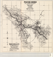
Map of Pioche mines, Ely Mining District, Lincoln County, Nevada, 1909
Date
1909
Description
'A.D. Knowlton, Mining Engineer, Pioche, Nevada; H.H. Snelgrove, Draftsman, Salt Lake City, Utah. Copyright 1909 Rufus K. Cobb.' Includes township and range grid; Includes wagon roads. Published by R.K. Cobb. Photocopy.
Image