Search Results

Map of the Las Vegas Strip, May 1950
Date
1950-05
Description
Scale [ca. 1:10,200. 1 in. to approx. 850 ft.] ; 1 map : col. ; 54 x 28 cm ; Cadastral map ; "May 1950." Campbell Realty.
Image

Map of Las Vegas Valley showing artesian wells, circa 1920
Date
1918 to 1922
Description
Scale not given ; 1 map ; 66 x 55 cm ; Blueline print ; Cadastral map ; Includes township and range grid ; Includes quotations McWilliams?
Image
Lillian Gladys Yeager Berg and William Henry Berg following their marriage in Shoshone Canyon, 1914
Level of Description
File
Archival Collection
Nye County, Nevada Photograph Collection
To request this item in person:
Collection Number: PH-00221
Collection Name: Nye County, Nevada Photograph Collection
Box/Folder: Folder 42
Collection Name: Nye County, Nevada Photograph Collection
Box/Folder: Folder 42
Archival Component
Following the Old Trail north of emigrant Pass in California, east of Pahrump Valley, October 1967
Level of Description
File
Archival Collection
Sherwin "Scoop" Garside Papers
To request this item in person:
Collection Number: MS-00342
Collection Name: Sherwin "Scoop" Garside Papers
Box/Folder: Box 01
Collection Name: Sherwin "Scoop" Garside Papers
Box/Folder: Box 01
Archival Component
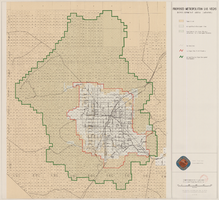
Map showing proposed metropolitan Las Vegas development area, June 24, 1997
Date
1997-06-24
Description
'Data sources: Advanced Planning Division, Clark County, Nevada.' 'Comprehensive Planning, Advanced Planning Division.' 'June 24, 1997.' Shows federal land, metropolitan Las Vegas development area, Las Vegas urban growth boundary and section lines. Scale [ca. 1:154,056. 1 inch to approx. 12,838 feet].
Image
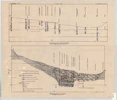
Cross-sections of wells and aquifers in the Las Vegas Valley, circa 1946
Date
1943 to 1949
Description
2 map sections on 1 sheet. Originally published as plate 6 in Geology and water resources of Las Vegas, Pahrump, and Indian Spring Valleys, Clark and Nye Counties, Nevada by George B. Maxey and C.H. Jameson, which is number 5 of the Water resources bulletin published by the Nevada Office of the State Engineer. Shows permeable and impermeable materials, wells, and aquifers.
Text
#02454: Cancer Society Cocktail Party Following Louisville Game (Gentry, Bobbie), 1977 February 12
Level of Description
File
Archival Collection
University of Nevada, Las Vegas Creative Services Records (1970s)
To request this item in person:
Collection Number: PH-00388-01
Collection Name: University of Nevada, Las Vegas Creative Services Records (1970s)
Box/Folder: N/A
Collection Name: University of Nevada, Las Vegas Creative Services Records (1970s)
Box/Folder: N/A
Archival Component
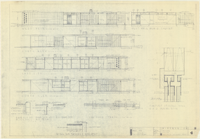
Architectural drawings of a residential home in Las Vegas, Nevada, November 2, 1962
Date
1963-11-02
Description
Exterior elevations and details for a residential home on Fifth Place in Las Vegas, Nevada. Sheet no. 4. "Drw. D.H."
Architecture Period: Mid-Century ModernistImage
Dashiell, Benjamin Douglas, "Counselor Effectiveness on Intake and Follow-up at a Mental Health Center", 1974 December
Level of Description
Item
Archival Collection
University of Nevada, Las Vegas Theses, Dissertations, and Honors Papers
To request this item in person:
Collection Number: UA-00082
Collection Name: University of Nevada, Las Vegas Theses, Dissertations, and Honors Papers
Box/Folder: Box 424
Collection Name: University of Nevada, Las Vegas Theses, Dissertations, and Honors Papers
Box/Folder: Box 424
Archival Component
Duncan, Gail B, "A Follow-up Survey of Clients Rehabilitated in the Cedar City District in 1970", 1972 Fall
Level of Description
Item
Archival Collection
University of Nevada, Las Vegas Theses, Dissertations, and Honors Papers
To request this item in person:
Collection Number: UA-00082
Collection Name: University of Nevada, Las Vegas Theses, Dissertations, and Honors Papers
Box/Folder: Box 427
Collection Name: University of Nevada, Las Vegas Theses, Dissertations, and Honors Papers
Box/Folder: Box 427
Archival Component