Search Results
, page 16")
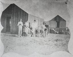
Photograph of the Lake family's home on on Third Street, Las Vegas, circa early 1900s
Date
1905 to 1939
Archival Collection
Description
Black and white image of several people posing for a photo outside the Lake family's home on North 3rd Street in Las Vegas.
Image
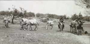
Photograph of a two men and a pack of donkeys, Las Vegas Ranch, circa early 1900s
Date
1900 to 1939
Archival Collection
Description
Black and white image of two men and a pack of donkeys at the Las Vegas Ranch. Site Name: Las Vegas Ranch (Las Vegas, Nev.)
Image
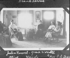
Film transparency of five women sitting in a room, Las Vegas, circa early 1900s
Date
1904 to 1939
Archival Collection
Description
Black and white image of several women with the following handwritten description: "Julia Russel, Grace Worrell, Olive, Wanda, our S.S. Teacher." Note: Image is from a family photo album that was loaned to UNLV Libraries Special Collections and returned to the family on July 17, 1984.
Image
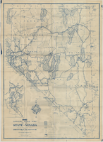
Official road map of the State of Nevada, 1941
Date
1941
Archival Collection
Description
Compiled and published for free distribution by the Department of Highways, Carson City, Nevada. Board of Directors: Governor E.P. Carville, Chairman; Gray Mashburn, Member; Henry Schmidt, Member; Robert A. Allen, State Highway Engineer. Nevada Department of Highways
Image
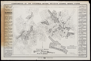
Map of Rawhide Mining District, Nevada, circa 1908
Date
1905 to 1911
Description
'Numbers and black lines show locations of the principal mines, prospects and leases of Rawhide.' 'Compiled by Engraving Department of the Goldfield Review. Olmstead and Rich, Mining Engineers, Goldfield, Nevada.' At top of map: 'Compliments of the Goldfield Review, Nevada's leading mining paper.' Includes index. Published by Goldfield Review Press.
Text

Map showing railroads in Nevada, 1911
Date
1911
Description
Relief shown by hachures. Title below scale: Rand McNally & Co.'s New business atlas map of Nevada. Shows railroads. Includes township and range grid. Includes index to principal cities with population statistics. Includes township and range grid. Index to Nevada counties, lakes, mountains, rivers, towns, etc. on verso. Published by Rand McNally & Co. Scale [ca. 1,710,720]. 1 in. = 27 miles (W 120°--W 114°/N 42°--N 35°). Published as page 321 of Rand-McNally indexed atlas.
Text
Ladouceur, Robert. The Level of Involvement and the Timing of Betting in Roulette, Journal of Psychology, approximately 1900 to 1999
Level of Description
File
Archival Collection
UNLV Libraries Collection of Articles on Gaming and Las Vegas, Nevada Topics
To request this item in person:
Collection Number: MS-00626
Collection Name: UNLV Libraries Collection of Articles on Gaming and Las Vegas, Nevada Topics
Box/Folder: Box 06
Collection Name: UNLV Libraries Collection of Articles on Gaming and Las Vegas, Nevada Topics
Box/Folder: Box 06
Archival Component
Journal articles: subjects relating to Mark R. Harrington and later excavations by archaeologists, includes Harrington's published documents on the Moapa Valley, 1925-1936
Level of Description
File
Archival Collection
Pueblo Grande de Nevada Manuscript Collection
To request this item in person:
Collection Number: MS-00208
Collection Name: Pueblo Grande de Nevada Manuscript Collection
Box/Folder: Box 01
Collection Name: Pueblo Grande de Nevada Manuscript Collection
Box/Folder: Box 01
Archival Component
Map, city of Henderson, Nevada, August 1, 1955
Date
1955-08-01
Description
'Compiled by Pioneer Title Insurance & Trust Company.' '8/1/55.' Includes street index.
Image