Search Results
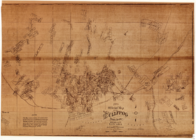
Map of the Bullfrog Mining District, Nye County, Nevada, circa 1905
Date
1901 to 1909
Description
'Compiled by Geo. E. Sherer and W.B. Milliken, miners and surveyors, Bull Frog, Nye Co., Nevada.' 'Photo. Lith. Britton & Rey, S.F.' Scale [ca. 1:16,800. 1 inch to approximately 1,400 feet]. Blueline print.
Image
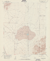
Topographic map of Frenchman Flat quadrangle, Nevada, 1960
Date
1960
Description
'Mapped, edited, and published by the Geological Survery in cooperation with the Atomic Energy Commission. Control by USGS, USC&GS, USCE, and Atomic Energy Commission. Topography from aerial photographs by photogrammetric methods. Aerial photographs taken 1959. Field check 1960.' Scale 1:24,000 polyconic projection (W 116°00'00"--W 115°52'30"/N 36°52'30"--N 36°45'00"). Series: 7.5 minute series (topographic). Relief shown by contours and spot heights. Filing title: Frenchman Flat, Nev. Contour interval 20 feet. opography rom . Includes quadrangle location map. Interior--Geological SurveyFor sale by the U.S. Geological Survey
Image
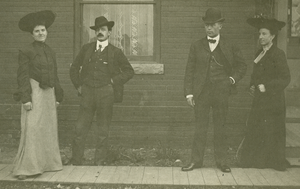
Photograph of Emma (Peggy) Marie (Schaefle) Schuyler and William Norton Schuyler (left), with Jack (John) and Caroline Heaton., Denver, Colorado, January, 1900
Date
1900-01
Archival Collection
Description
Emma (Peggy) Marie (Schaefle) Schuyler and William Norton Schuyler (left), with Jack (John) and Caroline Heaton. In Denver, Colorado. Caroline is Emma's sister (Caroline Agnes (Schaefle) Heaton), and was prominent in Las Vegas real estate market in 1930s-40s. Caroline established the first Las Vegas radio station KGIX in 1928 in the "country" at the current location of 9th and Mesquite Streets.
Image
University of Nevada, Las Vegas Photograph Collection
Identifier
PH-00062
Abstract
The University of Nevada, Las Vegas Photograph Collection (approximately 1900-2004) depicts the development of the university and the city of Las Vegas. The collection includes images of campus buildings, student activities, sports teams, past university presidents, and Las Vegas in the early twentieth century. Early images depicting the surrounding area are included in this collection as well.
Archival Collection
"The Wandering Moses 40 years in the desert." The postcard shows a man with a pack mule and several men standing behind him: postcard, approximately 1900-1915
Level of Description
Item
Archival Collection
C. A. Earle Rinker Photograph Collection of Goldfield, Nevada
To request this item in person:
Collection Number: PH-00350
Collection Name: C. A. Earle Rinker Photograph Collection of Goldfield, Nevada
Box/Folder: Folder 03
Collection Name: C. A. Earle Rinker Photograph Collection of Goldfield, Nevada
Box/Folder: Folder 03
Archival Component
Goldfield Consolidated Mine, a two-week ore run worth $534,500.00. Handwritten note on back: photographic print, approximately 1900-1910
Level of Description
Item
Archival Collection
C. A. Earle Rinker Photograph Collection of Goldfield, Nevada
To request this item in person:
Collection Number: PH-00350
Collection Name: C. A. Earle Rinker Photograph Collection of Goldfield, Nevada
Box/Folder: Folder 06
Collection Name: C. A. Earle Rinker Photograph Collection of Goldfield, Nevada
Box/Folder: Folder 06
Archival Component
"Early Las Vegans: Jimmy & Lola Adams & daughter. Bessie Rockwell (behind Earl), Earl Rockwell, Margie and Leon Jr." (written on verso): photographic print, approximately 1915 to 1925
Level of Description
Item
Archival Collection
Leon Rockwell Photograph Collection
To request this item in person:
Collection Number: PH-00008
Collection Name: Leon Rockwell Photograph Collection
Box/Folder: Folder 20
Collection Name: Leon Rockwell Photograph Collection
Box/Folder: Folder 20
Archival Component

Map of California, Utah, Nevada, Colorado, New Mexico and Arizona, 1864
Date
1864
Description
'Johnson's California, with Utah, Nevada, Colorado, New Mexico, and Arizona, published by Johnson and Ward.' 'Entered according to Act of Congress in the Year 1864 by A.J. Johnson in the Clerks Office of the District Court of the United States for the southern district of New York.' Atlas page numbers in upper margin: 66-67. This is probably plate 67 from Johnson's New Illustrated Family Atlas, published in New York by Johnson & Ward in 1864. Shows natural features, locations of Indian tribes, proposed railroad routes, routes of explorers, trails, county boundaries and populated places ; "." ; Relief shown by hachures ; Prime meridians: Greenwich and Washington ; In top margin: 66-67 ; Hand colored ; On verso: Historical and statistical view of Mexico and central America (p. 79) and Historical and statistical view of the United States, 1860 (p. 78) Scale [ca. 1:3,484,800]. 1 in. to ca. 55 miles (W 124°--W 102°/N 42°--N 32°)
Text

Map of the Livingston Ranches near Overton, Clark County, Nevada, March 27, 1920
Date
1920-03-27
Description
Cadastral map. "Las Vegas Plat Book 1, page 42 --Lower left hand corner. "Survey completed March 27th, 1920, J. T. McWilliams, O. E." "Inset plat showing fractional areas adjacent to section corner sections = 12-13 Tp16S.R.67E, 7-18 Tp16S.R68E." Signed by the surveyor on March 28, 1920, and notarized. Includes an inset plat showing fractional area adjacent to section corner, sections 12-13 Tp. 16 S. R. 76 E., 7-18 Tp. 16 S. R. 6 8 E. Includes table of areas of tracts and table of reference ties to scribe marked objects. Recorded in Book 1, page 42 in the County Recorder of Deed's office. Includes township and range grid. Original publisher: Clark County, State of Nevada : D.H. Livingston, 1920, Scale: 600, blue, 82 x 68 cm.
Image

Topographic map of Cane Spring, Nevada quadrangle, 1961
Date
1961
Description
'Mapped, edited and published by the Geological Survey in cooperation with the Atomic Enegry Commission. Control by USGS, USC&GS, USCE, and Atomic Energy Commission. Topography from aerial photographs by photogrammetric methods. Aerial photographs taken 1959. Field check 1961.' Scale 1:24,000 polyconic projection (W 116°07'30"--W 116°00'00"/N 36°52'30"--N 36°45'00"). Series: 7.5 minute series (topographic). Relief shown by contours and spot heights. Contour interval 20 feet. Includes quadrangle location map. Interior--Geological SurveyFor sale by the U.S. Geological Survey
Image