
Search the Special Collections and Archives Portal

Search Results

Display    Results Per Page
Displaying results 23321 - 23330 of 24245

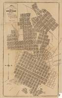
Map of Goldfield, Nevada, April 25, 1907

Date

1907-04-25

Description

'Compiled by James H. Parks, U.S. Deputy Min. Sur., Box 655, Goldfield, Nev. April 25, 1907.' 'Nevada Press Company, Carson City, Nevada.' Scale: [ca. 1:4,800] 1 inch = 400 ft. Plat map. Library's copy has notes handwritten in pencil along right margin with arrows to locations on map: "Ramsey Street ended Columbia St." "MacMaskrs office." "Lived on Euclid ave in adobe house." " Lived in Tent House Sundog Ave."

Image

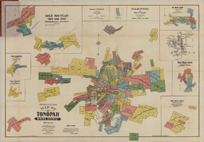
Map of Tonopah Mining District, Nevada, revised edition, 1903

Date

1903

Description

'Compiled and published by Booker & Bradford, engineers, Tonopah, Nevada.' 'Copyrighted by Booker & Bradford 1903.' 'Photo-Lith. Britton & Rey, S.F.' Insets of Ray Mining District, vicinity map of Tonopah Mining District, Utopia Mining District, Tokop Mining District, Weepah Mining District, East Klondike Mining District, Gold Mountain, Tonopah Mining District and Red Mountain. Relief shown by hachures. Includes advertisements. Scale [ca. 1:10,800]. 1 inch to 900 feet.

Image

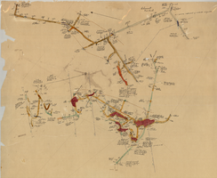
Map of the 450 foot level of the Mohawk Mine, Goldfield, Nevada, circa 1902-1908

Date

1902 to 1908

Description

'(3rd) 450 Ft. level Mohawk.' Hand-drawn, hand-colored and annotated map showing the 450 foot, or third, level of the Mohawk Mine.

Image

Map of the 280 foot level of the Combination Mine, Goldfield, Nevada, circa 1902-1908

Date

1902 to 1908

Description

Hand-drawn, hand-colored and annotated map showing the 280 foot level of the Combination Mine. Printed on map: 'Mohawk, col. el. 5958.48; Hayes & Monnette No. 2, col. el. 5935.7; Hayes & Monnette No. 1, col. el. 5925.8; Truett, col. el. 5938.8; Combination, col. el. 5986.31.'

Image

Map of the 600 foot, or third, level of the Clermont Mine, Goldfield, Nevada, circa 1902-1908

Date

1902 to 1908

Description

Hand-drawn, hand-colored and annotated map showing the 600 foot, or third, level of the Clermont Mine. Handwritten at top of map: 'Clermont, 3rd level.'

Image

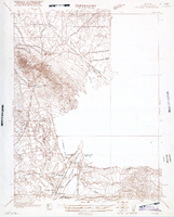
Map of Ely Range Quadrangle, Lincoln County, Nevada, 1921

Date

1921

Description

'Edition of 1921.' 'W. H. Herron, Acting Chief Geographer; Geo. R. Davis, Geographer In Charge; Topography by H. H. Hodgeson, N. E. Ballmer, and W. B. Upton, Jr.; Control by H. H. Hodgeson, Roscoe Reeves, and D. S. Birkett. Surveyed in 1916.' At top of map: ' Topography, State of Nevada.' At upper left corner: ' Department of the Interior, Albert B. Fall, Secretary; U.S. Geological Survey, George Otis Smith, Director.' Southern Nevada Mining Map Collection. 15 minute series (topographic) Nevada.

Image

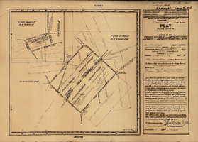
Plat of the claim of George Wingfield, June, 1907

Date

1907-06

Description

'Plat of the claim of George Wingfield, known as the Yankee Doodle and Desert Rose Lodes and Desert Rose Mill Site, in Goldfield Mining District, Esmeralda County, Nevada. Containing an area of 41.318 + 4.841 acres. Scale of 300 feet to the inch. Variation 17° east. Surveyed June 22-25, 1907.' 'Mineral Survey No. 3202 A and B.' 'Pat. # 132432, May 26, 1910.' Certification signed by Matthew Kyle, U.S. General Surveyor's Office, Reno, Nev., December 7, 1907.

Text

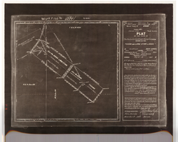
Plat of the Texas and Lone Star Lodes, May, 1905

Date

1905-05

Description

'Plat of the claim of the Rochester Goldfield Mining Company known as the Texas and Lone Star Lodes, in Goldfield Mining District, Nye County, Nevada containing an area of 36.121 acres. Scale of 300 feet to the inch. Variation 17° east. Surveyed May 6-18, 1905, by H. F. Bruce, U.S. Deputy Mineral Surveyor.' Certification signed by Matthew Kyle, U.S. General Surveyor's Office, Reno, Nevada, November 11, 1905. 'Claim located February 3, 1904; amended December 28, 1904.' 'Mineral Survey No. 2330.' At top of plat: 'Vol 459, P 133, No 45841.'

Text

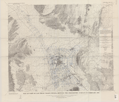
Map of part of Las Vegas Valley, Nevada, showing the piezometric surface in February 1955

Date

1965

Description

Relief shown by contours. Includes township and range lines. Scale 1:96,000 (W 115°30´--W 114°45´/N 36°30´--N 36°00´). Series: Water-supply paper (Washington, D.C.)
1780. Originally published as plate 3 of Available water supply of the Las Vegas ground-water basin, Nevada, by Glenn T. Malmberg, published by the Geological Survey in 1965 as its Water-supply paper 1780.

Image

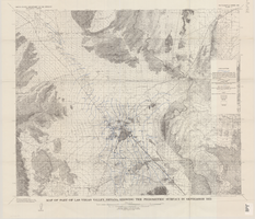
Map of part of Las Vegas Valley, Nevada, showing the piezometric surface in September 1955

Date

1965

Description

Relief shown by contours. Includes township and range lines. Scale 1:96,000 (W 115°30´--W 114°45´/N 36°30´--N 36°00´). Series: Water-supply paper (Washington, D.C.)
1780. Originally published as plate 4 of Available water supply of the Las Vegas ground-water basin, Nevada, by Glenn T. Malmberg, published by the Geological Survey in 1965 as its Water-supply paper 1780.

Image