Search Results
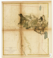
From the valley of the Mud Lakes to the Pacific Ocean
Date
1855
Description
'From explorations and surveys made under the direction of the Hon. Jefferson Davis, Secretary of War, by Capt. E.G. Beckwith, 3rd Artillery, E.G. Egloffstein, topographer for the route. 1855.' ''Selmar Siebert's Engraving & Printing Establishment, Washington, D.C.' Proposed railroad lines highlighted in red and yellow. Published by the War Dept. Scale 1:760,320. 12 miles to 1 in. Relief shown by hachures and spot heights.
Image
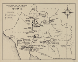
Map of Bureau of Reclamation Region III, August 1, 1945
Date
1945-08-01
Description
31 x 40 cm. "8-1-45. Ness." and "116951" in lower right corner. Shows reclamation projects in operation, under construction, authorized and under study in Arizona, and parts of New Mexico, Utah, Nevada, and California. "Department of the Interior, Bureau of Reclamation" in upper left corner. Original Publisher: Dept. of the Interior, Bureau of Reclamation.
Image
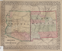
Map of Arizona and New Mexico, 1867
Date
1867
Description
26 x 32 cm. Relief shown by hachures. "Entered according to act of Congress in the year 1867 by S. Augustus Mitchell in the Clerks Office of the District Court for the Eastern District of Pennsylvania." Includes decorative border of grape vines. Shows Tucson as capital of Arizona; shows various trails including Cook's Wagon Route, Marcy's Route, and Kearney's Route. Written in pencil in lower right corner: 135. Original publisher: S.A. Mitchell.
Image
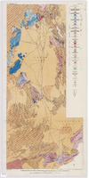
Geologic map of the Atomic Energy Commission Nevada Proving Grounds Area, Nye and Clark Counties, Nevada, 1952
Date
1952
Description
'At top of map: ' United States Department of the Interior. Geological Survey.' ' Bulletin 1021, Plate 32.' At bottom of map: 'Geology by Donald E. Hibbard and Mike S. Johnson, 1952.' 'Base from USAF Aeronautical Chart and Information Service, April 1952.' 'Interior--Geological Survey, Washington, D.C. MR-3767.' Scale 1:63,360 (W 116°10--W 115°55/N 37°15--N 36°40)
Geological Survey bulletin, 1021
Image
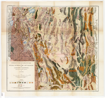
Geological reconnaissance map of Nevada south of the 40th parallel and adjacent California, 1903
Date
1903
Description
'Compiled from all available information by J.E. Spurr. Topographic base chiefly adapted from the maps of the Wheeler Survey.' 'U.S. Geological Survey, Bulletin No. 208, Pl. 1.' 'A. Hoen & Co. Lith. Baltimore, MD.' Relief shown by hachures and spot heights. Scale [ca. 1:950,000. 1 inch to approximately 15 miles] (W 120°--W 114°/N 40°--N 36°). Geological Survey bulletin, 208.
Image

Map of California and Territories of New Mexico and Utah, 1862
Date
1862
Description
Scale [ca. 1:3,231,360. 1 in. to approx. 51 miles] (W 125°00--W 103°30/N 42°00--N 31°45) ; 1 map : hand col. ; 40 x 60 cm., on sheet 46 x 68 cm ; Relief indicated by hachures and spot heights ; Prime meridians: Greenwich and Washington, D.C ; Decorative border ; Hand colored ; Atlas p. numbers in upper margin: 58-59 ; Date est. from territorial borders and county configuration ; Shows natural features, locations of Indian tribes, proposed railroad routes, routes of explorers, trails, county boundaries and populated places ; Johnson and Ward
Image

Map of California and territories of New Mexico and Utah, circa 1861
Date
1859 to 1862
Description
'Compiled, drawn, and engraved under the supervision of J.H. Colton and A.J. Johnson.' Relief shown by hachures and spot heights. Scale [ca. 1:3,041,280]. 1 in. to approx. 48 miles (W 124°--W 103°/N 42°--N 31°). Hand coloredPrime meridians: Greenwich and WashingtonPlates 54 & 55 removed from Johnson's New illustrated family atlas of the world, with descriptions geographical, statistical and historical ... New York, 1862Title page of atlas.
Image
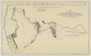
Map of an exploring expedition to the Rocky Mountains in the year 1842 and to Oregon & north California in the years 1843-44
Date
1845
Description
Scale 1:3,000,000. 47.35 miles to 1 in. (W 124°--W 94°/N 46°-- N 34°) ; 1 map ; 76 x 128 cm. ; Relief shown by hachures ; State 3: Includes notes, Great Basin statement, and place name South Park below Bayou Salade; some place names differ from other states ; Includes "Profile of the route from the mouth of the Kansas to the Pacific by Capt. J.C. Fremont in 1843." ; U.S. Senate
Image
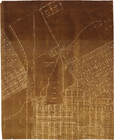
Map of major subdivisions near downtown Las Vegas, Nevada, circa 1931
Date
1928 to 1935
Archival Collection
Description
Map shows deed number and date of deed for some public properties and location and composition of water pipelines. '1-2-31' handwritten in upper right corner. Cadastral maps. Plat map with sepia tone..
Image
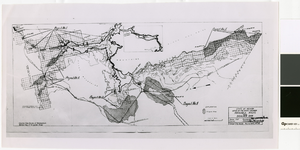
Map of irrigable areas near Boulder Dam, February 20, 1935
Date
1935-02-20
Archival Collection
Description
'Drawn by C.G.C.' 'Carson City, Nevada, Feb. 20, 1935. No. 4.' 'Adapted from Bureau of Reclamation's General map of irrigable areas.'
Image