Search Results
Resolution of the General Council of the Las Vegas Indian Colony, 1969 and Las Vegas Citizens Committee for Community Improvement meeting minutes, February 24, 1969
Date
Archival Collection
Description
Las Vegas Citizens Committee for Community Improvements minutes: report - dump sites, discussion - Lewis Avenue, report - Las Vegas Indian Colony, Discussion - spring cleanup campaign. Angela Sanchez, a member of the the Las Vegas Paiute Colony, was a guest in the meeting. Attached, Resolution of the General Council of the Las Vegas Indian Colony asserting land rights (unsigned).
Text
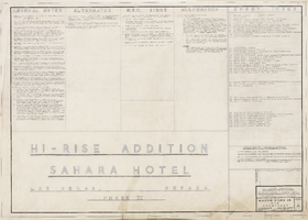
Index to architectural drawings, Hi-rise addition, Sahara Hotel (Las Vegas), April 24, 1959
Date
Archival Collection
Description
Sheet index for the architectural plans for the addition of a hotel tower for the Sahara Hotel. Includes general notes, N.I.C. items, and allowances. Printed on onion skin.
Site Name: Sahara Hotel and Casino
Address: 2535 Las Vegas Boulevard South
Text
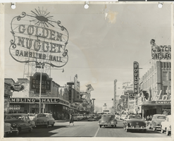
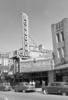
Photograph of the front exterior of the Golden Nugget and Fremont Street (Las Vegas), circa 1951
Date
Archival Collection
Description
Golden Nugget at 129 Fremont Street, circa 1951. Also visible are the Frontier Club, the Vegas Club, the Vegas Vic sign, Union Plaza, the Boulder Club, and Hotel Apache. Note: photograph is damaged.
Site Name: Fremont Street
Address: Fremont street, Las Vegas, NV
Image
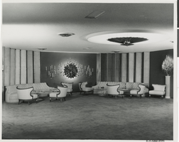
Photograph of the Emerald Room, Sands Hotel (Las Vegas), 1950s
Date
Archival Collection
Description
The Emerald Room in the Sands Hotel and Casino. Stamped on original: "Douglass Studio. Jay Florian Mitchell. Photographer. New Address: 614 South Sixth. Las Vegas, Nevada. Dudley 4-5148."
Site Name: Sands Hotel
Address: 3355 Las Vegas Boulevard South
Image
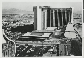
Photograph of the MGM Grand Hotel during its construction (Las Vegas), 1973
Date
Archival Collection
Description
The MGM Grand under construction in 1973. After the 1980 fire, the MGM Grand Hotel was rebuilt in 1981 and sold to Bally's Corporation to become Bally's Las Vegas in 1985.
Site Name: MGM Grand Hotel
Address: 3645 Las Vegas Boulevard South, Las Vegas, NV
Image
Photograph of the front exterior of the Boulder Club (Las Vegas), 1945
Date
Archival Collection
Description
Daytime view of the front exterior of Boulder Club showing its marquee and neon sign. The center of the marquee shows an illustration of Hoover (then Boulder) Dam. Parts of the Club Savoy to the northwest and Apache Bar to the southeast are seen.
Site Name: Boulder Club
Address: 118 East Fremont Street
Image

Film transparency of the Googie style front exterior and parking lot of the Flamingo Hotel (Las Vegas), mid-late 1950s
Date
Archival Collection
Description
Daytime view of the front exterior of the Flamingo Hotel, featuring the Champagne Tower. The neon sign with the Flamingo name features circular neon 'bubbles' like those on the tower.
Site Name: Flamingo Hotel and Casino
Address: 3555 Las Vegas Boulevard South
Image

Film transparency of Fremont Street, Las Vegas, Nevada, at night, circa 1932
Date
Archival Collection
Description
Looking northwest from the corner of Fremont and Second Streets, Las Vegas, Nevada. The Mission Bar is on the southwest corner and the Hotel Apache is on the northwest corner. The Union Pacific Railroad Station is seen at the end of the street.
Site Name: Fremont Street
Address: Fremont Street, Las Vegas, NV
Image
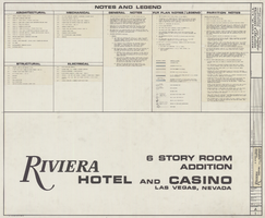
Index to the drawings, legends and general notes, Riviera Hotel 6 Story Room Addition, November 15, 1976
Date
Archival Collection
Description
Plans for a six story addition to the Riviera Hotel from 1976; printed on mylar. Berton Charles Severson, architect; Brian Walter Webb, architect.
Site Name: Riviera Hotel and Casino
Address: 2901 Las Vegas Boulevard South
Image
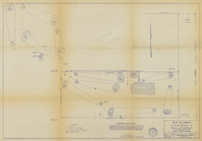
Plat of civil engineering survey for the Hacienda (Las Vegas) golf course addition, January 17, 1958
Date
Archival Collection
Description
Plat of civil engineering survey of the Hacienda golf course. 'Portion of SE 1/4 Section 29 T.21S., R.61E., M.D.B.&M. Clark County, Nevada.' 'Drawn by C.R.M. Checked by L.E.T.' Includes engineer's certificate, signed by L. E. Tyson.
Site Name: Hacienda
Address: 3590 Las Vegas Boulevard South
Image