Search Results
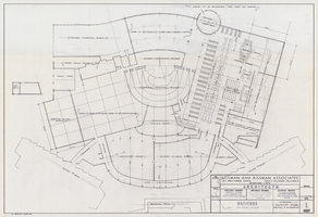
Architectural drawing of the Hacienda (Las Vegas), schematic casino plan additions and alterations, January 15, 1973
Date
Archival Collection
Description
Schematic plans for a casino remodel for the Hacienda in Las Vegas from 1973.
Site Name: Hacienda
Address: 3590 Las Vegas Boulevard South
Image
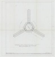
Architectural drawing of the Hacienda (Las Vegas), preliminary plan analysis and proposed trial typical floor plan, May 25, 1954
Date
Archival Collection
Description
Proposed plans for analysis for the design of the Hacienda. Original medium: pencil on paper.
Site Name: Hacienda
Address: 3590 Las Vegas Boulevard South
Image
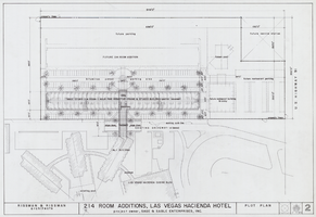
Architectural drawing of the Hacienda (Las Vegas), plot plan, September 14, 1961
Date
Archival Collection
Description
Plot plan for the 214 room addition to the Hacienda. Sage and Sable Enterprises, Inc., project owners.
Site Name: Hacienda
Address: 3590 Las Vegas Boulevard South
Image

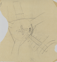
Film negative, architectural drawing of the proposed Lady Luck casino (Las Vegas), plot plan, before 1956
Date
Archival Collection
Description
Plot plan of the proposed Lady Luck, later named the Hacienda. Inverted negative film transparency.
Site Name: Hacienda
Address: 3590 Las Vegas Boulevard South
Image
Architectural sketch of the Hacienda (Las Vegas), rough sketch, 1951-1956
Date
Archival Collection
Description
Rough planning sketch of the Lady Luck, later the Hacienda. Original medium: pencil on tissue paper
Site Name: Hacienda
Address: 3590 Las Vegas Boulevard South
Image
Charles Rozaire work correspondence
Date
Archival Collection
Description
Mixed Content
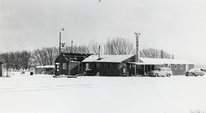
Bar in Carver's Station, Nevada: photographic print
Date
Archival Collection
Description
From the Nye County, Nevada Photograph Collection (PH-00221) -- Series V. Smoky Valley, Nevada and Round Mountain, Nevada -- Subseries V.A. Carver, Carver-Duhme, and Carver-Book Families (Smoky Valley). Originally the bar room in Carver’s Station was rather narrow; it was widened by bolting a number of 2-by-12s together and using that as a roof beam. Ground motion from the first atmospheric atomic test at the Nevada Test Site, located to the south, produced so much shaking that it broke the beam and caused the roof to sag. Ground motion from the nuclear tests at the Nevada Test Site is a common experience in Smoky Valley, and residents state that they sometimes feel motion from underground tests. Jean Carver Duhme still instinctively notes the time of any earth motion to determine if it is caused by an announced atomic test or by an earthquake. When tests were conducted in the atmosphere, Jean Carver Duhme does not recall seeing any visible clouds containing radioactive material moving up the Valley from the Test Site, but believes that the uranium "boom" during the 1950s at the Northumberland in the Toquima Mountains can be attributed more to fallout from nuclear testing than to naturally occurring uranium. During the atmospheric testing period, residents in Smoky Valley wore dosimeter badges, devices for measuring individual exposure to radiation. Dick Carver remembers his first experience of an atomic device being set off in the atmosphere at the Test Site. He arose very early one morning to go fishing in Jett Canyon in the Toiyabe Mountains. Prior to daylight he remembers seeing a "big flash of light.. brighter than daylight. And then it [got] dark again. It's amazing how bright it was," he recalls.
Image
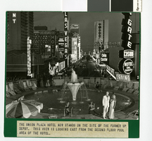
Photograph of Fremont Street from the Union Plaza Hotel, Las Vegas (Nev.), 1970s
Date
Archival Collection
Description
Image
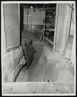
Photograph of construction worker and employee during Stardust renovation, Las Vegas, (Nev.), March 18, 1975
Date
Archival Collection
Description
Image
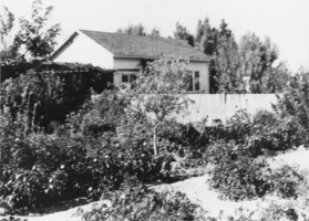
House and garden belonging to Gordon and Billie Bettles: photographic print
Date
Archival Collection
Description
From the Nye County, Nevada Photograph Collection (PH-00221) -- Series I. Amargosa Valley, Nevada -- Subseries I.A. Fishel Family (T&T Ranch). The house was occupied by Betty-Jo Boyde and her husband in 1990, was moved to the site by the Bettles from Death Valley Junction, California. The site was bare land when the Bettles moved onto it. As this picture testifies, Billie Bettle's reputation as a skilled gardener is fully justified.
Image