Search Results

Topographic map of the southeast quadrangle of the metropolitan Las Vegas, Nevada area, 1967
Date
Description
Image

Topographic map of the southwestern quadrangle of the metropolitan Las Vegas, Nevada area, 1973
Date
Description
Image

Topographic map of the southwestern quadrangle of the metropolitan Las Vegas, Nevada area, 1967
Date
Description
Image

Map of Las Vegas Valley, Clark County, Nevada, 1954
Date
Description
Image
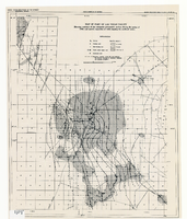
Map of part of Las Vegas Valley showing contours of the composite piezometric surface during the spring of 1944, and specific capacities of wells tapping the confined water
Date
Description
Relief shown by contours. Includes range and township grid. Shows springs and wells. Scale [ca. 1:67,162. 1 in. to approx. 1.06 miles]. Series: Water resources bulletin (Carson City, Nev.)
no. 5. Originally published as plate 8 in Geology and water resources of Las Vegas, Pahrump, and Indian Spring Valleys, Clark and Nye Counties, Nevada by George B. Maxey and C.H. Jameson, which is number 5 of the Water resources bulletin published by the Nevada Office of the State Engineer.
Image
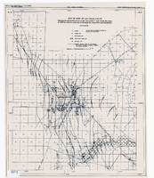
Map of part of Las Vegas Valley showing the piezometric surface of the "near-surface" water during the spring of 1946 by contours, and areas of discharge by evaporation and transpiration
Date
Description
Relief shown by contours. Includes range and township grid. Shows springs, wells and areas of discharge. Scale [ca. 1:67,162. 1 in. to approx. 1.06 miles]. Series: Water resources bulletin (Carson City, Nev.)
no. 5. Originally published as plate 7 in Geology and water resources of Las Vegas, Pahrump, and Indian Spring Valleys, Clark and Nye Counties, Nevada by George B. Maxey and C.H. Jameson, which is number 5 of the Water resources bulletin published by the Nevada Office of the State Engineer.
Image
University of Nevada, Las Vegas Anniversaries Event Records
Identifier
Abstract
The University of Nevada, Las Vegas (UNLV) Anniversaries Event Records (1982 to 2008) are comprised of memorabilia, event planning files, promotional material, and publications that celebrate the university's 25th anniversary in 1982; the 40th anniversary in 1997; and the 50th anniversary in 2007.
Archival Collection
Gwendolyn Woolley Photographs
Identifier
Abstract
The Gwendolyn Woolley Photographs contain photographs from Las Vegas, Nevada from approximately 1934 to 1953. The photographs primarily depict students at the Junior Prom at Las Vegas High School in 1953. The photographs also depict members of the Ladies Society of Brotherhood of Firemen and Locomotive Engineers at the first Helldorado Parade in Las Vegas, Nevada.
Archival Collection