Search Results
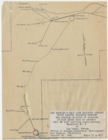
Map showing location of proposed 12-inch water main to connect Well #8 with settling basin serving Reservoir No. 2 at Las Vegas, Nevada, January 16, 1950
Date
1950-01-16
Archival Collection
Description
'Office of Manager-Industrial Development, Los Angeles, California.' Scale: 1" = 600'. 10 3/8 in. x 8 in.
Image
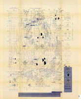
Map of the Nevada Test Site and vicinity showing principal rock types and chemistry of ground water, 1964
Date
1964
Description
'Compiled by S.L. Schoff and J.E. Moore.' 'Geology generalized from geologic maps of the Nevada Test Site by Special Projects Branch, U.S. Geological Survey; of Lincoln County by Tschanz and Pampeyan (1961); and of Clark County by Bowyer, Pampeyan, and Longwell (1958).' United States Department of the Interior, Geological Survey. Prepared in cooperation with the U.S. Atomic Energy Commission.' 'TEI-838.' Scale 1:125,000 (W 116°00´--W 116°15´/N 37°15´--N 36°30´). Originally published as figure 1 in Chemistry and movement of ground water, Nevada Test Site / by Stuart L. Schoff and John E. Moore, published by the Geological Survey in 1964 as number 838 of the Trace elements investigations report.
Image
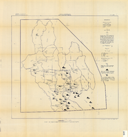
Map showing chemical diagrams representing quality of water in Clark and Nye counties, Nevada, 1963
Date
1963
Description
'T.E. Eakin, S.L. Schoff, and P. Cohen, 1963.' 'Department of the Interior, United States Geological Survey, TEI-833.' 'Prepared in cooperation with the U.S. Atomic Energy Commission.' Scale 1:500,000 (W 117°00´--W 115°00´/N 38°30´--N 36°30´). Originally published as figure 3 in Regional hydrology of a part of southern Nevada : a reconnaissance / by Thomas E. Eakin, Stuart L. Schoff, and Philip Cohen, published by the U.S. Geological Survey in 1963 as number 833 of the Trace elements investigation report.
Image
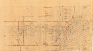
Map of Las Vegas showing areas owned by the Union Pacific Railroad Company, water pipes and other water utilities, circa 1942
Date
1938 to 1946
Archival Collection
Description
Map showing downtown Las Vegas and tracts to the west showing water supply lines, wells, springs, and settling basins. Various areas outlined in red and yellow. Scale [ca. 1:7,200] 1 in.=600 feet. Cadastral map. Blueline print. Areas owned by railroad outlined by hand in different colored markers. Library's copy includes hand-written calculations.
Image
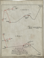
Sketch of plan and profile of present and proposed pipes and tanks and reservoirs at Sloan, Erie and Jean, Nevada, circa 1910s-1920s
Date
1910 to 1929
Archival Collection
Description
'No scale. Approved E.M. Jessup, Engr. Maintenance. 7-R-463.'
Image
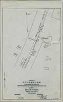
Map showing water connection for jail, Moapa, Nevada, December 28, 1914
Date
1914-12-28
Archival Collection
Description
'Exhibit A.' 'S.P.L.A.&.S.L.R.R., Los Angeles Division.' 'Approved, [signed] E.M. Jessup, E. M. of W.' 2-T-167A' hand-printed in lower right corner. Scale: 1 in. = 100 ft.
Image
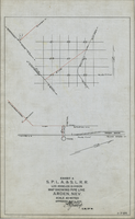
Map showing water pipeline in Arden, Nevada, May 4, 1913
Date
1913-05-04
Archival Collection
Description
'Exhibit A. S.P.L.A. & S.L.R.R. Los Angeles Division.' 'Approved May 4, 1913 [signed] E.M. Jessup, E.M. of W.' 'I-T-54.'
Image

Map showing proposed new 12" well and pipe line changes at Water Springs, Las Vegas, Nevada, circa 1920
Date
1916 to 1925
Archival Collection
Description
In lower right corner: '6-W-74.' Scale: 1" = 500'.
Image
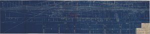
Map showing possible industrial users' connections to railroad pipelines in Las Vegas, Nevada, December 4, 1930
Date
1930-12-04
Archival Collection
Description
Stamped portion near lower right corner reads 'Union Pacific System, L.A. & S.L. R.R. Scale: 1" = 100'. Date: 12-4-30. Office Division, Eng'r. Los Angeles. Drg. No. 916.' 10 3/4 in. x 33 3/4 in. Scale: 1" = 100"..
Image
Map showing location of proposed water lines serving Industrial Tract No. 1, Las Vegas Nevada, March 21, 1931
Date
1931-03-21
Archival Collection
Description
'Office of Ind'l. Engineer, Los Angeles, California.' 'Dwg. No. 568.' Scale: 1" = 100'.
Image