Search Results
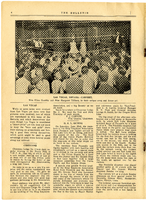
Stewart family real estate documents
Date
1920 to 1929
Archival Collection
Description
Stewart family real estate documents
Text
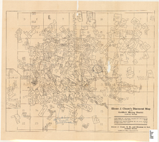
Map of the Goldfield Mining District, Goldfield, Nevada, 1907
Date
1907
Description
'Elmer J. Chute, E.M. and Olmstead and Rich, Goldfield, Nevada. Copyright 1907, by Elmer J. Chute, Goldfield, Nev.' Includes information on and prices for wall and pocket map with this title. Includes inset map. Includes township and range grid. Library's copy has Rochester GF. claim circled in blue ink , has a piece missing to the right of that claim, and has "Mohawk ledge, a lease by Davis & Shoemaker" written in blue ink at the center bottom of the map with a line in blue ink drawn to the Frances Mohawk claim.
Image

Map showing proposed annexation of Las Vegas Valley, Clark County, Nevada, January 1, 1929
Date
1929-01-01
Description
'Compiled by C. D. Baker, C.E., United States Mineral Surveyor, State Right Water Surveyor, Nevada. Las Vegas, Nev. January 1, 1929. Copyright applied for.' ; "Filed Dec. 10, 1936" and signed by Viola Burns, clerk, city of Las Vegas ; Hand-printed title at top of map: Proposed annexation to Las Vegas ; Map is stamped as Filed Dec 10, 1936 and signed by Las Vegas City Clerk Viola Burns. Library's copy has brown line hand-drawn around area to be annexed.
Image
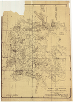
Map of approved mineral surveys in the Goldfield Mining District, Esmeralda and Nye Counties, Nevada, 1911
Date
1911
Description
'Compiled from records of the U.S. Surveyor General and other authentic sources by Davis and Byler, Mining Engineers, Goldfield, Nevada. Copyright 1908 by Davis and Byler. 1911.' Scale [ca. 1:9,600]. 1 in. to 800 feet. (W 117°14'--W 117°09'/N 37°46'--N 37°41'). Blueline print. Includes township and range grid. Library's copy has upper-left corner torn off and has circles drawn around and diagonal lines drawn on certain claims.
Image
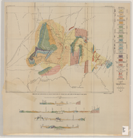
Geologic map and sections of Muddy Mountains, St. Thomas Gap, and part of the Grand Wash Cliffs, 1928
Date
1928
Description
'Geology by C.R. Longwell.' At top of map: 'U.S. Geological Survey Bulletin 798, plate 1.' Includes four colored cross-sections. 1:250,000 (W 115°00'--W 113°45'/N 36°45'--N 36°00'). Series: Bulletin (Geological Survey (U.S.)no. 798. Originally published as plate 1 in: Geology of the Muddy Mountains, Nevada, with a sections through the Virgin Range to the Grand Wash Cliffs, Arizona / by Chester R. Longwell. Washington, D.C. : Government Printing Office, 1928. (Bulletin ((Geological Survey (U.S.)), no. 798).
Image
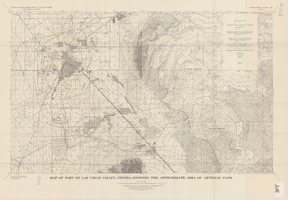
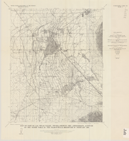
Map of part of Las Vegas Valley, Nevada, showing the approximate area of artesian flow, 1965
Date
1965
Description
At top of map: 'United States Department of the Interior, Geological Survey. Water supply paper 1780, plate 2.' At bottom of map: 'Base from U.S. Geological Survey Las Vegas (1952) and Henderson (1952) quadrangles.' 'Interior--Geological Survey, Washigton, D.C.--1965--W63358.' Relief shown by contours. Includes township and range lines. Thematic map. Scale 1:62,500 (W 115°15´--W 114°45´/N 36°15´--N 36°00´). Series: Water-supply paper (Washington, D.C.)1780. Originally published as plate 2 of Available water supply of the Las Vegas ground-water basin, Nevada, by Glenn T. Malmberg, published by the Geological Survey in 1965 as its Water-supply paper 1780.
Image
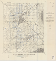
Map of part of Las Vegas Valley, Nevada, showing the approximate piezometric surface in 1912
Date
1965
Description
'Base by U.S. Geological Survey, 1952.' 'Interior--Geological Survey, Washington, D.C.--1965--W63358.' 'Compiled from data published by Carpenter (1915), Kearney (1913), and McWilliams (1913).' Relief shown by contours. Includes township and range lines. Scale 1:62,500 (W 115°15´--W 115°00´/N 36°15´--N 36°00´). Series: Water-supply paper (Washington, D.C.)1780. Originally published as plate 7 of Available water supply of the Las Vegas ground-water basin, Nevada, by Glenn T. Malmberg, published by the Geological Survey in 1965 as its Water-supply paper 1780.
Image
Map of part of Las Vegas Valley, Nevada, showing the approximate altitude of the water table in the near-surface reservoir in February 1956
Date
1965
Description
Genre/Form: Thematic maps. Scale 1:62,500 (W 115°15´--W 115°00´/N 36°15´--N 36°00´). 1 map ; 45 x 36 cm. Series: Water-supply paper (Washington, D.C.) ; 1780. Relief shown by contours. Originally published as plate 8 of Available water supply of the Las Vegas ground-water basin, Nevada, by Glenn T. Malmberg, published by the Geological Survey in 1965 as its Water-supply paper 1780. Includes township and range lines. Interior, Geological Survey
Image