Search Results
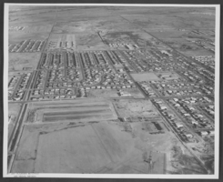
Aerial photograph of part of the Las Vegas Valley, circa 1963
Date
1962 to 1964
Archival Collection
Description
Aerial photograph of the greater Las Vegas, Nevada area, showing housing subdivisions.
Image
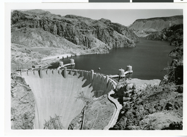
Aerial photograph of Hoover Dam and Lake Mead, 1935-1936
Date
1935 to 1936
Archival Collection
Description
Aerial view of the downstream face of Hoover Dam and Lake Mead, in Black Canyon. The dam's intake towers are seen in the lake.
Image
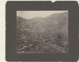
Aerial photograph of Pioche, Nevada, circa 1880s-1890s
Date
1880 to 1899
Archival Collection
Description
An aerial view of Pioche, Nevada. The Dexter Stables, Marysville Hotel, J. J. Halpin &Co. Hardware and another hardware store, furniture stores and a tobacco store are identified.
Image
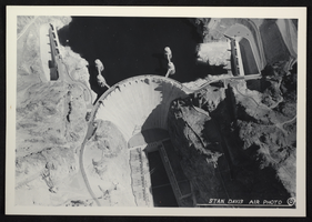
Aerial photograph of Hoover Dam, circa mid 1930s
Date
1935 to 1936
Archival Collection
Description
An image showing an aerial view of Hoover Dam. Note: Boulder Dam was officially renamed Hoover Dam in 1947.
Image
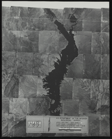
Aerial view of the Bonelli quadrant in Arizona-Nevada: photographic print
Date
1950
Archival Collection
Description
From the Army Mapping Service Aerial Photographs of Southern and Western Nevada (PH-00285). Aerial photographs, composites, and indices. High altitude aerial photographs, Quad. Bonelli, State: Arizona - Nevada. U.S. Geological Survey, Army Map Service. Flight Scale I-47200Project-GS-LJ. Index copied -8-26-50. Flying Comp. -7-26-50
Image
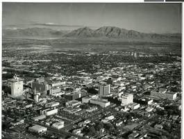
Aerial photograph of downtown Las Vegas, circa 1966-1969
Date
1966 to 1969
Archival Collection
Description
Aerial view of downtown Las Vegas, looking southeast.
Image

Slide of aerial view of Las Vegas, circa early 1900s
Date
1900 to 1929
Archival Collection
Description
Aerial view of Las Vegas.
Image
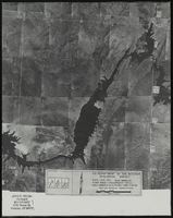
Aerial view of the Bonelli quadrant in Arizona-Nevada: photographic print
Date
1950
Archival Collection
Description
From the Army Mapping Service Aerial Photographs of Southern and Western Nevada (PH-00285). Aerial photographs, composites, and indices. Aerial photographs, Quad. Bonelli 4, U.S. Department of the Interior Geological Survey, Army Map Service. State: Arizona - Nevada. Flight Scale I-47200Project-GS-LJ. Index copied -8-26-50. Flying Comp. -7-26-50
Image
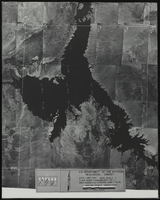
Aerial view of the Bonelli quadrant in Arizona-Nevada: photographic print
Date
1952
Archival Collection
Description
From the Army Mapping Service Aerial Photographs of Southern and Western Nevada (PH-00285). Aerial photographs, composites, and indices. High altitude aerial photographs, Quad. Bonelli 3, State: Arizona - Nevada. U.S. Geological Survey, Army Map Service. Flight Scale I-47200Project-GS-LJ. Index copied -8-26-50. Flying Comp. -7-26-50
Image
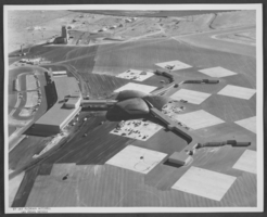
Aerial photograph of McCarran Airport, Las Vegas, Nevada, circa 1963
Date
1962 to 1964
Archival Collection
Description
Aerial photograph of McCarran Airport, Las Vegas, Nevada.
Image