Search Results
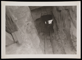
Photograph of mine shaft, Sheep Mountain Range, 1931
Date
1931
Archival Collection
Description
Looking up inside the mine shaft previously pictured in the Sheep Mountains of Nevada.
Image
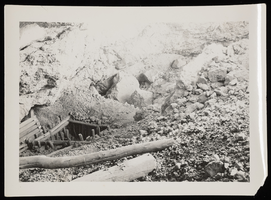
Photograph of miner and mine owner, Sheep Mountain Range, 1931
Date
1931
Archival Collection
Description
Miner and the mine owner stand next to machinery and the mine's entrance at the Sheep Mountain Range in Nevada.
Image
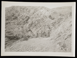
Photograph of mine entrance, Sheep Mountain, 1931
Date
1931
Archival Collection
Description
Entrance to mine on the Sheep Mountain Range in Nevada. For more mine images at the Sheep Range, see 0123 0178-0180.
Image
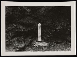
Photograph of miner's monument, Kingman Wash (Ariz.), circa 1932
Date
1931 to 1933
Archival Collection
Description
Miner's monument for Joseph Herber Richards at Kingman Wash. He died June 18, 1917 and had previously owned the mine at Sheep Mountain. Note reads: "He died in Kingman Wash, 300 yards from Colorado River. His miners pick is imbedded in the cement." - W. A. Davis, April 1992.
Image
Photograph of C. N. Cross' mining claim, Las Vegas (Nev.), January 26, 1929
Date
1929-01-26
Archival Collection
Description
C. N. Cross' mining claim of Solitary Mine in Clark County Nevada on January 26, 1929. Notes with photo read, "Claim on butte that now is an island in the lake. Wint has the claim papers. Called Solitary Mine - Clark County, Nev, 24th Jan., 1929. Wint, Emory's son, Ayers daughter, and others would ride burros up to this location and cook hot dogs and then return by moonlight."
Image
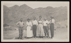
Photograph of Beckleys and miners, Las Vegas (Nev.), 1913
Date
1913
Archival Collection
Description
Beckleys stand with unidentified miners in the desert of Las Vegas near a gold mine. Identified from left to right: "1) Miner, 2) Miner's Wife, 3) Will Beckley, 4) Leva Beckley, 5) Watelet (Engineer), 6) Jake Beckley."
Image
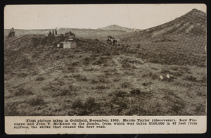
Photograph of desert landscape and people, Goldfield (Nev.), December 1903.
Date
1903-12
Archival Collection
Description
First picture taken in Goldfield, December, 1903. Harrie Taylor (discoverer). Lew Finnegan and John Y. McKane on the Jumbo, from which was taken $100,000 in 47 feet surface, the strike that caused the first rush.
Image

Tonopah, Nevada mining map, March 1904
Date
1904-03
Description
'U.S. Geological Survey, George Otis Smith, Director.' 'R.U. Goode, Geographer in charge. Triangulation by U.S. Coast and Geodetic Survey. Topography by W.J. Peters. Surveyed in 1902-1903.' 'Edition of Mar. 1904, reprinted Apr. 1910.' Oriented with north toward the upper left. Relief shown by contours and hachures. Scale 1:12,000 (W 117°14´--W 117°12´/N 38°05´--N 38°03´)
Text
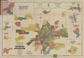
Map of Tonopah Mining District, Nevada, revised edition, 1903
Date
1903
Description
'Compiled and published by Booker & Bradford, engineers, Tonopah, Nevada.' 'Copyrighted by Booker & Bradford 1903.' 'Photo-Lith. Britton & Rey, S.F.' Insets of Ray Mining District, vicinity map of Tonopah Mining District, Utopia Mining District, Tokop Mining District, Weepah Mining District, East Klondike Mining District, Gold Mountain, Tonopah Mining District and Red Mountain. Relief shown by hachures. Includes advertisements. Scale [ca. 1:10,800]. 1 inch to 900 feet.
Image
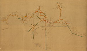
Map of the 450 foot level of the Mohawk Mine, Goldfield, Nevada, circa 1902-1908
Date
1902 to 1908
Description
'(3rd) 450 Ft. level Mohawk.' Hand-drawn, hand-colored and annotated map showing the 450 foot, or third, level of the Mohawk Mine.
Image