Search Results

Cross-section maps of Combination and Florence Mines, Goldfield, Nevada, circa 1902-1908
Date
1902 to 1908
Description
Maps of Combination and Florence Mines, Goldfield, Nevada.
Image
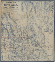
Miners map of Death Valley and the proposed Salt Lake railroads, January 1903
Date
1903-01
Description
Subtitle: 'Including portions of San Bernardino and Inyo Counties, California; Nye and Lincoln Counties, Nevada and Mojave County, Arizona.' 'Compiled and drawn by A. Russell Crowell.' 'May 1902 (Corrected to Jan. 1903.' 'Property of H. Kehoe' written in ink in upper left corner. Scale [ca. 1:506,880]. 1 in. to 8 miles (W 118?--W 114?/N 38?--N 35?). Relief shown by hachures and spot heights. Blueline print. Library's copy has types of minerals found in different areas hand-printed in red and has red lines hand-drawn along county boundaries. G4351.H1 1903 .C76
Image

Map of Las Vegas, Nevada and surrounding Bureau of Land Management areas to the west and north, 1994
Date
1994
Description
'BLM edition, 1994.' 'Surface management status; mineral management status.' '1:100,000-scale topographic map showing highways, roads and other manmade structures; water features; contours and elevations in meters with conversions to feet; BLM recreation sites.' 'Edited and published by the Bureau of Land Management. Base map prepared by the U.S. Geological Survey.' I53:11/4-2
Text

Map of the state of Nevada to accompany the annual report of the Commr. Genl. Land Office, October 2, 1866
Date
1866-10-02
Description
'Department of the Interior, General Land Office, October 2nd, 1886, [signed] Jos. S. Wilson, Commissioner.' 'The Major & Knapp Eng. Mfg. & Lith. Co. 71 Broadway, N.Y.' Relief shown by hachures. Hand colored. Shows silver, gold, and copper mines. Scale [1:1,140,480]. 18 miles to an in. (W 120°--W 114°/N 42°--N 35°)
Image

Sectional maps for the Combination and Florence Mines, Goldfield (Nev.), 1900-1925
Date
1900 to 1925
Description
Sectional mining map, vertical orientation
Image
Report of the Diamond Valley Gold Mining Company, January 14, 1915
Date
1915-01-14
Archival Collection
Description
Report of the Diamond Valley Gold Mining Company, January 14, 1915
Text
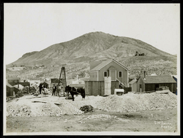
Photograph of mining operations, Goldfield (Nev.), 1900-1925
Date
1900 to 1925
Archival Collection
Description
Photograph of mining operations, Goldfield (Nev.), 1900-1925
Image
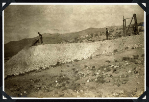
Photograph of a man dumping excavated rock, Round Mountain (Nev.), 1900-1925
Date
1900 to 1925
Archival Collection
Description
Photograph of a man dumping excavated rock, Round Mountain (Nev.), 1900-1925
Image
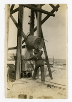
Photograph of a miner working topside filling an ore cart, Goldfield (Nev.), 1907
Date
1907
Archival Collection
Description
Photograph of a miner working topside filling an ore cart, Goldfield (Nev.), 1907
Image
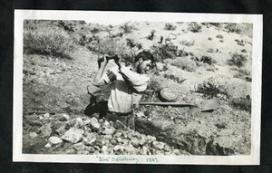
Photograph of Jim Salisbury digging a trench, Eldorado Canyon (Nev.), 1907
Date
1907
Archival Collection
Description
Transcription on front reads "Jim" Salisbury 1907
Image