Search Results
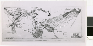
Map of irrigable areas near Boulder Dam, February 20, 1935
Date
1935-02-20
Archival Collection
Description
'Drawn by C.G.C.' 'Carson City, Nevada, Feb. 20, 1935. No. 4.' 'Adapted from Bureau of Reclamation's General map of irrigable areas.'
Image
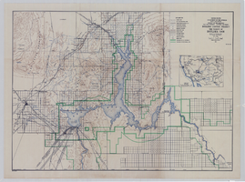
Topographic map of Boulder Canyon Project, Boulder Dam area, 1940
Date
1940
Description
Scale [ca. 1:221,760. 1 in. to approx. 3.5 miles] ; 1 map : col. ; 51 x 71 cm ; Relief shown by contours and spot heights ; Includes township and range grid ; "Map no. 40-40" ; Includes index map ; Shows power lines, triangulation stations, boundary monuments, roads, telephone lines, mines, bench marks, etc. ; U.S. Dept. of the Interior, Bureau of Reclamation
Image

Map of Boulder Dam area and Las Vegas, Nevada, October 7, 1930
Date
1930-10-07
Description
'F.V. Owen, publisher ... Los Angeles, California. Topography by C.H. Fenner, C.E. Decorations by L.J. Bergère. Gov't. data, H.A. Shamberger, C.E. Copyright, 1930, by F.V. Owen.' At bottom right of map: 'Dated Oct. 7th, 1930.' Relief shown by contours and spot heights. Contour lines are 100 feet. Incudes six hand-colored illustrations showing local points of interest. Includes information on Hoover Dam, and chart of mileages from Las Vegas. Scale [ca. 1:63,360]. 1 inch to 1 mile
Text
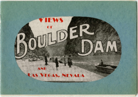
Views of Boulder Dam and Las Vegas, Nevada
Description
"N.E. Johnson, photographer and publisher." Booklet consists primarily of photographs of the Colorado River in Black Canyon, prior to the construction of Hoover (Boulder) Dam, and photographs of people and businesses in early 20th-century Las Vegas.
Text
Boulder Dam Postage Stamp
Identifier
MS-00052
Abstract
The collection consists of one three-cent United States (U.S.) postage stamp from 1935 featuring Boulder Dam, located on the Arizona-Nevada border.
Archival Collection
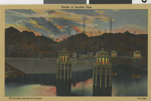
Sunset at Boulder Dam: postcard
Date
1930 (year approximate) to 1939 (year approximate)
Archival Collection
Description
Colored postcard depicting Sunset at Boulder Dam. (c. 1930s)
Mixed Content
Hoover (Boulder) Dam
Level of Description
File
Archival Collection
Lake-Eglington Family Photograph Collection
To request this item in person:
Collection Number: PH-00010
Collection Name: Lake-Eglington Family Photograph Collection
Box/Folder: N/A
Collection Name: Lake-Eglington Family Photograph Collection
Box/Folder: N/A
Archival Component
Boulder Dam, 1956
Level of Description
File
Archival Collection
J. A. Tiberti Construction Records
To request this item in person:
Collection Number: MS-00855
Collection Name: J. A. Tiberti Construction Records
Box/Folder: Box 005
Collection Name: J. A. Tiberti Construction Records
Box/Folder: Box 005
Archival Component
Boulder Dam, undated
Level of Description
File
Archival Collection
Lake-Eglington Family Photograph Collection
To request this item in person:
Collection Number: PH-00010
Collection Name: Lake-Eglington Family Photograph Collection
Box/Folder: Folder 03
Collection Name: Lake-Eglington Family Photograph Collection
Box/Folder: Folder 03
Archival Component